Schäfler
| Schäfler | ||
|---|---|---|
|
The Schäfler (July 2006) from Ebenalp (northeast) |
||
| height | 1925 m above sea level M. | |
| location | Canton of Appenzell Innerrhoden , Switzerland | |
| Mountains | Alpstein , Appenzell Alps | |
| Dominance | 0.85 km → Altenalptürm | |
| Notch height | 116 m ↓ Altenalpsattel | |
| Coordinates | 747 716 / 237976 | |
|
|
||
|
The Schäfler seen from the south high above the Seealpsee. On the right edge of the picture the Zisler wall. |
||
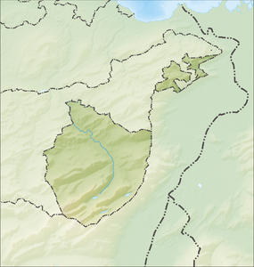
The Schäfler is a peak in the Swiss canton of Appenzell Innerrhoden with an altitude of 1925 m . It is a popular excursion destination in the Alpstein region and is located high above the Seealpsee in the northern Alpstein chain.
Surname
In the dialect the mountain is called [də ʃœːfflə (r)], the first mention comes from 1740 as Schäffler . The name is thus similar to the word "Schafe" (Swiss German [ʃœːf]).
Access

A route leading from the upper station of the Ebenalp cable car (1590 m) firstly down through the dark hole of Wildkirchli-cavity system, past the Hermit House , the Wildkirchli and along the Zislerwand, via the Schäflerrücken and a few meters below the top of the mountain restaurant Schäfler by on the 1925 meter high summit. However, it can also be reached directly from Seealpsee via Äscher or from the north, from Lehmen.
A continuation of the hike in a westerly direction towards the Säntis is only suitable for hikers who are used to the mountains and with suitable footwear .
Further descents to Altenalp or in the direction of Mesmer , Seealpsee or further in the direction of Meglisalp also lead over the somewhat exposed ridge path.
Web links
Individual evidence
- ↑ S. Sonderegger: The place and field names of the Land of Appenzell, Vol. I: 545, Frauenfeld 1958


