Natanz
| Natanz | ||
|---|---|---|
| Mausoleum of Mir Sayed Vaghef | ||
|
|
||
| Basic data | ||
| Country: |
|
|
| Province : | Isfahan | |
| Coordinates : | 33 ° 30 ′ N , 51 ° 55 ′ E | |
| Height : | 1710 m | |
| Residents : | 11,138 (2007) | |
| Time zone : | UTC +3: 30 | |
Natanz or Natans ( Persian نطنز, DMG Naṭanz ) is a city in the dry central part of Iran , in the Isfahan province , about 225 km south-southeast of Tehran . Fruit is grown in the oases , with pears being particularly popular throughout Iran.
location
Natanz is located on the eastern flank of the Kuhrud Mountains, about a third of the way between the Namak salt lake and the city of Isfahan , to whose province it belongs. Their main transport connection is the southeast extending highway Qom - Kaschan -Isfahan while the railway line, 10 km east approximately over the path node of the oasis city Badrud ( 33 ° 42 ' N , 52 ° 1' O passes).
The district town of Kashan is about 40 km northwest. There are shrines spread over the region, such as the tomb for the Sufi - Sheikh Abd as-Samad al-Isfahani , which his student, the vizier of the Ilkhan Zain al-Din Mastari, built for him from 1304 .
Some peaks of the 700 km long Kuhrud Mountains are 10 to 20 km away from the city; its highest is the Kuh-e Karkas (3896 m). There is said to be 330 BC Chr. Dareios III. , the last great king of the Achaemenid dynasty , was slain. Historiography, however, locates the place where Darius III. from its relative, the Satraps Bessos was killed, near Ahevanu ( 35 ° 46 ' N , 53 ° 44' O ) in the province of Semnan , far easterly and northerly than Natanz. The cool high mountain valley is a fertile irrigation oasis with canals, the green fruit trees of which form a contrast to the Dascht-e Kawir salt desert to the east.
Cityscape
The city has about 11,000 inhabitants and the district of the same name just under 47,000.
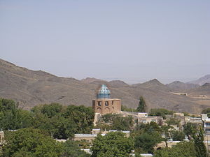
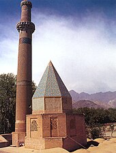
A Tschahar Taq and the remains of a fortress come from the Sassanid period . The Ilkhanids left behind the small mosque Kucha Mir with a Seljuk stucco mihrab from the 12th century. A caravanserai dating back to the Safavid is dated early 17th century. The mausoleum of Mir Sayed Vaghef is a tomb for one of the many revered men in the region. The large Friday mosque behind the market was built in the 14th century. The most important monument in the city is the mausoleum of Sheikh Abd as-Samid, built in 1307/08, next to the Friday mosque. The free-standing minaret next to the mausoleum is the eye-catcher visible from afar in the center of the village. The portal of a mosque built in 1304 is the entrance to the building complex, the buildings of which are arranged on different levels and at different angles. The mosque consists of four ivans around a central courtyard. An octagonal dome with a mihrab adjoins it to the south .
Since the nearby uranium enrichment facility was built , the population has increased and land prices have quintupled. However, there are fears for tourism. The new development areas are to be located on the western side of the city facing away from the facility.
Surroundings
Abyaneh
The oasis village Abyaneh ( 33 ° 35 ' N , 51 ° 36' O ) is in the south-east of Natanz in the flank of the karkas mountains . The houses step up the steep mountain slope. Since they are made of mud bricks made from the red earth of the area, Abyāneh is called the Red Village . It is a popular summer residence for the residents of Tehran and is visited by many tour groups. Until the introduction of the Twelve Shia as the state religion by the Safavid Shah Ismail I , it was predominantly inhabited by followers of the ancient Persian Zoroastrian faith .
Although many residents emigrated to India or Yazd at that time , customs such as dress fashions (women wear colorful dresses instead of black, which is predominant in Iran) and even the old dialect have been preserved. The main road leads through the ruins of a former Zoroastrian fire temple . On the mountains around the village there are other ruins of Zoroastrian buildings and a fortress from the time of the Ilkhan.
Komshecheh mine
In a mountainous region located approximately 30 km to the east is the Komshecheh -Mine ( 33 ° 14 '0 " N , 52 ° 3' 0" O ), an important reservoir for the minerals fluorite and barite (river and barite). The former is particularly well crystallized in a saddle-shaped large fold of a limestone and dolomite formation. In terms of quantity, barite mining is of greater economic importance.
Nuclear facility
The city was internationally mainly by the nearby underground nuclear plant Natanz for uranium enrichment known ( 33 ° 43 '29 " N , 51 ° 43' 29" O ) in 2002 in the course of nuclear inspections of IAEA was discovered (see Nuclear program of Iran ).
climate
|
Average monthly temperatures and precipitation for Natanz
Source: weather.ir
|
||||||||||||||||||||||||||||||||||||||||||||||||||||||||||||||||||||||||||||||||||||||||||||||||||||||||||||||||||||||||||||||||||||||||||||||||||||||||||||||||||||||||||||||||||||
literature
- Sheila S. Blair: The Ilkhanid shrine complex at Natanz, Iran. (Harvard Middle East papers) Harvard University, Cambridge 1986, ISBN 978-0932885029
Web links
- Information about Abiyaneh (English)
- Mineral Atlas - Komshejeh (Gomsheche Mine)
- Shrine for Abd as-Samat on archnet.org (English)
- Entry on www.globalsecurity.org (English)
- (English) ( Memento from 23 August 2006 in the Internet Archive ) (English)
Individual evidence
- ↑ Archived copy ( Memento of the original dated December 29, 2011 in the Internet Archive ) Info: The archive link was automatically inserted and not yet checked. Please check the original and archive link according to the instructions and then remove this notice.
- ^ Sheila S. Blair: The Octagonal Pavilion at Natanz: A Reexamination of Early Islamic Architecture in Iran. In: Muqarnas, Vol. 1, 1983, pp. 69-94


