
Schänzlekopf
| Schänzlekopf | ||
|---|---|---|
 Schänzlekopf seen from the northwest |
||
| height | 2070 m | |
| location | Bavaria , Germany / Tyrol , Austria | |
| Mountains | Vilsalpseeberge , Allgäu Alps | |
| Dominance | 1.2 km → Lahnerkopf | |
| Notch height | 157 m ↓ In the Schänzle | |
| Coordinates | 47 ° 25 '4 " N , 10 ° 27' 9" E | |
|
||
| First ascent | by locals | |

The Schänzlekopf is a 2,070 m high mountain in the Allgäu Alps .
Location and surroundings
It is located in the Rauhhornzug southwest of the Schänzlespitze and east of the Notländsattels.
Ascent
There is no marked path leading to the Schänzlekopf. It can be reached easily from the Jubiläumsweg . The summit has no tourist significance.
Origin of name
The mountain was first mentioned in 1844 as Weilands = Eck or Nothländ in a border description. The current name of the mountain is derived from a form of border fortification, the ski jump . Such was set up between Schänzlekopf and Schänzlespitze in the course of border disputes.
Before that, the mountains were probably also known as “Weilandseck” and “ Alpatinspitzen” or “ Berengachtspitzen” .
photos
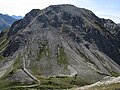
North side with entrenchments
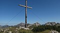
Summit cross

Entrenchments on the north flank


literature
- Zettler / Groth: Alpine Club Guide Allgäu Alps . Bergverlag Rudolf Rother, Munich 1984, ISBN 3-7633-1111-4
Web links
Individual evidence
- ^ Thaddäus Steiner : Allgäu mountain names . 2nd Edition. Kunstverlag Josef Fink, Lindenberg 2008, ISBN 978-3-8987-0389-5 (p. 177f).