
Schänzlespitze
| Schänzlespitze | ||
|---|---|---|
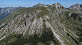
 Schänzlespitze seen from the northwest |
||
| height | 2052 m | |
| location | Bavaria , Germany / Tyrol , Austria | |
| Mountains | Vilsalpseeberge , Allgäu Alps | |
| Dominance | 0.5 km → Lahnerkopf | |
| Notch height | 113 m ↓ notch to the Lahnerkopf | |
| Coordinates | 47 ° 25 '23 " N , 10 ° 27' 24" E | |
|
||
| First ascent | by locals | |

The Schänzlespitze is a 2,052 m high mountain in the Allgäu Alps . It is located in the Rauhhornzug between the Lahnerkopf in the northeast and the Schänzlekopf in the southwest, exactly on the border between the municipal areas of Bad Hindelang in Bavaria and Weißenbach am Lech in Tyrol.
Origin of name
A first mention of the mountain was made in 1819 as Schänzlespitz in Uraufnahmeblatt the Royal Tax Survey Commission (SW 034-37). The name of the mountain is derived from a form of border fortification, the ski jump . One of these was built between Schänzlespitze and Schänzlekopf in the course of border disputes.
Before that, the mountains were probably called Alpatinspitzen , Weilandseck or Berengachtspitzen .
Ascent
There is no marked path leading to the Schänzlespitze. It can be reached easily from the Jubiläumsweg . The summit has no tourist significance.
photos
South flank

North flank

Entrenchments


literature
- Zettler / Groth: Alpine Club Guide Allgäu Alps . Munich, Bergverlag Rudolf Rother 1984. ISBN 3-7633-1111-4
Web links
Individual evidence
- ^ Thaddäus Steiner : Allgäu mountain names . 2nd Edition. Kunstverlag Josef Fink, Lindenberg 2008, ISBN 978-3-8987-0389-5 (p. 177f).