Schackendorf (Veilsdorf)
|
Schackendorf
Veilsdorf municipality
Coordinates: 50 ° 24 ′ 54 ″ N , 10 ° 49 ′ 27 ″ E
|
||
|---|---|---|
| Height : | 395 m above sea level NN | |
| Area : | 3.83 km² | |
| Residents : | 362 (Jun 30, 2008) | |
| Population density : | 95 inhabitants / km² | |
| Incorporation : | April 1, 1974 | |
| Postal code : | 98669 | |
| Area code : | 03685 | |
|
Location of Schackendorf in Thuringia |
||
Schackendorf is a district of Veilsdorf in the Hildburghausen district in Thuringia .
location
Schackendorf is not far from Veilsdorf on federal highway 89 in the southern foothills of the Thuringian Forest . Further east is Eisfeld , west Hildburghausen . By Werra Niederung passing railway Meiningen-Sonnenberg (Werrabahn). The border with Bavaria is not far away.
history
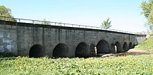
In the years 1330-1340, the district was first mentioned in a document. The year 1399 is assumed in the village. The affiliation of the village often changed. The stone Werra bridge was built in 1825 and the modern dairy cattle facility was built as the core object of Milch-Land-GmbH from 1974 to 1976.
Individual evidence
- ↑ a b History of Schackendorf on the website of the municipality of Veilsdorf ( Memento of the original from March 31, 2012 in the Internet Archive ) Info: The archive link was inserted automatically and has not yet been checked. Please check the original and archive link according to the instructions and then remove this notice. Retrieved April 13, 2012
- ^ Wolfgang Kahl : First mention of Thuringian towns and villages. A manual. Rockstuhl Verlag, Bad Langensalza, 2010, ISBN 978-3-86777-202-0 , p. 246
Web links
Commons : Schackendorf - Collection of images, videos and audio files

