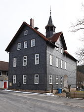
Goßmannsrod
|
Goßmannsrod
Veilsdorf municipality
Coordinates: 50 ° 25 ′ 58 ″ N , 10 ° 50 ′ 57 ″ E
|
||
|---|---|---|
| Height : | 412 m above sea level NN | |
| Area : | 5.47 km² | |
| Residents : | 395 (2012) | |
| Population density : | 72 inhabitants / km² | |
| Incorporation : | May 6, 1993 | |
| Postal code : | 98669 | |
| Area code : | 036878 | |
|
Location of Goßmannsrod in Thuringia |
||
Goßmannsrod is a part of the municipality Veilsdorf in the district of Hildburghausen in Thuringia .
location
Goßmannsrod is located on the eastern roof of the Hildburghausen Forest between Veilsdorf and Brünn on the state road 1136 in the hilly rural area. Two tributaries of the Werra touch the village, the Brünna and Weißa .
history
The village was first mentioned in documents in 1340. 395 inhabitants lived in the village in 2012. The residents are currently discussing the expansion of the memorial for the fallen men 1939–1945. The water lily pond in Weißagrund and the terraced hillside meadows are worth seeing.
Individual evidence
- ^ Wolfgang Kahl : First mention of Thuringian towns and villages. A manual. Publishing house Rockstuhl, Bad Langensalza. 2010, ISBN 978-3-86777-202-0 , p. 95
- ↑ History of Goßmannsrod on the website of the municipality of Veilsdorf ( Memento of the original from March 4, 2016 in the Internet Archive ) Info: The archive link was inserted automatically and has not yet been checked. Please check the original and archive link according to the instructions and then remove this notice. Retrieved April 13, 2012
Web links
Commons : Goßmannsrod - collection of images, videos and audio files

