Firing range trench
| Firing range trench | ||
|
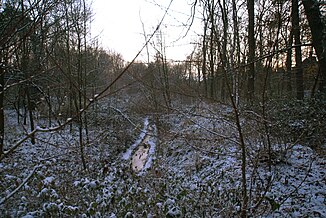
The frozen firing range trench |
||
| Data | ||
| location | Hamburg-Lurup , Hamburg-Bahrenfeld | |
| River system | Elbe | |
| Drain over | Mühlenau → Kollau → Tarpenbek → Alster → Elbe → North Sea | |
| source | East of Luruper Hauptstrasse, west of Altona main cemetery 53 ° 35 ′ 10 ″ N , 9 ° 52 ′ 48 ″ E |
|
| muzzle | south of the Farnhornstraße and east of the bright base path into a retention basin, which with the Kollau is connected coordinates: 53 ° 35 '32 " N , 9 ° 53' 58" O 53 ° 35 '32 " N , 9 ° 53' 58" O
|
|
| length | 1.2 km | |
| Left tributaries | Vorhorngraben , Lüttkampgraben | |
| Big cities | Hamburg | |
| Navigable | No | |
The shooting range ditch is a 1200 m long ditch in Hamburg-Lurup and Hamburg-Bahrenfeld . Its only tributaries are the Lüttkampgraben and the Vorhorngraben .
Firing range.
The name of the trench comes from the nearby shooting range on the Bahrenfeld Schulgartenweg. The firing range was laid out in 1860 by the Prussian Army and taken over by the police in 1950 . It was shut down in 2011.
Web links
Individual evidence
- ↑ Complete list of rivers in the Elbe catchment area. Retrieved June 30, 2020 .
- ↑ Thomas Hirschbiegel: Natural paradise turned into a crime scene: Dark secrets in Hamburg's largest park. July 23, 2019, accessed June 30, 2020 (German).
- ↑ a b c Hamburger Abendblatt- Hamburg: Shooting range at the Volkspark closes - areas contaminated. December 30, 2011, accessed June 30, 2020 (German).
