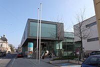
Shooting place ring
The Schießstattring is a street in St. Pölten that was named after the bourgeois shooting range before 1877 .
Location and characteristics
The Schießstattring is located on the western edge of St. Pölten's old town, just outside the city wall that existed until the middle of the 19th century. As a name outside the city walls at the site of today's served Stadtsäle standing Civil shooting range . Until 1934 today's almost parallel Julius-Raab-Promenade was also called the Schießstattpromenade . The street runs in a north-south direction from Europaplatz in the south and turns into Praterstrasse after the Westbahn underpass. It is part of Landesstraße 100 and forms one of the most important north-south axes in city traffic.
The construction on the west side was mainly built, on the east side partly in the second half of the 19th century.
Notable buildings
| object | Number / location | Explanation | image |
|---|---|---|---|
| Federal School Center |
Number 2 location |
The federal school center St. Pölten, consisting of HTBLuVA St. Pölten and HAK St. Pölten, is bordered by Andreas-Hofer-Straße, Schießstattring and Waldstraße, the latter provides the address of the complex. The St. Pölten military secondary school , which was destroyed in 1945, stood on the site of the center . The building, also known as the school barracks , was built in 1856, and the most famous student was probably Rainer Maria Rilke . | |
| City halls |
Number 4 location |
Some of the city halls are open to Völklplatz, which also provides the address.
The main building of the town hall was built in 1895 in late historicist style according to the plans of the St. Pölten architects and urban architect Richard Frauenfeld for KK priv. Schützenkompanie built, the north subsequent Banquet Hall tract is a group of 1882 established the Civil shooting range . The listed building was purchased by the city of St. Pölten in 1907 and adapted as an event location. It was converted into a 4-star hotel by 2011. |

|
| Regional and District Court |
Number 6 location |
The building of the regional and district court St. Pölten was built together with the directly adjoining correctional facility St. Pölten from 1901 to 1903. The then district court of St. Pölten is set back slightly to the rear of the building line. The three-storey building was the seat of the Soviet city command from 1945 to 1955 and was restored in 1957. Between 1992 and 1996 an extension wing was built by Paul Pfaffenbichler in Heßstraße . Work on an extension in Andreas-Hofer-Straße has been in progress since June 2009, and an underground car park is being built under the forecourt and the square is being redesigned. |

|
| Hesserkaserne |
Number 8-10 position |
The Hesserkaserne, named after Heinrich Freiherr von Heß, is the stationing place of the Lower Austria military command .
Today's Hesserkaserne was created in 1957 from the merger of three former Landwehr barracks . The Franz-Josephs-Kaserne, built in 1890, and the Rainerkaserne, built two years later, are located on Schießstattring, while the Eugenkaserne from 1900 is on the intersecting Heßstrasse. |

|
|
Number 11 location |
The building is on the corner of Schießstattring and Völklplatz, the latter provides the address. It was built by Emil Berger between 1898 and 1900 as his own house. The building used today by the ÖVP as a district office shows strong influences of the Secession style . | ||
|
Number 14 location |
The house was built in 1894, together with the building at Hötzendorfstrasse 1, by Friedrich Wohlmeyer in the late historical style. | ||
| Aquacity |
Number 15 location |
The municipal indoor swimming pool Aquacity was opened in 1966 and completely renovated between 2004 and 2005. |

|
| Evangelical parish church |
Number 19 location |
The Evangelical Parish Church and parsonage are located between Schießstattring, Julius-Raab-Promenade and Heßstraße. The neo-Gothic church was built between 1891 and 1892. The town's evangelical congregation had already acquired the property in 1872 and was only able to celebrate the church consecration two decades later due to a lack of financial means. There were originally three bells in the 36 meter high tower, only one of which survived the two world wars. |

|
| Luisenvilla |
Number 25 location |
The building called Luisenvilla stretches from Schießstattring over Ludwig-Stöhr-Straße to Julius-Raab-Promenade. It was built in 1891 by Richard Frauenfeld . | |
|
Number 27 location |
The former Hotel Habsburgerhof is now used as a residential building and is located on the corner of Ludwig-Stöhr-Straße, which also provides the address. The late historical building was built by Richard Frauenfeld in 1898 . |
literature
- Thomas Karl et al., 1999: The art monuments of the city of St. Pölten and its incorporated localities , ISBN 3-85028-310-0 , chapter Schießstattring , pp. 423–428
Web links
Individual evidence
- ↑ Manfred Wieninger , 2002: Tell St. Pöltner street names . Entry on Schießstattring , page 333. ISBN 3-7066-2208-4
- ^ Vienna City and State Archives , Ludwig Boltzmann Institute for Urban History Research (ed.), 1988: Austrian City Atlas - St. Pölten . 3rd delivery 1988, ISBN 3-7005-4588-6
- ↑ Rainer Maria Rilke / biography on xlibris.de
- ↑ Regional court receives extension , June 30, 2009 on st-poelten.gv.at
- ↑ Contact information ( page no longer available , search in web archives ) Info: The link was automatically marked as defective. Please check the link according to the instructions and then remove this notice. of the ÖVP St. Pölten