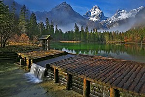
Schiederweiher
| Schiederweiher | ||
|---|---|---|

|
||
| Schiederweiher in the background Ostrawitz and Spitzmauer | ||
| Geographical location | Upper Austria | |
| Tributaries | Crooked Steyr | |
| Drain | Crooked Steyr | |
| Location close to the shore | Hinterstoder | |
| Data | ||
| Coordinates | 47 ° 41 '29 " N , 14 ° 7' 45" E | |
|
|
||
| Altitude above sea level | 612 m above sea level A. | |
| surface | 2.1 ha | |
| length | 200 m | |
| width | 170 m | |
| Maximum depth | 1.5 m | |
The Schiederweiher is an artificial lake created by the damming of the Krummen Steyr in the Polsterlücke in the Stodertal, Hinterstoder municipality . The lake is at an altitude of 612 m above sea level. A. below the Great Priel in the Dead Mountains .
description
The approximately 2 hectare pond is about 1 to 1.5 m deep. The inflow takes place via a ditch from the Krummen Steyr, in addition it is fed by springs in the pond bottom. The outflow into the Krumme Steyr is regulated by a wooden weir.
The ground is covered with sea chalk and overgrown with candelabrum algae and water cockfoot. On the south bank there is a contiguous strip of Großseggenried , the other banks are only partially covered with reed beds , and on the west bank there is a wet meadow. The pond is classified as oligotrophic .
history
The Schiederweiher was built from 1897 to 1902 by the kuk court architect Johann Schieder. In order to end the increasing algae and siltation of the pond, the lake was rehabilitated in 2004/05 by the municipality of Hinterstoder with the support of the landowner, the Duke of Württemberg .
After the renovation, which was carried out while protecting the reed belt and the shallow water areas, the fish population in the lake was rebuilt in 2005 with brook trout from the region, arctic char , chars , minnows , cops and crayfish .
In 2018, the Schiederweiher was voted the most beautiful place in Austria in the TV audience voting 9 Places - 9 Treasures .
leisure
- The purple path of Via Alpina leads past the Schiederweiher to the Prielschutzhaus .
- The 20 km long Flötzersteig leads from the Hinterstoder train station over the Stromboding waterfall , the chalk cave and the Schiederweiher to the origin of the Steyr.
Web links
- Schiederweiher - A landscape jewel has been renovated. Hinterstoder municipality, accessed on February 13, 2010 (with pictures of the renovation).
Individual evidence
- ↑ Digital Upper Austrian Room Information System (DORIS)
- ↑ a b c d e f Office of Upper Austria. Provincial government (ed.): Nature and landscape / models for Upper Austria. Volume 34: Steyr-Teichltal spatial unit. Revised Version, Krems and Linz 2007, p. 23, PDF (1.1 MB) on ZOBODAT
- ^ Office of Upper Austria. Provincial government (ed.): Mapping of natural areas in Upper Austria. Biotope mapping community Hinterstoder south-east and center. Final report. Kirchdorf an der Krems 2007, p. 66, PDF (9.5 MB) on ZOBODAT
- ↑ a b Display board at the lake, seen on February 1, 2010.
- ↑ Schiederweiher is the “most beautiful place” in Austria . In: ORF.at, published on October 26, 2018.
