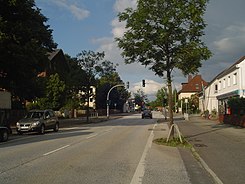
Schiffdorfer Chaussee
| Schiffdorfer Chaussee | |
|---|---|
| Street in Bremerhaven | |
| Basic data | |
| city | Bremerhaven |
| district | Geestemünde , Schiffdorferdamm |
| Newly designed | 1860 |
| Cross streets | At the mill , Hartwigstrasse, Feldstrasse, Vierhöfen, Seilerstrasse, Kammerweg, Walter-Delius-Strasse, Drosselweg, Georg-Büchner-Strasse, Kornweg, Im Felde, Ludwig-Börne-Strasse, Federal Motorway 27 , Carsten-Lücken-Strasse, Kuhhamm, Schwalbenweg, Veerenholzstraße, Gagelstraße, Hegerstraße, Eschackerstraße, Schiffdorfer Grenzweg, Vörtelweg |
| use | |
| User groups | Cars, bikes and pedestrians |
| Road design | two lane road |
| Technical specifications | |
| Street length | 2600 meters in Bremerhaven |
The Schiffdorfer Chaussee is a central access and thoroughfare in Bremerhaven , the Geestemünde districts (Bürgerpark) and Schiffdorferdamm . It leads in a west-east direction from the street An der Mühle and Hartwigstraße in Geestemünde to Schiffdorf (Bohlenstraße).
The cross streets and the connecting streets were often named after rural terms u. a. as An der Mühle after an earlier windmill (formerly Mühlenstraße), Hartwigstraße (?), Feldstraße, Vierhöfen, Seilerstraße after the job, Kammerweg (?), Walter-Delius- Straße after the former Lord Mayor of Wesermünde (1884-1945), Drosselweg , Georg-Büchner- Strasse after the writer (1813–1837), Kornweg, Im Felde, Ludwig-Börne -Strasse after the journalist and literary critic (1786–1837), Federal Motorway 27 , Carsten-Lücken-Strasse, Kuhhamm, Schwalbenweg , Veerenholzstrasse after an earlier wood that was cut in 1945/46 ( Vern , Verden or Fehren related to Furt or Furche), Gagelstraße, Hegerstraße, Eschackerstraße as field names, Schiffdorfer Grenzweg, Vörtelweg; otherwise see the link to the streets.
history
Surname
The Schiffdorfer Chaussee was named after the municipality of Schiffdorf to which it leads and which was first mentioned in 1139.
development
Schiffdorferdamm (still Geestendorferdamm until 1870 ) used to belong to the municipality of Schiffdorf. The first settlers came around 1780 and 1842. In 1860 the Schiffdorfer Chaussee was expanded. The "dam" became an urban suburb for workers. 1927 the incorporation took place with 1000 inhabitants to Wesermünde . In 2011 the place had 2,496 inhabitants.
The 64-hectare public park was laid out by 1908 . The hospital had been on Hartwigstrasse since 1905. A settlement community at the Bürgerpark was founded around 1949 and 282 apartments for around 600 residents were built by 1954. In 1962, the DRK hospital at the Bürgerpark opened.
traffic
This road connection already existed in the Middle Ages and was expanded in 1860. From 1947 to 1958 trolleybuses drove through the street to Schiffdorf.
In BremerhavenBus' local transport, lines 507 and 508 and the ML Moon-Liner run at night.
Buildings and facilities
The street has predominantly one to two-storey buildings.
Notable buildings and facilities
Geestemünde:
- No. 18: 1-sch. Shopping center with various shops
- No. 97 and Georg-Büchner-Straße No. 5 and 13: 1- to 3-gesch. Newer school center Carl von Ossietzky as a high school (CvO GyO) and vocational school for service, trade and design
- Ludwig-Börne-Strasse 2- to 8: 4- and 6-storey. newer house
- No. 138: 1-sch. shopping mall
- Federal motorway 27 to Bremen and Cuxhaven , junction Geestemünde
Schiffdorferdamm
- Carsten-Lücken-Strasse:
- 1-sch. Recreational home gaps
- Sports facilities from the SC Schiffdorferdamm
- No. 183: 2-storied red stone-faced school building from 1892, 1-storied Central building from 1956 and 3-tier. New building from 1967: the Veernschule as a primary school with around 180 students
- No. 202: 2-sch. Residential and commercial building with restaurant, shop and post office
- No. 227: 1-gesch. shopping mall
- No. 238: 1-gesch. Modern residential complex for the disabled of the Albert-Schweitzer-Wohnstätten eV from 1970 together with the Diakonisches Werk Bremerhaven
- Bohlenstrasse No. 54: 2-storey. Police station in Schiffdorf
literature
- Harry Gabcke , Renate Gabcke, Herbert Körtge, Manfred Ernst: Bremerhaven in two centuries; Volumes I to III from 1827 to 1991. Nordwestdeutsche Verlagsgesellschaft, Bremerhaven 1989/1991, ISBN 3-927857-00-9 , ISBN 3-927857-37-8 , ISBN 3-927857-22-X .
Individual evidence
- ^ Paul Homann: Bremerhaven route networks (public transport) since 1881 . In: BremerhavenBus website. Pp. 26-32.
Coordinates: 53 ° 31 ′ 45.2 " N , 8 ° 37 ′ 25.6" E
