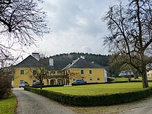
Hunnenbrunn Palace
Hunnenbrunn Castle (also: Hungerbrunn ) is a building in the Hunnenbrunn town of the same name, which today belongs to the municipality of Frauenstein in Carinthia . It was built in the second half of the 16th century in the Renaissance style, but has lost much of its original character through numerous additions and renovations. The listed building is now used by an agricultural college.
history
The name of the castle supposedly comes from the spring that rises here, which dried up in dry times and thus predicted a bad harvest - a so-called famine year. A rural homestead of the Hunnerbrunner family originally stood on the site of today's building. Originally part of the Kraig lordship , after the Kraigers died out in 1564 , the property passed to their heirs, the Counts of Hardegg zu Glatz and Machland. In 1570 Georg Freiherr von Khevenhüller acquired the estate and had a small castle built and decorated here instead of the farm. The property was owned by the Khevenhüller family until Baron Paul von Khevenhüller had to emigrate as a Protestant in the course of the Counter Reformation in 1619. Subsequently, the castle was mainly owned by St. Veit trades and civil families.
The Khevenhüller family was followed by the wealthy Zenegg trading family, in 1642 the imperial mint master Hans Georg Pero owned the castle, in 1659 his son Georg Balthasar von Pero sold the property to Johann Jakob Kärner, mayor and city judge of St. Veit. In 1671 Hans Christoph von Zenegg, the keeper of Taggenbrunn , took over the manor. In 1686 Franz Andreas von Mayerhoffen bought the castle and manor, which was now also equipped with a district court, and which remained in the possession of his descendants until 1806. After another change of ownership, Count Peter von Goëss acquired the castle in 1822, after which the owners changed in quick succession. Anton and Anna Eibl, who bought the palace in a foreclosure auction in 1876, had the name change from Hungerbrunn to Hunnenbrunn. In 1929 Josef Klimbacher was the owner of Hunnenbrunn, in 1943 the Deutsche Umsiedlungs- und Treuhandgesellschaft took over the castle for a short time, which had a new owner the following year, Walter Klimbacher.
In 1964, the state of Carinthia bought the property to set up a women's vocational school. In 1971 the extension facing away from the valley became necessary, and extensive restoration was carried out the following year. The castle is currently used by an agricultural college.
Building description
Castle and corner pavilion
The castle is located at the southwest exit of Hunnenbrunn on the road to St. Veit . It is shielded by a wall. The building is a small renaissance castle from the late 16th century. On the narrow sides of the two-storey building with a rectangular floor plan, two protruding round towers are attached, which are crowned by baroque onion helmets. The castle has largely lost its original character through renovations and modern additions. In the courtyard there are remains of a marble fountain with two male busts. The fountain, adorned with a Khevenhüller coat of arms and marked with the year "1585", was made by the builder of the Friesacher Stadtbrunnen. It was dismantled in 1948 and rebuilt in the courtyard of Karlsberg Palace .
In the former enclosing wall of the castle there is a baroque- style corner pavilion with an onion helmet to the south . The corner pavilion is a listed building along with the castle.
Meierhof
Immediately north of the castle is a baroque courtyard with a two-storey arcade courtyard. On the wall of the first floor there is a relief of an Antonius figure and a 1.20 meter wide fragment of a Roman tomb relief.
Wayside chapel
At the north entrance of the castle there is a path chapel built in the middle of the 18th century with a remarkable wrought iron grille and stone slab roof. In it was a crucifixion group carved by Johann Pacher , which is now kept elsewhere.
See also
literature
- Dehio Carinthia 2001 . Verlag Anton Schroll & Co., Vienna 2001, ISBN 3-7031-0712-X , p. 318.
- Siegfried Hartwagner : Carinthia. The St. Veit an der Glan district. (= Austrian Art Monograph, Volume VIII). Verlag St. Peter, Salzburg 1977, ISBN 3-900173-22-2 . P. 116.
Web links
- Entry via Hunnenbrunn Castle to Burgen-Austria
Coordinates: 46 ° 46 ′ 53.1 ″ N , 14 ° 22 ′ 20.2 ″ E


