
Sankt Veit an der Glan
|
Borough Sankt Veit an der Glan
|
||
|---|---|---|
| coat of arms | Austria map | |
 |
|
|
| Basic data | ||
| Country: | Austria | |
| State : | Carinthia | |
| Political District : | Sankt Veit an der Glan | |
| License plate : | SV | |
| Surface: | 50.79 km² | |
| Coordinates : | 46 ° 46 ' N , 14 ° 22' E | |
| Height : | 482 m above sea level A. | |
| Residents : | 12,386 (January 1, 2020) | |
| Population density : | 244 inhabitants per km² | |
| Postal code : | 9300 | |
| Area code : | 04212 | |
| Community code : | 2 05 27 | |
| NUTS region | AT213 | |
| UN / LOCODE | AT SVG | |
| Address of the municipal administration: |
Hauptplatz 1 9300 Sankt Veit an der Glan |
|
| Website: | ||
| politics | ||
| Mayor : | Martin Kulmer ( SPÖ ) | |
|
Municipal Council : ( 2015 ) (31 members) |
||
| Location of Sankt Veit an der Glan in the Sankt Veit an der Glan district | ||
  |
||
 Main square ("Oberer Platz") St. Veit an der Glan |
||
| Source: Municipal data from Statistics Austria | ||

|
Sankt Veit an der Glan ( city ) locality |
|
|---|---|
| Basic data | |
| Pole. District , state | Sankt Veit an der Glan (SV), Carinthia |
| Judicial district | Sankt Veit an der Glan |
| Pole. local community | Sankt Veit an der Glan ( KG St. Veit an der Glan , St. Donat ) |
| Coordinates | 46 ° 44 ′ 40 " N , 14 ° 18 ′ 42" E |
| height | 482 m above sea level A. |
| Residents of the village | 10,711 (January 1, 2020) |
| Building status | 2085 (January 1, 2011 ) |
| Statistical identification | |
| Locality code | 01662 |
| Source: STAT : index of places ; BEV : GEONAM ; KAGIS | |
Sankt Veit an der Glan (Slovene Sveti Vid or Šent Fid , sometimes with the addition of ob Glini ) is the name of both a municipality with 12,386 inhabitants (as of January 1, 2020) in Carinthia , Austria , and its largest town , the capital of Municipality, with 10,711 inhabitants (as of January 1, 2020).
The city emerged at the intersection of old traffic routes. It was the provincial capital of Carinthia until 1518, and it is the seat of the district administration of the political district of Sankt Veit an der Glan .
geography
Borough
The municipality is located in Central Carinthia, in the south of the Sankt Veit an der Glan district. In terms of landscape, it encompasses the east of the Glantal , the northeast of the Glantaler Bergland , the north of the Zollfeld and the west of the Launsdorf depression . In the north of the municipality, the main town lies at the foot of the Lorenziberg , just outside the town , and south of the main town are the Muraunberg, Hörzendorfer See and Tanzenberg. In the southwest the community extends to the eastern slope of the Ulrichsberg, in the southeast over the northern part of the Zollfeld to the western slope of the Magdalensberg.
main place
The city emerged at the intersection of old traffic routes: From the ancient connection from the Danube region to the Adriatic, which turns west at Sankt Veit towards Feldkirchen-Villach-Tarvis, roads branch south to Klagenfurt (and further via Loibl or Seeberg) and to East towards Völkermarkt and Görtschitztal with the old iron center Hüttenberg.
The city is located in the far west of the Glan Valley , on an alluvial cone at the confluence of Wimitz and Mühlbach in the Glan . In the past 150 years it has expanded in area in all directions, especially in the south-east towards the Zollfeld.
climate
|
Average monthly temperatures and precipitation for St. Veit an der Glan
|
|||||||||||||||||||||||||||||||||||||||||||||||||||||||||||||||||||||||||||||||||||||||||||||||||||||||||||||||||||||||||||||||||||||||||||||||||||||||||||||||||||||||||
structure
Structure of the community
Cadastral communities
The municipality comprises the following seven cadastral municipalities :
- Cadastral municipality of Galling
- Cadastral municipality Hörzendorf
- Niederdorf cadastral community
- Cadastral community project
- Cadastral parish of St. Donat
- Cadastral parish St. Veit an der Glan
- Cadastral community Tanzenberg
Localities
The municipality comprises the following 41 localities (residents as of January 1, 2020):
- Affelsdorf (20)
- Aich (5)
- Old England Village (95)
- Arndorf (6)
- Baardorf (4)
- Baiersdorf (28)
- Leg rats (11)
- Blintendorf (13)
- Dellach (50)
- Draschelbach (4)
- Eberdorf (4)
- Galling (8)
- Gersdorf (26)
- Wooden (13)
- Hörzendorf (374)
- Karlsberg (11)
- Karnberg (67)
- Laasdorf (4)
- Lebmach (0)
- Mairist (22)
- Milbersdorf (19)
- Muraunberg (73)
- Niederdorf (7)
- Plowing (16)
- Pörtschach am Berg (32)
- Preilitz (29)
- Projecting (47)
- Bike path (6)
- Raggasaal (7)
- Ritzendorf (15)
- St. Andrä (15)
- St. Donat (393)
- St. Veit an der Glan (10,711)
- Streimberg (2)
- Tanzenberg (4)
- Ulrichsberg (27)
- Unterbergen (92)
- Untermuehlbach (89)
- Unterwuhr (32)
- Wainz (5)
- Intermediate mountains (0)
Outline of the main town
Historically, today's capital St. Veit an der Glan was divided into the city (old town, inner city) and five suburbs (Friesacher Vorstadt, Klagenfurt Vorstadt, Villacher Vorstadt, Völkermarkter Vorstadt, Weitensfelder Vorstadt). The suburbs were temporarily (1869 and 1880) as separate localities, then as part of the locality. Today this subdivision no longer has any practical significance. Some of the former suburbs are eponymous for counting districts, but these do not coincide with the historical suburbs.
Old town
The old town surrounded by city walls (Innere Stadt, previously simply: city ) was built in the 12th / 13th centuries. Century created. The city around the Upper and Lower Square consisted of four quarters:
- To the north of Oberer Platz, around the town hall and along Judengasse (today Bräuhausgasse), there was the Vierzehn-Nothelfer-Viertel. It was named after the Nothelfer Church, which was demolished in 1790 and replaced by a residence that is now used as a district authority.
- The parish quarter with the parish church existed south of the Oberer Platz and around the Kirchgassl.
- To the north of Untere Platz (previously: Niederer Platz) and on Burggasse, there was the castle district with the so-called Herzogsburg.
- The Zwölfbotenviertel south of Unteren Platz and around Botengasse was named after the Zwölf-Boten-Kirche, which was demolished in the 18th century.
Friesacher suburb

In 1428 this settlement was called Friesacher Ort . In the 19th century, the Friesacher Vorstadt consisted of a few houses on Friesacher Straße leading east from the old town, including the Stern Gasthaus (at the location of today's Fuchspalast) and the Mailänderhof. In addition, the Kölnhof, the Ranftlhof, the Schönmühle on the Wimitz, the Theresienhof and the Marienhof on the road towards Kraig were counted as part of the Friesach suburb.
Klagenfurt suburb

Before the city was laid out as planned, St. Veit also extended southeast outside the city wall that was then built, around the area of today's country road. Near today's Evangelical Church there was the church of St. Johann im Erlach from the early 13th century at the latest. The settlement was later called St.-Johannes-Vorstadt (so in 1754).
In the 19th century, the Klagenfurter Vorstadt consisted primarily of houses along Klagenfurter Strasse and individual buildings in what is now Prinzhofer Strasse. Outside the closed development were the paper mill on the Glan, the white lead factory (used as barracks after closure at the end of the 19th century; today Funder-Villa) and above on the road to the Kollerhof the saltpeter plantation, on the loop at the mouth of the Wimitz and a little further down the Glan the city saw. In the area of the white lead factory and the large marshalling yard that was built in its vicinity, the name Glandorf was used from 1890 onwards.
Villach suburb

In 1321 the citizen hospital was founded west of the city - the building complex is still preserved today - two years later the Clarissin monastery next to it. After the monastery church of Our Lady , the settlement that was being built there was initially called Our Women's Place . In the 18th century the term Franziskaner Vorstadt appeared; the monastery church had become a Franciscan church in the 17th century. After the name Feldkirchener Vorstadt was used in the early 19th century, the name Villacher Vorstadt finally caught on. The Zeneggenhof trade center , which was demolished in 2003, was also important there .
Völkermarkter suburb

The Völkermarkter Vorstadt was the smallest and last mentioned of the five suburbs. In the 19th century, it comprised only a few houses close to the city on today's Völkermarkter Straße and far outside, near the Wimitz, the Weyer Castle, the Rassnigmühle and the decking kitchen.
Weitensfeld suburb

Already in the 14./15. In the 19th century, the area of today's Rechtsgasse and between Obermühlbacher Straße and Erlgraben (Mühlbach) was built. In the Döber there were trade headquarters , from the 17th century a noblemen's seat . A military hospital or military hospital appeared here in the 18th century and, from the early 19th century, a bathhouse. The settlement was at times also called the hospital district or - after the Loretto Church built in the 17th century and later the Kalvarienbergkirche - as the Loreto district or the district under the Calvaryberg .
Breakdown according to counting groups
For statistical purposes the municipality is divided into five census districts, these in turn in census districts. The counting districts 00, 01 and 02 include the main town, the counting districts 03 and 04 the rest of the municipality. The boundaries of the census districts do not coincide with the historical boundaries of the suburbs, even if their names are used:
-
00 old town
- 000 St.Veit adGlan old town : the walled old town as well as the houses in the area of the former barbican directly in front of the former Friesachertor and the former Villachertor .
-
01 Inner city area : the area of the city northwest of the railroad, excluding the old town
- 010 Weitensfelder Vorstadt : the northernmost part of the city, bounded to the south by (from west to east) Urtlstrasse-Spitalgasse-Lindengasse-Grabenstrasse-Friesacher Strasse-Sandgasse
- 011 Friesacher Vorstadt : the area of the city between Friesacher Strasse and the railway; ends out of town at the junction of Friesacher Straße and Bahnstraße.
- 012 Klagenfurter Vorstadt : the area bordering the old town to the southeast between Prinzhoferstrasse and Völkermarkter Strasse; bounded out of town by the railway.
- 013 St.Veit-Marktwiese : the area of the city between Villacher Straße-Ossiacher Straße and the Rudolfsbahn; from Prinzhoferstraße in the east to the edge of the cadastral parish St. Veit an der Glan in the west; In addition, a small area north of Villacher Strasse with apartment buildings in the Jägersteig - Hubertusstrasse area.
- 014 St.Veit-Villacher Vorst .: The area of the city north of Villacher Strasse (except for a small area with apartment buildings in the Jägersteig - Hubertusstrasse area); bounded to the east and north by Altstadt-Lindengasse-Spitalgasse-Urtlstrasse.
-
02 Outer urban area : the area of the city southeast of the railroad
- 020 St.Veit-Glanbogen : the easternmost part of the city, from Weyerfeld in the north to the southern border of Glandorf in the south, bounded to the west by the railway.
- 021 Sankt Veit-Süd : the area in the south-west of the city between Glan and Rudolfsbahn; ends to the northeast at the Gleisdreieck.
- 022 Muraunberg : the area of the city south of the Glan and west of the Rosentalbahn.
-
03 St. Donat: corresponds to the area of the former municipality of St. Donat with the exception of the area of the former village of Neuglandorf.
- 030 St. Donat
-
04 Hörzendorf : corresponds to the area of the former municipality of Hörzendorf and the villages of Karnberg and Eberdorf (formerly part of the municipality of St. Peter am Bichl)
- 040 Hörzendorf
history
Antiquity
On the Gratzerkogel am Zollfeld, on the southern edge of what is now the municipality, there was a fort in Roman times. In the 5th century a settlement with a bishopric was built in its place, which was abandoned around 600.
City foundation

The earliest evidence of a settlement in the area of today's city in the narrower sense is the fragment of an early medieval Carolingian wickerwork stone, which can be seen in a second use in the outer wall of the Karner near today's parish church . According to legend, an incursion by the Hungarians in 901 was the reason for the founding of the city: St. Vitus appeared to a carantan duke named Rathold at a battle near Hungerbrunn north of today's city and gave him courage. After a victorious battle on the battlefield, the duke cleared an alder thicket and had a church built at this point, around which the city gradually arose.
A settlement was initially created in the area between the location of today's parish church and the church of St. Johann im Erlach (which was located near today's Evangelical Church), along the course of the Mühlbach at that time; In the area of today's city center there was probably a stately courtyard at that time. In 1122 the Spanheimers succeeded the Eppensteiners as dukes of Carinthia ; St. Veit gained importance among them. Today's parish church was built. 1147 sold Margrave Engelbert III. (Spanheim) transferred the court to St. Veit to the diocese of Bamberg , but the purchase was soon reversed. St. Veit quickly became the center of the ducal property in Carinthia, which initially resided in the nearby Freiberg Castle , just outside of today's municipal boundaries.
Ducal residence, capital of Carinthia

In the late 12th century, the seat of the dukes was gradually moved from Freiberg Castle to St. Veit, which was named the forum (market) in 1199 . The place experienced its first heyday under Duke Bernhard von Spanheim (1202–1256), the son-in-law of King Ottokar of Bohemia . In 1204 a school was mentioned. From 1205 the ducal coin stood in St. Veit (until 1725), in which the oldest surviving coin with a German inscription was minted in 1220. In 1224 St. Veit received city rights with its own judge and twelve jury members (councilors). Bernhard had city walls built and he built the castle in St. Vitus, which is documented as a fort or palace , while a ring of castles existed on the hills around the city. Bernhard led a splendid court management: he introduced the hereditary court offices of cupbearers, truchess and marshals. In 1214 Walther von der Vogelweide stayed in St. Veit. In 1277 Ulrich von Lichtenstein fought here in the tournament. After the Spanheimers died out (1269), Meinhard II of Görz-Tirol became Duke in 1286 , and the castle and town were badly damaged in the ensuing uprisings in 1293; the city walls were then renewed. In the 1320s the Citizens Hospital and the Clariss Convent were founded.
For the Counts of Görz-Tirol, St. Veit was only a secondary residence. When the Duchy of Carinthia in 1335 fell to the Habsburgs, St. Veit lost, although its importance as a residence final, the princely authorities, however, were developed: there was Hoftaiding and land Schranne , county judge, steward and the princely Vizedom in the city. Meetings of princes took place in the city in 1360 and 1374. From 1450 the place was officially designated as the “capital”. Between 1473 and 1492 there were five Turkish incursions into the area around the city, and in 1480 the suburbs were damaged during a siege by the Hungarians. In the 15th century the nobility and clergy had gained in importance in the country; after the country's troops, who wanted to put down a peasant uprising in northern Carinthia, were prevented from passing through the city by the city of St. Veit in 1516, the country's estates intervened with the emperor against the city. This led to Emperor Maximilian I handing Klagenfurt over to the state estates in 1518 in order to weaken the importance of St. Vitus, and Klagenfurt gradually expanded and assumed the functions of a capital.
Reformation and Counter-Reformation; Iron, trade

In the 1520s, the aristocratic arsenal (later incorrectly called "Duke's Castle") was built on the northeast corner of the city. Some castles in the vicinity of the city were rebuilt or expanded in the 16th century, in today's municipality this applies to Weyer Castle, Karlsberg Castle, Stadlhof Castle, Niederdorf Castle and Kölnhof Castle. But the estate authorities gradually moved to Klagenfurt.
The traders and tradesmen stayed in St. Veit. As early as 1362 the city was given a meadow market by Rudolf the founder , which is still held annually today. From 1547 a mayor was elected annually. The country's first paper mill was built here in 1550 . In 1653 the city was granted another market, the "Cold Market". The city's importance as a traffic junction and trading center gradually declined because the route via Graz and Trieste gained in importance as a connection from the Adriatic to the Danube countries at the expense of the older connection via St. Vitus and Tarvisio
Even though Klagenfurt had become the seat of the estates, St. Veit continued to emphasize its role as a princely city. In St. Veit, the church Reformation movement of the 16th century had to fight with more resistance than in the surrounding area due to the Catholic sovereign influence. Around 1600 the re-Catholicization of the citizens was enforced; the satellite guard, which protected the monstrance at Catholic festivals and processions, gained in importance. In the 17th century the Franciscans were settled in the former Clariss convent; The Maria Loreto Church was built above the town.
In 1399 the city got the right to deposit iron from the Hüttenberger Erzberg , which allowed trade and thus the whole city to flourish. In 1578 the St. Veitern in der Urtl near Guttaring built a modern blast furnace . The iron industry was accelerated in the 18th century. In the years 1713 and 1715 the plague raged in St. Veit, in 1747 the town burned down. In 1783 Joseph II revoked the city's trade privileges, which ultimately led to economic decline. The Josephine reforms also led to the end of regional carving; Johann Pacher , Johann Georg Hittinger and their colleagues had furnished many churches in Carinthia from St. Veit in the 18th century.
railroad
_0838.jpg)
In 1830 the city had only 1500 inhabitants after it had had 3000 inhabitants in the Middle Ages. With the construction of the Rudolfsbahn in the 19th century and the beginning of the timber trade, an economic recovery began. The train station was initially built quite far to the south of the city and at the end of the 19th century led to rapid growth in the Klagenfurt suburb. In 1912 the new main train station was built in the west of Sankt Vitus, in the Friesach suburb. St. Veit became a "railway town".
From 1850 until the outbreak of war in 1914 there was a permanent garrison in St. Veit, initially consisting of a squadron of lancers, then dragoons and finally hussars. They were initially housed in the city center; from the end of the 19th century in the then closed lead factory in the Klagenfurt suburb. In 1877 the Merciful Brothers founded the hospital in the Weitensfeld suburb.
First and Second World War
After the First World War, the SHS state occupied large parts of Carinthia. In June 1919, Italian troops protected St. Veit from militants attacking from the south. The Völkermarkt district administration was temporarily relocated to the unoccupied St. Veit, as was the seat of the Carinthian provincial government in the summer of 1919, which was only able to return to Klagenfurt in late autumn 1920.
National Socialists were active in the St. Veit area long before the annexation to the German Reich ; the later Gauleiter Friedrich Rainer joined the SA in 1923 . During the Nazi coup attempt in 1934, around 900 armed men succeeded in taking over the city. This was followed by heavy fighting around St. Veit, with 13 dead. During the Second World War, the library of the High School of the NSDAP was moved from Berlin to Tanzenberg Castle . But there was also resistance to National Socialism, especially among the railway workers; Maximilian Zitter and nine other railroad workers were executed in 1942.
Enlargement of the municipal area
The township established in the course of the administrative reforms after the revolution of 1848/49 initially only included the cadastral parish of St. Veit an der Glan, i.e. the old town with its five suburbs. In 1958 the parish of St. Donat was attached. This merger made it easier to supply the Glandorf settlement, which had grown rapidly in the decades before on both sides of the border between the communities of St. Veit and St. Donat, next to the large marshalling yard and the Funderfabrik, with the necessary infrastructure. In 1962, 12 hectares of land came from the municipality of St. Georgen am Längsee to the municipality of St. Veit; the affected area (today the area around the house at Flussgasse 150) could only be reached from the St. Veiter area due to the Glan regulation.
In 1972 the municipality of Hörzendorf , in which a central location could never emerge, was attached to St. Veit, including the parish and school locations Hörzendorf and Projern as well as Tanzenberg Castle with its grammar school at St. Veit. In 1973 a small part of the parish of St. Peter am Bichl came to St. Veit. Through all of these expansions, numerous small villages became part of the township; the area of the municipality of St. Veit increased fivefold within 15 years, but the number of inhabitants only grew by about a fifth due to the incorporation.
present
At the turn of the millennium, the city first tried to position itself as a “city of flowers”. Accordingly, the flower hall and flower hotel were built. On the other hand, an industrial center was built on the southern outskirts of the municipality, near Blintendorf. The settlement of companies such as Kioto Solar and Greenonetec contributed to the fact that Sankt Veit seeks to make a reputation for itself as a “city of the sun”.
A major challenge for the municipality is to maintain sufficient customer frequency for the shops in the picturesque old town despite the construction of numerous supermarkets and specialist markets and shopping centers on the outskirts.
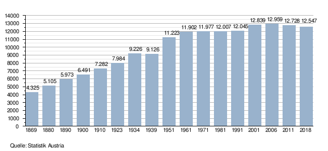
population
According to the 2001 census, Sankt Veit has 12,839 inhabitants, 92.5% of whom are Austrian, 2.3% Yugoslav and 2.2% Bosnian citizens. 74.0% of the population profess the Roman Catholic , 8.6% the Evangelical Church and 4.3% are of the Islamic faith; The Jehovah's Witnesses have a Kingdom Hall in Sankt Veit. 10.2% of the population are without religious belief.
Population development
Culture and sights
Old town
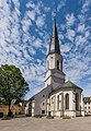
- The old town with dimensions of about 380 × 200 m is surrounded by the largely preserved city wall. Almost all of the houses in the old town have medieval core; many of the town houses around the two town squares have arcaded courtyards.
- The late Gothic town hall Sankt Veit an der Glan (a three-storey, six-axis building with a keel arched portal, elaborately designed facade and arcade courtyard), a plague column (1715/16) and two fountains ( Vogelweide fountain ) are located on the main square, which is around 200 by 30 m and bowl well).
- The Catholic parish church of Sankt Veit an der Glan , first mentioned in a document in 1131, is a large, in its basic features late Romanesque and in its present form late Gothic choir tower church. The current exterior is based on a thorough restoration after a fire in 1829. On the west wall there are several grave monuments from the 15th to 18th centuries. The Karner St. Michael south of the parish church at the former cemetery is essentially a Romanesque rotunda from the 13th century (mentioned in documents in 1275 and 1359) and was previously used as an ossuary . Since 1930 it has served as a war memorial.
- The so-called Herzogsburg , actually a former sovereign arsenal, is used for cultural events (concerts, vernissages, theater).

Arcade courtyard of the town hall
Catholic parish church

Karner

Walther-von-der-Vogelweide fountain in the main square


Other urban area
- The former civic hospital with the profaned hospital church , first mentioned in a document in 1321, is located west of the old town in front of the former Villacher Tor.
- The monastery church of Our Lady southwest of the former citizens' hospital was mentioned in a document in 1323 as the church of a Poor Clare monastery founded by Konrad von Auffenstein and his wife Diemut. The church was consecrated again in 1648 after the monastery was renovated and restored in 1963/64. The monastery, last owned by the Franciscans, was abolished in 1768 by Emperor Joseph II, partly demolished in 1863, today used for residential purposes.
- The Maria Loretto Calvary Church , mentioned in a document in 1658, stands on a hill northwest of the city center.
- The castles Kölnhof and Weyer on the northeast and eastern outskirts are privately owned and used as a business location and for residential purposes.
- The main train station is an elongated, one to two-storey building in the late historical style built by Hans Granichstaedten between 1911 and 1913. The representatively designed terminal building has a steep roof with an ornamental gable and a protruding bell tower with an ornamental cornice and an octagonal lantern attachment . The iron platforms are from the construction period.
Rural area of the municipality
- The parish churches of Hörzendorf , Projern, St. Donat and the subsidiary churches of Karnberg, St. Andrä and Streimberg are located in the villages belonging to the municipality ; Roman stones and wickerwork stones are walled into some of them.
- The mighty Tanzenberg Castle far to the south of the municipality above the Zollfeld goes back to a Renaissance castle with an older core, was renovated at the beginning of the 20th century and supplemented by a neo-Romanesque pillar basilica, and serves as a school building.
- The ruins of Karlsberg Castle, hidden in the forest, are the only castle of the former castle wreath around the city that is located in today's St. Veiter municipality.
- The castles Niederdorf (Renaissance building from the 16th century), Karlsberg (built in the 17th century), Stadlhof (built around 1780 over the older core) are all privately owned and used for residential purposes.

Tanzenberg Parish Church and Tanzenberg Castle

Niederdorf Castle


Modern architecture
- The Ernst Fuchs Palace is a controversial hotel building designed by Ernst Fuchs .
- Industrial architecture FUNDER Plant 3 by Coop Himmelblau , natural project “Nature must grow”, St. Donat district
- Façade and Fundernovum by Günther Domenig FunderMax Plant II in the Glandorf district
- The flower hall, in which events of all kinds are held

Ernst Fuchs Hotel in Sankt Veit an der Glan

FUNDERMAX plant II in Oberglandorf (conversion by Günther Domenig , 1987)


- Museums
- Museum Sankt Veit an der Glan : The Museum of Transport and City History on the main square in Sankt Veit was created in 2003/2004 as a combination of several previous institutions such as B. the town museum in the castle (founded in 1886), the satellite museum in the former citizen hospital and the transport museum (founded in 1982) in the town hall and then in the former housekeeping school (from 1987). The St. Veit Museum is run jointly by the St. Veit Transport Museum and the St. Veit municipality. It presents over 3000 exhibits on the history of traffic, post and telecommunications and the history of the city on an area of 1000 m² on three floors. It is closed from November 1st to March 30th.
- The museum heating house of the Nostalgiebahnen in Carinthia (NBiK) is located at St. Veiter Westbahnhof .
Regular events
- Veitsmarkt since 1170
- St. Veiter Wiesenmarkt since 1362 - one of the largest and oldest folk festivals in Austria
- Cold market since 1653
- Easter market since 1844
- Trigonale since 2003 - Festival of "old" music
- St. Veiter Literature Days (annually in November)
Economy and Infrastructure
Established businesses
FunderMax's wood panel production is located in St. Veit an der Glan.
The headquarters of the watch manufacturer Jacques Lemans , who among other things also exclusively produces the watches for Formula 1 . For the purpose of signing the contract with Jacques Lemans , Formula 1 boss Bernie Ecclestone was in St. Veit.
In the St. Veit / Glan industrial park, the focus on the solar industry has developed around the leading companies located there . Companies in the industrial park (selection):
- Druck Carinthia GmbH, a company of the Styria Media Group
- General Solar Systems GmbH
- GREENoneTEC Solarindustrie GmbH
- KIOTO Photovoltaics GmbH
- impress decor Austria GmbH
"Sun City" St. Veit an der Glan
In 2010 the project Sonnenstadt St. Veit started in St. Veit . The vision of the city policy is for St. Veit to achieve complete energy self-sufficiency through renewable energy by 2020 . In order to achieve this ambitious goal, the construction of Austria's largest photovoltaic power plant with an output of 1,500 KWp and an annual generation of around 1.5 million kilowatt hours began in 2010 . An investment amount of € 6.8 million was estimated for this pilot project . By 2013, a total photovoltaic area with an output of more than 3 megawatts peak was created in the city area.
Of the three in the industrial park settled solar energy -Unternehmen located with GREENoneTECH GmbH a " secret world leader " in the solar industry.
traffic
Railway lines from three directions - Friesach, Feldkirchen and Klagenfurt - meet in St. Veit . St. Veit / Glan is also a long-distance traffic stop. Trains on the Vienna - Villach line stop every two hours.
St. Veit is an important junction for the Carinthia S-Bahn . Since December 12, 2010 the S1 line has been running every half hour to Klagenfurt and every hour to Friesach on weekdays . Since December 2011 St. Veit has been the starting and ending point of the S2 line to Feldkirchen , Villach and Rosenbach .
politics

City Councilor and Mayor
The city council (city government) of St. Veit has seven members. Mayor was Gerhard Mock (SPÖ) from 1989 to 2020 , since 2020 Martin Kulmer.
- 1989–2020: Gerhard Mock (SPÖ)
- since 2020: Martin Kulmer (SPÖ)
Municipal council
The municipal council consists of 31 members and has been composed as follows since the 2015 municipal council election :
Town twinning
- Sundbyberg (Sweden), since 1971
- Haltern am See (Germany), since 1972
- Épinay-sur-Seine (France), since 1985
- Mainz-Kostheim (Germany), since 1989
- San Vito al Tagliamento (Italy), since 1989
coat of arms
The use of a seal can be proven for St. Veit since 1269 (mentioned on May 15, 1279), and received in a document dated October 3, 1281. While in this version the patron saint is only shown in a two-line inscription, a few years later a seal with the bust of the saint was used in an archway flanked by a pair of towers. From the 16th century, the depictions showed the town's patron sitting in a cauldron with his hands folded, but in 1900 the old depiction from the late thirteenth century was reverted to, which the township formally accepted by a local council resolution on July 4th, 1961.
The official blazon of the city coat of arms is as follows:
- In the blue shield one of two silver, black roughened (latticed) arches flanked by a double Romanesque towers in the middle with a simple water serpentine cornice and studded with a golden ball, which shows the bust of Saint Vitus in a red choir skirt, white shirt Enclosed with a golden (yellow) stole and golden halo. In the right hand the saint holds a large palm branch, while the left hand is raised in blessing. Above the black roughened (latticed) archway with the inscription S. Vitus and decorated with a golden ball are two golden stars.
The flag is white-blue-yellow with an incorporated coat of arms.
Personalities
sons and daughters of the town
- August Prinzhofer (1817–1885), born and raised in St. Veit, worked as a painter and lithographer in Vienna and Graz
- Josef Lemisch (1862–1918), born and raised in St. Veit, worked as a politician (member of the Carinthian state parliament; deputy governor) in Klagenfurt
- Arthur Lemisch (1865–1953), born and raised in St. Veit, lived here at Kölnhof Palace; Politician (1918–1921 provincial administrator and 1927–1931 provincial governor of Carinthia)
- Sebastian Weberitsch (1870–1946), born and raised in St. Veit, worked as a doctor and writer (described in detail his childhood in St. Veit in his main work) in Bozen and Baden near Vienna
- Hermann Knaus (1892–1970), born and raised in St. Veit, worked as a gynecologist (co-developer of the Knaus-Ogino calendar method) in Graz and Prague
- Martin Rom (1895–1970), born and raised in St. Veit, politician (SPÖ member of the National Council, Mayor of St. Veit)
- Ottilie Schellander (1897–1967), head nurse in the infirmary and lunatic asylum of the Carinthian State Hospital in Klagenfurt and involved in euthanasia
- Friedrich Rainer (1903–1947), born and raised in St. Veit, politician (co-founder of the NSDAP local group St. Veit; Gauleiter of Salzburg and Carinthia in the Third Reich)
- Karl Paul Gebhardt (1905–1941), born and raised in St. Veit; Politician (NSDAP Reich Staff Member)
- Heinz Lienhard (1922–1999), born and raised in St. Veit, worked here as a poet
- Herwig Hofer (1940-2013), born and raised in St. Veit, worked from here as a politician (ÖVP; city council; member of the Federal Council, member of the state parliament)
- Karl Garnitschnig (* 1941 in St. Veit), works as a pedagogue, psychotherapist and educational theorist in Vienna
- Heinz Trixner (* 1941 in St. Veit), works as an actor and speaker in Vienna, Salzburg, Germany and Switzerland
- Libgart Schwarz (* 1941 in St. Veit), works as an actress in Berlin and Vienna; Ex-wife Peter Handkes
- Karl Starzacher (* 1945 in St. Veit), grew up in Germany, active there as a politician (SPD; Hessian state parliament president and finance minister)
- Elisabeth List (1946–2019), born in St. Veit; Philosopher
- Dieter Themel (* 1946 and grew up in St. Veit), musician
- Wolfgang Puck (* 1949 and grew up in St. Veit), active as a cook and catering entrepreneur in the USA
- Gerhard Mock (* 1953 and grew up in St. Veit), worked here as a politician (SPÖ; member of the state parliament; 1988-2020 mayor of St. Veit)
- Dagmar Obernosterer (* 1959 and grew up in St. Veit) works here as a songwriter
- Antonia Gössinger (* 1958 in St. Veit), works from Liebenfels as a journalist (editor-in-chief of the Kleine Zeitung)
- Franz Wohlfahrt (* 1964 and grew up in St. Veit), worked as a football player from Vienna and Germany (ÖFB national team goalkeeper, DFB cup winner)
- Bernhard Loibner (* 1965 in St. Veit), works from Vienna as a composer and musician
- Arnulf Prasch (* 1965 in St. Veit; grew up in Passering), active from Villach as an ORF radio and television presenter
- Manfred Krassnitzer (* 1968), from St. Veit, was active as a football referee throughout Austria
- Michaela Kohlweiß (* 1973 in St. Veit), State Police Director of Carinthia
- Andy Kainz (* 1974 in St. Veit), professional dancer
- Markus Schauta (* 1976 in St. Veit), Middle East journalist and author
- Johannes Kirisits (* 1985 in St. Veit) worked as an ice hockey player in Klagenfurt
- Manuel Kerhe (* 1987 in St. Veit), works in Carinthia and Austria as a football player (Bundesliga)
- Magdalena Lobnig (* 1990 in St. Veit), works from Völkermarkt as a rowing athlete (EM and World Cup medalist)
- Matthias Mayer (* 1990 in St. Veit), works from Afritz am See as a ski racer (Olympic champion 2014 and 2018)
- Marco Haller (* 1991 in St. Veit), works from Klagenfurt as a cyclist (multiple Austrian champion)
- Martin Hinteregger (* 1992 in St. Veit), grew up in Albeck, works from Germany as a football player (ÖFB national team defender)
- Adrian Pertl (* 1996 in St. Veit), active as a ski racer from Ebene Reichenau
Personalities associated with the city
- Simerl Krapfenbäck (1785–1809), born in Möderndorf, grew up in St. Veit; Robber, social rebel
- Johann Mathias von Koller (1727 / 28–1805), moved to St. Veit as a young adult; Iron merchant and industrialist, mayor of St. Veit
- Gerhard Glawischnig (1906–1995), born in Kreuth near Rattendorf, worked as a dialect poet and Protestant pastor in St. Veit and Villach
- Käthe Kainz (1913–1996), born in St. Pölten; Politically active from St. Veit from 1947 (SPÖ; member of the Federal Council)
- Hans Sima (1918–2006), born in the Canal Valley; grew up and buried in St. Veit, politician (SPÖ, 1965–1974 Governor of Carinthia)
- Dieter Kalt senior (* 1941), born in Klagenfurt; District captain in St. Veit 1982-2006
- Peter Legat (* 1958 in Klagenfurt), musician, founder of Count Basic
literature
- Andreas Besold: St. Veit an der Glan . Heyn Verlag, Klagenfurt 1997, ISBN 3-85366-840-2
- Siegfrid Hartwagner: The St. Veit an der Glan district. His works of art, historical forms of life and settlement. (= Austrian art monograph, Volume 8) Verlag St. Peter, Salzburg 1977, ISBN 3-900173-22-2 , pp. 206-219.
- City of St. Veit / Glan (ed.): The St. Veit city book. Posts, memories, anecdotes . Self-published by the municipality, St. Veit an der Glan 1991.
- Fidelis Widmann, Fritz Kimeswenger (ed.): St. Veit an der Glan. Big story in little stories . Context-Verlag, St. Veit an der Glan 2007, ISBN 978-3-902492-14-2 .
- Friederun Pleterski : Traveling home. In the footsteps of my family. Styria Publishing Group, 2012, ISBN 978-3-7012-0100-6
Web links
- City of Sankt Veit an der Glan
- 20527 - Sankt Veit an der Glan. Community data, Statistics Austria .
Individual evidence
- ^ Eberhard Kranzmayer: Place name book of Carinthia. History Association for Carinthia, 1956. p. 187.
- ↑ Statistics Austria: Population on January 1st, 2020 by locality (area status on January 1st, 2020) , ( CSV )
- ↑ Statistics Austria: Population on January 1st, 2020 by locality (area status on January 1st, 2020) , ( CSV )
- ↑ a b c d e f g St. Veit / Glan . Austrian city atlas.
- ↑ a b c d e STATatlas
- ^ Founding legend according to Hartwagner: The district of St. Veit an der Glan , Salzburg 1977, p. 206
- ↑ Statistical information based on municipal data , as of 2001 census from Statistics Austria
- ↑ Dehio Kärnten , Vienna 2001, pp. 841–844
- ↑ Dehio Kärnten , Vienna 2001, pp. 844ff.
- ^ Hotel Ernst Fuchs Palast
- ↑ a b St. Veit has a new mayor. In: ktn.gv.at. April 22, 2020, accessed April 23, 2020 .
- ↑ Office of the Carinthian State Government ( page no longer available , search in web archives ) Info: The link was automatically marked as defective. Please check the link according to the instructions and then remove this notice. , accessed March 20, 2009
- ^ Carinthia: St. Veit has a new mayor. In: regionews.at. April 23, 2020, accessed April 23, 2020 .
- ↑ St. Veit Municipal Council , accessed on January 1, 2017
- ↑ In fact, the St. Veiter SPÖ has 17 mandates, since a Green Municipal Council switched to the SPÖ in November 2017. See also the Carinthian General Municipal Code §21 (7) , accessed on January 28, 2020
- ↑ Received on documents from 1296 and 1492. These and other typars and their replicas are in the St. Veiter City Museum.
- ↑ Quoted from Wilhelm Deuer: The Carinthian municipal coat of arms . Verlag des Kärntner Landesarchiv, Klagenfurt 2006, ISBN 3-900531-64-1 , p. 258.

Cadastral communities: Galling | Hörzendorf | Niederdorf | Projecting | St. Donat | St. Veit an der Glan | Tanzenberg
Locations: Affelsdorf | Aich | Altglandorf | Arndorf | Baardorf | Baiersdorf | Leg rats | Blintendorf | Dellach | Draschelbach | Eberdorf | Galling | Gersdorf | Wood | Hörzendorf | Karlsberg | Karnberg | Laasdorf | Lebmach | Mairist | Milbersdorf | Muraunberg | Niederdorf | Plowing | Pörtschach am Berg | Preilitz | Projecting | Bike path | Raggasaal | Ritzendorf | St. Andrä | St. Donat | St. Veit an der Glan | Streimberg | Tanzenberg | Ulrichsberg | Unterbergen | Untermühlbach | Unterwuhr | Wainz | Between mountains
Former localities: Glandorf | Höfern | Neuglandorf | Prikalitz
(Former) parts of the village: Stadlhof | Strolz
Former suburbs: Friesacher Vorstadt | Klagenfurt suburb | Villach suburb | Völkermarkter Vorstadt | Weitensfeld suburb
Counting districts and districts: 00 Old town: 000 St. Veit an der Glan old town | 01 Inner city area: 010 Weitensfelder Vorstadt | 011 Friesacher Vorstadt | 012 Klagenfurt suburb | 013 St. Veit-Marktwiese | 014 St. Veit-Villacher-Vorstadt | 02 Outer city area: 020 St. Veit-Glanbogen | 021 Sankt Veit-Süd | 022 Muraunberg | 03 St. Donat: 030 St. Donat | 04 Hörzendorf: 040 Hörzendorf
Former communities: Hörzendorf community | Saint Donat parish
Althofen | Brückl | German handles | Eberstein | Frauenstein | Friesach | Glödnitz | Cucumber | Guttaring | Hüttenberg | Kappel am Krappfeld | Little Saint Paul | Liebenfels | Metnitz | Micheldorf | Mölbling | Sankt Georgen am Längsee | Sankt Veit an der Glan | Strasbourg | Weitensfeld in the Gurktal