
Eberdorf (municipality of St. Veit an der Glan)
|
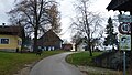
Eberdorf ( isolated settlement ) locality |
|||
|---|---|---|---|
|
|||
| Basic data | |||
| Pole. District , state | Sankt Veit an der Glan (SV), Carinthia | ||
| Judicial district | Sankt Veit an der Glan | ||
| Pole. local community | Sankt Veit an der Glan ( KG Projern ) | ||
| Coordinates | 46 ° 42 '38 " N , 14 ° 17' 5" E | ||
| height | 645 m above sea level A. | ||
| Residents of the village | 4 (January 1, 2020) | ||
| Building status | 3 (January 1, 2011 ) | ||
| Statistical identification | |||
| Locality code | 01025 | ||
 Eberdorf, view from the northeast |
|||
| Source: STAT : index of places ; BEV : GEONAM ; KAGIS | |||

Eberdorf is a village in the municipality of Sankt Veit an der Glan in the Sankt Veit an der Glan district in Carinthia . The village has 4 inhabitants (as of January 1, 2020). It lies in the area of the cadastral community of Projern .
location
The village is located in the Glantaler Bergland in the south of the Sankt Veit district, northwest of Ulrichsberg , west of Karnberg .
history
Initially located in the tax community of St. Peter am Karlsberg , the place belonged to the tax district of Karlsberg in the first half of the 19th century . When the local congregations were formed in the course of the reforms after the revolution of 1848/49, Eberdorf came to the congregation of St. Peter am Bichl in the Klagenfurt-Land district . On January 1, 1973, the cadastral parish, commune and district boundaries were changed; Eberdorf has since been part of the cadastral municipality of Projern and belongs to the municipality of Sankt Veit an der Glan in the Sankt Veit an der Glan district.
Population development
The following population figures were counted for the village:
- 1869: 3 houses, 23 inhabitants
- 1880: 3 houses, 34 inhabitants
- 1910: 3 houses, 22 inhabitants
- 1961: 1 house, 7 inhabitants
- 2001: 3 buildings (including 3 with main residence) with 5 apartments and 2 households; 10 residents and 0 secondary residence cases
- 2011: 3 buildings, 4 residents
There are 0 workplaces in the village (status 2011; 2001: 0) and 1 agricultural and forestry operation (status 2001).

Eberdorf, view from the west
Eberdorf, through town

Eberdorf, view from the east


Individual evidence
- ↑ Statistics Austria: Population on January 1st, 2020 by locality (area status on January 1st, 2020) , ( CSV )
- ^ Wilhelm Rausch: Area and name changes of the municipalities of Austria. (= Research on the history of cities and markets in Austria , Volume 2). Linz, 1989. p. 246.
- ^ Central Statistical Commission: Local Repertory of the Duchy of Carinthia. Based on the census of December 31, 1869. Carl Gerold's Sohn, Vienna 1872. p. 32.
- ↑ KK Statistische Central-Commission (Ed.): Complete list of localities of the kingdoms and countries represented in the Reichsrathe according to the results of the census of December 31, 1880. Alfred Hölder, Vienna 1882. P. 28.
- ^ Central Statistical Commission (ed.): Special locations repertory of the Austrian countries. Edited on the basis of the results of the census of December 31, 1910. V. Carinthia. Verlag der Staatsdruckerei, Vienna 1918. p. 36.
- ^ Austrian Central Statistical Office: Directory of Austria. Edited on the basis of the results of the census of March 21, 1961. Österreichische Staatsdruckerei, 1965. p. 251.
- ↑ a b c Statistics Austria (Ed.): Local directory 2001 Carinthia. Vienna 2004. p. 120.
- ^ A b Office of the Carinthian regional government, regional statistical office: Carinthian local directory. Territory status 1.1.2014. Klagenfurt, 2014.

Cadastral communities: Galling | Hörzendorf | Niederdorf | Projecting | St. Donat | St. Veit an der Glan | Tanzenberg
Locations: Affelsdorf | Aich | Altglandorf | Arndorf | Baardorf | Baiersdorf | Leg rats | Blintendorf | Dellach | Draschelbach | Eberdorf | Galling | Gersdorf | Wood | Hörzendorf | Karlsberg | Karnberg | Laasdorf | Lebmach | Mairist | Milbersdorf | Muraunberg | Niederdorf | Plowing | Pörtschach am Berg | Preilitz | Projecting | Bike path | Raggasaal | Ritzendorf | St. Andrä | St. Donat | St. Veit an der Glan | Streimberg | Tanzenberg | Ulrichsberg | Unterbergen | Untermühlbach | Unterwuhr | Wainz | Between mountains
Former localities: Glandorf | Höfern | Neuglandorf | Prikalitz
(Former) parts of the village: Stadlhof | Strolz
Former suburbs: Friesacher Vorstadt | Klagenfurt suburb | Villach suburb | Völkermarkter Vorstadt | Weitensfeld suburb
Counting districts and districts: 00 Old town: 000 St. Veit an der Glan old town | 01 Inner city area: 010 Weitensfelder Vorstadt | 011 Friesacher Vorstadt | 012 Klagenfurt suburb | 013 St. Veit-Marktwiese | 014 St. Veit-Villacher-Vorstadt | 02 Outer city area: 020 St. Veit-Glanbogen | 021 Sankt Veit-Süd | 022 Muraunberg | 03 St. Donat: 030 St. Donat | 04 Hörzendorf: 040 Hörzendorf
Former communities: Hörzendorf community | Saint Donat parish