
Mairist
|
Mairist ( Rotte ) locality |
|||
|---|---|---|---|
|
|||
| Basic data | |||
| Pole. District , state | Sankt Veit an der Glan (SV), Carinthia | ||
| Judicial district | Sankt Veit an der Glan | ||
| Pole. local community | Sankt Veit an der Glan ( KG Sankt Donat ) | ||
| Coordinates | 46 ° 44 '39 " N , 14 ° 24' 32" E | ||
| height | 530 m above sea level A. | ||
| Residents of the village | 22 (January 1, 2020) | ||
| Building status | 8 (January 1, 2011 ) | ||
| Statistical identification | |||
| Locality code | 01656 | ||
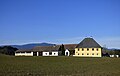
 Mairist, place-name sign and courtyard no.2 |
|||
| Source: STAT : index of places ; BEV : GEONAM ; KAGIS | |||

Mairist is a village in the municipality of Sankt Veit an der Glan in the Sankt Veit an der Glan district in Carinthia . The village has 22 inhabitants (as of January 1, 2020). It lies on the territory of the cadastral municipality of Sankt Donat .
location

The village is located in the south of the district of Sankt Veit an der Glan, southeast of the district capital Sankt Veit an der Glan. A few courtyards north of the Magdalensberg near the Krappfeld Straße (state road L83), between St. Donat and Hochosterwitz, form the core area of the village . In addition, a few houses belong to the village of Mairist, which are further north in the valley of the Ziegelbach and can only be reached today from the villages of Untermühlbach or Podeblach ; this small settlement bears the name Strolz .
history
Lying in the tax municipality of Sankt Donat, the place belonged to the tax district Osterwitz in the first half of the 19th century . When the local parishes were formed in the course of the reforms after the revolution of 1848/49, Mairist came to the parish of St. Georgen am Längsee , and in 1895 to the then newly founded parish of St. Donat . In 1958 Mairist came to the community of Sankt Veit an der Glan.
Population development
The following population figures were counted for the village:
- 1869: 12 houses, 91 inhabitants
- 1880: 12 houses, 80 inhabitants
- 1890: 13 houses, 90 inhabitants; including 3 houses with 14 residents in the Strolz area
- 1900: 10 houses, 77 inhabitants
- 1910: 10 houses, 70 inhabitants
- 1923: 9 houses, 74 inhabitants
- 1934: 70 inhabitants
- 1961: 8 houses, 46 inhabitants
- 2001: 9 buildings (9 of them with main residence) with 8 apartments and 9 households; 30 residents and 1 secondary residence case
- 2011: 8 buildings, 23 residents
There are 2 workplaces in the village (as of 2011; 2001: 2) and 5 agricultural and forestry operations (as of 2001).
Mairist. House number 6.

Mairist Airfield
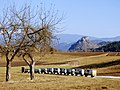
Beehives at Mairist

Former station house, Strolz


Individual evidence
- ↑ Statistics Austria: Population on January 1st, 2020 by locality (area status on January 1st, 2020) , ( CSV )
- ^ Wilhelm Rausch: Area and name changes of the municipalities of Austria. (= Research on the history of cities and markets in Austria , Volume 2). Linz, 1989. p. 246.
- ^ Central Statistical Commission: Local Repertory of the Duchy of Carinthia. Based on the census of December 31, 1869. Carl Gerold's Sohn, Vienna 1872. P. 70.
- ^ KK Statistische Central-Commission (Ed.): Complete list of localities of the kingdoms and countries represented in the Reichsrathe according to the results of the census of December 31, 1880. Alfred Hölder, Vienna 1882. P. 56.
- ↑ KK Statistische Central-Commission (Hrsg.): Local repertories of the kingdoms and countries represented in the Austrian Reichsrathe. Revised based on the results of the census of December 31, 1890. V. Carinthia. Alfred Hölder, Vienna 1894. p. 57.
- ↑ KK Central Statistical Commission (ed.): Community encyclopedia of the kingdoms and countries represented in the Reichsrat. Revised based on the results of the census of December 31, 1900. V. Carinthia. KK Hof- und Staatsdruckerei, Vienna 1905. p. 76.
- ^ Central Statistical Commission (ed.): Special locations repertory of the Austrian countries. Edited on the basis of the results of the census of December 31, 1910. V. Carinthia. Verlag der Staatsdruckerei, Vienna 1918. p. 41.
- ^ Federal Statistical Office (ed.): Directory of Austria. Edited on the basis of the results of the census of March 7, 1923. Österreichische Staatsdruckerei, Vienna 1930. Section Carinthia, p. 17.
- ↑ Handwritten addendum to the 1923 local directory (Federal Statistical Office (Hrsg.): Local directory of Austria. Edited on the basis of the results of the census of March 7, 1923. Österreichische Staatsdruckerei, Vienna 1930.) with the signature II 28238 of the Klagenfurt University Library. Section Carinthia, p. 17.
- ^ Austrian Central Statistical Office: Directory of Austria. Edited on the basis of the results of the census of March 21, 1961. Österreichische Staatsdruckerei, 1965. p. 257.
- ↑ a b c Statistics Austria (Ed.): Local directory 2001 Carinthia. Vienna 2004. p. 121.
- ^ A b Office of the Carinthian regional government, regional statistical office: Carinthian local directory. Territorial status January 1, 2014. Klagenfurt, 2014.

Cadastral communities: Galling | Hörzendorf | Niederdorf | Projecting | St. Donat | St. Veit an der Glan | Tanzenberg
Locations: Affelsdorf | Aich | Altglandorf | Arndorf | Baardorf | Baiersdorf | Leg rats | Blintendorf | Dellach | Draschelbach | Eberdorf | Galling | Gersdorf | Wood | Hörzendorf | Karlsberg | Karnberg | Laasdorf | Lebmach | Mairist | Milbersdorf | Muraunberg | Niederdorf | Plowing | Pörtschach am Berg | Preilitz | Projecting | Bike path | Raggasaal | Ritzendorf | St. Andrä | St. Donat | St. Veit an der Glan | Streimberg | Tanzenberg | Ulrichsberg | Unterbergen | Untermühlbach | Unterwuhr | Wainz | Between mountains
Former localities: Glandorf | Höfern | Neuglandorf | Prikalitz
(Former) parts of the village: Stadlhof | Strolz
Former suburbs: Friesacher Vorstadt | Klagenfurt suburb | Villach suburb | Völkermarkter Vorstadt | Weitensfeld suburb
Counting districts and districts: 00 Old town: 000 St. Veit an der Glan old town | 01 Inner city area: 010 Weitensfelder Vorstadt | 011 Friesacher Vorstadt | 012 Klagenfurt suburb | 013 St. Veit-Marktwiese | 014 St. Veit-Villacher-Vorstadt | 02 Outer city area: 020 St. Veit-Glanbogen | 021 Sankt Veit-Süd | 022 Muraunberg | 03 St. Donat: 030 St. Donat | 04 Hörzendorf: 040 Hörzendorf
Former communities: Hörzendorf community | Saint Donat parish