
St. Donat
|
St. Donat ( village ) locality |
|||
|---|---|---|---|
|
|||
| Basic data | |||
| Pole. District , state | Sankt Veit an der Glan (SV), Carinthia | ||
| Judicial district | Sankt Veit an der Glan | ||
| Pole. local community | Sankt Veit an der Glan ( KG St. Donat ) | ||
| Coordinates | 46 ° 44 '11 " N , 14 ° 23' 35" E | ||
| Residents of the village | 393 (January 1, 2020) | ||
| Building status | 95 (January 1, 2011 ) | ||
| Statistical identification | |||
| Locality code | 01661 | ||
| Counting district / district | St. Donat (20 527 030) | ||
 Saint Donat |
|||
| Source: STAT : index of places ; BEV : GEONAM ; KAGIS | |||

St. Donat is a village in the municipality of Sankt Veit an der Glan in the Austrian state of Carinthia with 393 inhabitants (as of January 1, 2020). Until the incorporation in 1958, the village was the capital of the municipality of Sankt Donat .
Geographical location
The village is in the area of the cadastral municipality of Sankt Donat , on the northern edge of the Zollfeld , four kilometers south of the town of St. Veit , on Zollfeld Straße L71. In the village, the Krappfeld Straße L83 branches off to Launsdorf and Hochosterwitz Castle .
Origin of the place name

The place is named after the patron saint of the parish church , Saint Donat (Latin: Sanctus Donatus). He can also be found in the parish church as the central high altar figure in the form of the Roman soldier Donatus , who was later canonized and clearly holds the lightning bolt in his right hand as a distinguishing mark.
history
In antiquity there was a Roman vicus with a temple area in the area of St. Donat and St. Michael am Zollfeld .
Lying in the tax municipality of Sankt Donat, the place belonged to the tax district Osterwitz in the first half of the 19th century . When the local congregations were formed in the course of the reforms after the revolution of 1848/49, St. Donat came to the community of St. Georgen am Längsee , and in 1895 to the then newly founded community of Sankt Donat . In 1958 the place came to the municipality of Sankt Veit an der Glan. In December 1959, the St. Donat gendarmerie was closed.
Population development
The following population figures were counted for the village:
- 1869: 21 houses, 154 inhabitants
- 1880: 23 houses, 153 inhabitants
- 1890: 19 houses, 147 inhabitants
- 1900: 19 houses, 142 inhabitants
- 1910: 20 houses, 119 inhabitants
- 1923: 21 houses, 137 inhabitants
- 1934: 145 inhabitants
- 1961: 28 houses, 190 inhabitants
- 2001: 73 buildings (73 of them with main residence) with 102 apartments and 96 households; 263 residents and 6 cases of secondary residence
- 2011: 95 buildings, 306 inhabitants
There are 17 workplaces in the village (as of 2011; 2001: 7) and 6 agricultural and forestry operations (as of 2001).
Buildings

- Parish Church of St. Donat : The place is known for its church, originally built in the Romanesque style, with pre-Celtic, Celtic and Roman relief stones with depictions of people and sculptures in the outer walls. The headless larger than life statue also walled in here, the "giantess of St. Donat", is a male figure from a Roman tomb. The head, which used to be walled in as a replacement for the lost original and is now walled in elsewhere, comes from the Middle Ages.
- The Schletterhof is a two-story mansion that was built in the 17th century over an older core.
- FunderMax Plant 3 by Coop Himmelblau , 1989, is an example of innovative industrial architecture. The system consists of two components - an energy center and a production hall. The energy center has a floor plan of 14 × 31 m and a height of 8 m with three chimneys, each 25 m high. The production hall measures 42 × 175 m with a height of 10.50 m. These two parts are connected by a media bridge (46 m long / 2.50 m wide). The hall has four small canopies and a large awning roof. The energy center also has a cascade (13 m high) and the three above-mentioned chimneys, which are called "dancing chimneys". Another spatial encroachment is the "exploding corner" in which the presentation and reception room is located. Construction: Hall: steel. Walls: curtain-type reinforced concrete prefabricated parts, above flush sheet metal panels. Exposure through sheds on the north long side.
society
- St. Donat Volunteer Fire Brigade
In March 1924 the founding meeting of the St. Donat Volunteer Fire Brigade took place. Just four years later, the community council decided to build a community hall next to the church. An extension was used by the volunteer fire brigade as a depot. In August 1928 the building was handed over to its destination. In 1949 a decisive step in the direction of mobility was taken with the purchase of a motor vehicle that was converted for use. In 1974 the volunteer fire brigade received a Unimog vehicle. On the night of January 10th to 11th, 1961, an arsonist set three farm buildings on fire. This mission was probably the greatest challenge in the history of the St. Donat volunteer fire brigade. The person who caused the fire was caught that same night. In 1990 the Florianijünger had to pass another test. After an explosion in the Funderwerk in Glandorf (Carinthia), a poison gas alarm was announced over the radio. The fire brigade was on duty for hours with heavy breathing protection. In April 1995 the Funder drying plant caught fire. The St. Donat volunteer fire brigade was on duty for 18 hours. With the expansion of the industrial and commercial park, the St. Donat volunteer fire brigade got more and more deployments and gained in importance. The S37 also represents a further operational challenge. In 2017 Untermühlbach was hit by a flood of the Ziegelbach after a storm , and the St. Donat fire brigade was on duty for 2 days.
- St. Donat singing group
- St. Donat theater group, theater performances and readings
- Traditional costume chapel St. Donat / Glandorf (Carinthia)
Special

The place is on the approach of the Sörger participants to the Vierberglauf on the day before the three-nail Friday (second Friday after Easter). A stone table in the form of a rock slab is located on a ledge near the ascent to Magdalensberg . From St. Donat, the marked path No. 814, with a time of two hours, leads to the Magdalensberg.
Personalities
- Stefan Knafl (1927–2005), politician
- Anton Schmid (1915–1996), poet, composer and innovator of the Carinthian song, teacher and choir director

St. Donat at the junction to Hochosterwitz

St. Donat with church and war memorial
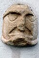
Head sculpture, called "frog mouth"

Schletterhof


Web links
Individual evidence
- ↑ Statistics Austria: Population on January 1st, 2020 by locality (area status on January 1st, 2020) , ( CSV )
- ^ Wilhelm Rausch: Area and name changes of the municipalities of Austria. (= Research on the history of cities and markets in Austria , Volume 2). Linz, 1989. p. 246.
- ↑ Simone Julia Zluga: The Carinthian Gendarmerie 1945-1960 - Organizational changes and developments. Diploma thesis, Graz 2014. p. 66.
- ^ Central Statistical Commission: Local Repertory of the Duchy of Carinthia. Based on the census of December 31, 1869. Carl Gerold's Sohn, Vienna 1872. P. 70.
- ^ KK Statistische Central-Commission (Ed.): Complete list of localities of the kingdoms and countries represented in the Reichsrathe according to the results of the census of December 31, 1880. Alfred Hölder, Vienna 1882. P. 56.
- ↑ KK Statistische Central-Commission (Hrsg.): Local repertories of the kingdoms and countries represented in the Austrian Reichsrathe. Revised based on the results of the census of December 31, 1890. V. Carinthia. Alfred Hölder, Vienna 1894. p. 57.
- ↑ KK Central Statistical Commission (ed.): Community encyclopedia of the kingdoms and countries represented in the Reichsrat. Revised based on the results of the census of December 31, 1900. V. Carinthia. KK Hof- und Staatsdruckerei, Vienna 1905. p. 76.
- ^ Central Statistical Commission (ed.): Special locations repertory of the Austrian countries. Edited on the basis of the results of the census of December 31, 1910. V. Carinthia. Verlag der Staatsdruckerei, Vienna 1918. p. 41.
- ^ Federal Statistical Office (ed.): Directory of Austria. Edited on the basis of the results of the census of March 7, 1923. Österreichische Staatsdruckerei, Vienna 1930. Section Carinthia, p. 17.
- ↑ Handwritten addendum to the 1923 local directory (Federal Statistical Office (Hrsg.): Local directory of Austria. Edited on the basis of the results of the census of March 7, 1923. Österreichische Staatsdruckerei, Vienna 1930.) with the signature II 28238 of the Klagenfurt University Library. Section Carinthia, p. 17.
- ^ Austrian Central Statistical Office: Directory of Austria. Edited on the basis of the results of the census of March 21, 1961. Österreichische Staatsdruckerei, 1965. p. 257.
- ↑ a b c Statistics Austria (Ed.): Local directory 2001 Carinthia. Vienna 2004. p. 121.
- ^ A b Office of the Carinthian regional government, regional statistical office: Carinthian local directory. Territorial status January 1, 2014. Klagenfurt, 2014.

Cadastral communities: Galling | Hörzendorf | Niederdorf | Projecting | St. Donat | St. Veit an der Glan | Tanzenberg
Locations: Affelsdorf | Aich | Altglandorf | Arndorf | Baardorf | Baiersdorf | Leg rats | Blintendorf | Dellach | Draschelbach | Eberdorf | Galling | Gersdorf | Wood | Hörzendorf | Karlsberg | Karnberg | Laasdorf | Lebmach | Mairist | Milbersdorf | Muraunberg | Niederdorf | Plowing | Pörtschach am Berg | Preilitz | Projecting | Bike path | Raggasaal | Ritzendorf | St. Andrä | St. Donat | St. Veit an der Glan | Streimberg | Tanzenberg | Ulrichsberg | Unterbergen | Untermühlbach | Unterwuhr | Wainz | Between mountains
Former localities: Glandorf | Höfern | Neuglandorf | Prikalitz
(Former) parts of the village: Stadlhof | Strolz
Former suburbs: Friesacher Vorstadt | Klagenfurt suburb | Villach suburb | Völkermarkter Vorstadt | Weitensfeld suburb
Counting districts and districts: 00 Old town: 000 St. Veit an der Glan old town | 01 Inner city area: 010 Weitensfelder Vorstadt | 011 Friesacher Vorstadt | 012 Klagenfurt suburb | 013 St. Veit-Marktwiese | 014 St. Veit-Villacher-Vorstadt | 02 Outer city area: 020 St. Veit-Glanbogen | 021 Sankt Veit-Süd | 022 Muraunberg | 03 St. Donat: 030 St. Donat | 04 Hörzendorf: 040 Hörzendorf
Former communities: Hörzendorf community | Saint Donat parish