
St. Michael am Zollfeld
|
St. Michael am Zollfeld ( village ) locality cadastral community St. Michael am Zollfeld |
|||
|---|---|---|---|
|
|||
| Basic data | |||
| Pole. District , state | Klagenfurt-Land (KL), Carinthia | ||
| Judicial district | Klagenfurt | ||
| Pole. local community | Maria Hall | ||
| Coordinates | 46 ° 43 '4 " N , 14 ° 22' 44" E | ||
| height | 488 m above sea level A. | ||
| Residents of the village | 193 (January 1, 2020) | ||
| Building status | 73 (2001) | ||
| Area d. KG | 3.35 km² | ||
| Statistical identification | |||
| Locality code | 00891 | ||
| Cadastral parish number | 72169 | ||
| Counting district / district | St. Michael am Zollf.-Umg. (20418 003) | ||
 St. Michael am Zollfeld with the Catholic parish church St. Michael |
|||
| Source: STAT : index of places ; BEV : GEONAM ; KAGIS | |||

St. Michael am Zollfeld is a village and cadastral municipality in the municipality of Maria Saal am Carinthian Zollfeld . The place is on the eastern edge of the Zollfeld, east of Friesacher Straße (B 317). The place consists of 73 buildings and has a resident population of 214 people (2001). The cadastral community is 335.24 hectares and includes the town of St. Michael, Rotheis, Techmannsdorf and Willersdorf. St. Michael was first mentioned in 1142 as Neuenhof in Holzgraz .
Parish church


The parish church consecrated to the Archangel Michael stands on a hill on the north eastern edge of the village. It was first mentioned in a document in 1162.
Building
The Gothic building and has a defensive upper floor and loopholes. After a fire in 1739 the church was partly rebuilt in baroque style. The polygonal choir dates from the 15th century. On the south side, the church was widened by adding a baroque vestibule in front of the Gothic arched portal and a sacristy. The Gothic tower is on the southwest corner. He wears a pointed helmet and has ogival sound windows and chamfered staircase windows. In the masonry of the church there are numerous spoils from Roman funerary monuments from nearby Virunum .
The interior of the nave has a flat roof and is decorated with acanthus stucco by Kilian Pittner from 1710, depicting mussels, putti heads and fruit containers. The ceiling painting shows the coronation of Mary . A cloud at Mary's feet reveals a face as a symbol of overcoming original sin. The apse has a 5/8 end and a star-shaped rib vault.

Gothic keel arch portal

Roman relief medallion (portrait tombstone of a Roman couple)
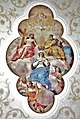
Ceiling painting with the coronation of Mary


Facility

The high altar dates from around 1780/90. The altar panel shows the fall from hell . Figures of the apostles Peter on the left and Paul on the right stand on the side pedestals . An eye of providence in the wreath of clouds and rays forms the top.
Two side altars date from the 3rd quarter of the 17th century, the altar leaves show Maria Immaculata and St. Antonius Eremita. On the south wall of the nave are console statues of St. Andrew with St. Andrew's cross as an attribute , St. James the Elder with a pilgrim's staff and the Archangel Michael with a flaming sword and scales standing on a dragon. An octagonal baptismal font belongs to the further facility .

St. Andrew

St. James the Elder Ä.

archangel Michael

Baptismal font


Roman vicus
In Roman times there was a vicus , a settlement of around three hectares , in the area of St. Michael and the neighboring St. Donat . It is located at the intersection of the Norican main road, which leads north from Virunum, and a west-east side road that led from the Liebenfels area to the city on the Magdalensberg . The beginnings go back to the early imperial era. The finds range from the second half of the first to the second half of the fourth century AD. It was located around 2.7 km north of the forum of Virunum , the capital of the province of Noricum . (new findings under discussion)
A Roman temple district was built over part of the vicus at the time of Emperor Hadrian . It is interpreted as consecrated to Hercules and the imperial cult and resembles urban Roman and provincial imperial cult fora. The floor plan is a slightly warped parallelogram . There are taberns on all four sides with a portico in front of them on the inside and which were probably accessible from the inner courtyard. In the south, a hall, also reconstructed as a porticus, has a total length of 38 meters. Due to the wall thickness, a two-storey development of the south wing can be assumed. In the middle of the south side was the entrance that led from the lower street into the temple precinct. In the middle of the west and east sides were two exedra with a radius of 6.6 meters. Inside the temple precinct was a podium temple . Fragments of life-size marble statues were found in the temple district, a votive altar to Hercules Augustus, and a bronze statuette of Hercules bibax in the wider area as early as 1984/86 .
literature
- Dehio - The art monuments of Austria: Carinthia . Verlag Anton Schroll, Vienna 1981, p. 576. ISBN 3-7031-0522-4 (parish church)
- Heimo Dolenz : The excavations in the temple district near St. Michael in Zollfeld in 2004. In: Rudolfinum. Yearbook of the Landesmuseum Kärnten 2004. Klagenfurt 2005, ISBN 3-900575-31-2 , pp. 241-251 ( PDF on ZOBODAT ; roman vicus).
- Heimo Dolenz: The excavations in the temple district near St. Michael in Zollfeld in 2005. In: Rudolfinum. Yearbook of the Landesmuseum Kärnten 2005. Klagenfurt 2007, ISBN 978-3-900575-36-6 , pp. 143–152 ( PDF on ZOBODAT ; roman vicus).
Web links
Individual evidence
- ↑ a b Statistics Austria: Ortverzeichnis Kärnten 2001 , Vienna 2004. ISBN 3-902452-41-2