
Project
|
Projern ( village ) locality |
|||
|---|---|---|---|
|
|||
| Basic data | |||
| Pole. District , state | Sankt Veit an der Glan (SV), Carinthia | ||
| Judicial district | Sankt Veit an der Glan | ||
| Pole. local community | Sankt Veit an der Glan ( KG Projern ) | ||
| Coordinates | 46 ° 43 '21 " N , 14 ° 19' 7" E | ||
| height | 583 m above sea level A. | ||
| Residents of the village | 47 (January 1, 2020) | ||
| Building status | 22 (January 1, 2011 ) | ||
| Statistical identification | |||
| Locality code | 01377 | ||
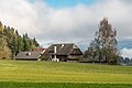
 Projecting, view from the south |
|||
| Source: STAT : index of places ; BEV : GEONAM ; KAGIS | |||

Projern is a village in the municipality of St. Veit an der Glan in the Sankt Veit an der Glan district in Carinthia . The village has 47 inhabitants (as of January 1, 2020). It lies in the area of the cadastral community of Projern .
location
The village is located in the Glantaler Bergland in the south of the Sankt Veit district, northeast of Ulrichsberg and southwest of Hörzendorf . The village also includes the Raner farms (house no.20 , north-east outside the village) and Thurmweber (house no.14 , north-west outside the village; so named because of the nearby ruins of Karlsberg Castle ) and the hamlet Schmied (house no.10 , 11, 12, 17) southwest outside the village.
history
The place was mentioned at the beginning of the 11th century. The parish church of St. Ruprecht is mentioned in 1078.
Located in the tax municipality of Projern, the place belonged to the tax district of Karlsberg in the first half of the 19th century . When the local congregations were formed in the course of the reforms after the revolution of 1848/49, Projern came to the Hörzendorf community (which was initially run under the name of Karlsberg community ), and in 1972 to the Sankt Veit an der Glan community.
Population development
The following population figures were counted for the village:
- 1869: 18 houses, 120 inhabitants
- 1880: 17 houses, 121 inhabitants
- 1890: 17 houses, 125 inhabitants
- 1900: 18 houses, 127 inhabitants
- 1910: 17 houses, 91 inhabitants
- 1923: 14 houses, 93 inhabitants
- 1934: 89 inhabitants
- 1961: 13 houses, 76 inhabitants
- 2001: 22 buildings (22 of them with main residence) with 23 apartments and 21 households; 56 residents and 3 cases of secondary residence
- 2011: 22 buildings, 58 inhabitants
Infrastructure
There are 6 workplaces in the village (as of 2011; 2001: 1) and 10 agricultural and forestry operations (as of 2001).
In 1810 there was already a school set up by the pastor in Projern. In 1831 the school was moved into a specially built school and sacristan's house.

Rectory, former medieval fortification
Farmhouse blacksmith (No. 12)

Projern village sign, then part of the Hörzendorf municipality

Römerstein at the parish church


Individual evidence
- ↑ Statistics Austria: Population on January 1st, 2020 by locality (area status on January 1st, 2020) , ( CSV )
- ^ Wilhelm Rausch: Area and name changes of the municipalities of Austria. (= Research on the history of cities and markets in Austria , Volume 2). Linz, 1989. p. 245.
- ^ Central Statistical Commission: Local Repertory of the Duchy of Carinthia. Based on the census of December 31, 1869. Carl Gerold's Sohn, Vienna 1872. P. 73.
- ↑ KK Statistische Central-Commission (Ed.): Complete list of localities of the kingdoms and countries represented in the Reichsrathe according to the results of the census of December 31, 1880. Alfred Hölder, Vienna 1882. S. 58.
- ↑ KK Statistische Central-Commission (Hrsg.): Local repertories of the kingdoms and countries represented in the Austrian Reichsrathe. Revised based on the results of the census of December 31, 1890. V. Carinthia. Alfred Hölder, Vienna 1894. p. 58.
- ↑ KK Central Statistical Commission (ed.): Community encyclopedia of the kingdoms and countries represented in the Reichsrat. Revised based on the results of the census of December 31, 1900. V. Carinthia. KK Hof- und Staatsdruckerei, Vienna 1905. p. 78.
- ^ Central Statistical Commission (ed.): Special locations repertory of the Austrian countries. Edited on the basis of the results of the census of December 31, 1910. V. Carinthia. Verlag der Staatsdruckerei, Vienna 1918. p. 39.
- ^ Federal Statistical Office (ed.): Directory of Austria. Edited on the basis of the results of the census of March 7, 1923. Österreichische Staatsdruckerei, Vienna 1930. Section Carinthia, p. 16.
- ↑ Handwritten addendum to the 1923 local directory (Federal Statistical Office (Hrsg.): Local directory of Austria. Edited on the basis of the results of the census of March 7, 1923. Österreichische Staatsdruckerei, Vienna 1930.) with the signature II 28238 of the Klagenfurt University Library. Section Carinthia, p. 16.
- ^ Austrian Central Statistical Office: Directory of Austria. Edited on the basis of the results of the census of March 21, 1961. Österreichische Staatsdruckerei, 1965. p. 256.
- ↑ a b c Statistics Austria (Ed.): Local directory 2001 Carinthia. Vienna 2004. 121.
- ^ A b Office of the Carinthian regional government, regional statistical office: Carinthian local directory. Territorial status January 1, 2014. Klagenfurt, 2014.

Cadastral communities: Galling | Hörzendorf | Niederdorf | Projecting | St. Donat | St. Veit an der Glan | Tanzenberg
Locations: Affelsdorf | Aich | Altglandorf | Arndorf | Baardorf | Baiersdorf | Leg rats | Blintendorf | Dellach | Draschelbach | Eberdorf | Galling | Gersdorf | Wood | Hörzendorf | Karlsberg | Karnberg | Laasdorf | Lebmach | Mairist | Milbersdorf | Muraunberg | Niederdorf | Plowing | Pörtschach am Berg | Preilitz | Projecting | Bike path | Raggasaal | Ritzendorf | St. Andrä | St. Donat | St. Veit an der Glan | Streimberg | Tanzenberg | Ulrichsberg | Unterbergen | Untermühlbach | Unterwuhr | Wainz | Between mountains
Former localities: Glandorf | Höfern | Neuglandorf | Prikalitz
(Former) parts of the village: Stadlhof | Strolz
Former suburbs: Friesacher Vorstadt | Klagenfurt suburb | Villach suburb | Völkermarkter Vorstadt | Weitensfeld suburb
Counting districts and districts: 00 Old town: 000 St. Veit an der Glan old town | 01 Inner city area: 010 Weitensfelder Vorstadt | 011 Friesacher Vorstadt | 012 Klagenfurt suburb | 013 St. Veit-Marktwiese | 014 St. Veit-Villacher-Vorstadt | 02 Outer city area: 020 St. Veit-Glanbogen | 021 Sankt Veit-Süd | 022 Muraunberg | 03 St. Donat: 030 St. Donat | 04 Hörzendorf: 040 Hörzendorf
Former communities: Hörzendorf community | Saint Donat parish