Schluisee
| The former Schluifelder See | ||
|---|---|---|

|
||
| Geographical location | Wörthsee municipality , Starnberg district , Upper Bavaria , Bavaria , Germany | |
| Tributaries | Bulachbach | |
| Drain | Bulachbach → Wörthsee | |
| Places on the shore | Waldbrunn, Schluifeld (districts of the municipality of Wörthsee) | |
| Data | ||
| Coordinates | 48 ° 4 '50 " N , 11 ° 12' 37" E | |
|
|
||
| Altitude above sea level | 574 m | |
The Schluifelder See , also Schluisee , was a dead ice and moor lake in the north of the municipality of Wörthsee in Germany. The Schluifelder Moos has been located in its place since drainage efforts at the end of the 19th century .
The lake was the largest of the northern Toteisbecken, würmeiszeitlichen Ammersee glacier .
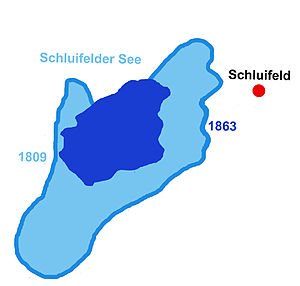
Around 1400 the lake is said to have been around 128 days (0.43 km²) in size. Its area then decreased over time, probably due to siltation. The map of Philipp Apian shows the lake in 1566 only slightly larger than the nearby Weßlinger See (0.17 km²). A map at the beginning of the 19th century shows the Schluifelder See, however, somewhat larger than the Weßlinger See. In 1815 its area is said to have been 65 days (0.22 km²).
In order to gain arable land, the outflow of the lake was widened and deepened in 1815. As a result, it shrank to 36 days of work (0.12 km²), but the land that was gained was sterile. A moor belt enclosed it almost completely, only on the eastern side of the lake there was still a lake access with solid ground. The lake had become so shallow that you had to go far in for the water to reach your knees. Nevertheless, it was still considered rich in fish.
In the 1880s, the lake's outflow was increased again in order to finally drain the lake. After the lake level had sunk by another two meters, the drainage was officially concluded in 1889. As a result, however, the drainage failed. The lake had become a bog: "Peat bogs are spreading over the former lake area, horsetail, rushes with reeds, water moss and bristle grass form a floating blanket over the barely visible swamp water."
In the 20th century, thought was given to draining the area again. This time to create settlement space. In the end, however, the insight prevailed that the Schluifelder Moos is a natural area worth protecting. Since 1954 it is under conservation , in 1986 it became a protected area declared. The moor is not only a retreat for rare plants and the habitat of over seventy species of birds. It belongs to the type of moor, which is rare in Bavaria, in which the surface of the moor floats on a water bubble (swimming lawn). The moor is at an altitude of 575 m above sea level. d. M. and has an area of 0.56 km².
literature
- Werner Bülow: Wörthsee and its surroundings. Forays into local history. Oreos Verlag, Waakirchen 2004, ISBN 978-3-923657-79-7
- Gustl Empfenzeder: History of the Ammersee home. 2nd Edition. Self-published, Herrsching 1978, ISBN 978-8-455575-71-7
- Hans Porkert: At the Weßlinger See. A home book in words and pictures by Hans Porkert. Municipality of Weßling (ed.), Weßling 1986
- Heimatverein Wörthsee (ed.): 1200 years Etterschlag - 800 years Schluifeld. 2006
Web links
Individual evidence
- ↑ Bavarian State Office for Environmental Protection: Official Journal of the European Communities No. L 107/4, reference number: DE7933301. 2000, p. 12 online (PDF; 55 kB).
- ↑ Bülow p. 106 f., Heimatverein p. 510
- ↑ See Heimatverein p. 510
- ↑ Year: Heimatverein p. 510, Bülow p. 110
- ↑ Bülow p. 110 with reference to Friedrich Töpfer, the archivist of Count von Toerring in the 19th century. In 1909, Josef Reindl gives a lake area of 80 days' work (0.27 km²) for around 1880. (Josef Reindl: The small moraine lakes between Ammer and Würmsee. 1909. Quoted from: Porkert p. 512)
- ↑ Porkert p. 512, Bülow p. 110
- ↑ There are different statements about the year in which the drainage took place. 1897 (Empfenzeder p. 217), 1888 according to the Weßlinger Kaplan Josef Völk (Porkert p. 512), officially June 1889 (Bülow p. 110 f.)
- ^ Josef Reindl: The small moraine lakes between Ammer and Würmsee. 1909. Quoted from: Porkert p. 512
- ↑ Heimatverein p. 510
- ↑ Heimatverein p. 510 f.
- ↑ Heimatverein p. 511 - Bavarian State Office for Environmental Protection: Official Journal of the European Communities No. L 107/4, reference number: DE7933301. (PDF; 55 kB) 2000, p. 12 - Press releases from the government of Upper Bavaria. No. 528 of December 8, 2006

