
Schneiderberg (Hanover)

Schneiderberg is the name of a street in Hanover that connects Nienburger Strasse with Halthoffstrasse in the Nordstadt district .
History and description

The Schneiderberg elevation was part of an ancient, elongated dune that stretched from the Klagesmarkt to the Berggarten and beyond to the former rabbit mountain northwest of Herrenhausen . The sand ridge has been largely eroded over time for building purposes. Especially in the first years of the Electorate of Braunschweig-Lüneburg at the end of the 17th century, the naturally created Schneiderberg did not correspond to the magnificent catchment area desired by the state rulers for the baroque Herrenhausen Palace, which is currently under construction . So the country road leading from Hanover in the direction of Nienburg to the Great Garden , the Nienburger Straße, was initially just an unpaved , "somewhat broad sandy path" lined with poplars and willows . Therefore, the road leading to the castle was regulated between 1692 and 1693 at a total cost of 1243 thalers and the sand ridge on the Schneiderberg was largely removed.
At the time of the Kingdom of Hanover , the Schneiderberg was named as an elevated point in the area around 1830, presumably after the old field name .
Towards the end of the Weimar Republic , various institute buildings were built between 1928 and 1931 on the corner of Nienburger Strasse for the then Technical University , including the Franzius Institute for Hydraulic Engineering.
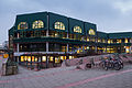
Main canteen of the university on Schneiderberg at the corner of Callinstraße
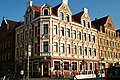
Kaiser restaurant in the corner building on Schaufelder Strasse

Advertising board for the Heinrich Bachmann building and furniture joinery founded in 1891


Web links
Individual evidence
- ↑ a b c Helmut Zimmermann : Schneiderberg , in ders .: The street names of the state capital Hanover . Verlag Hahnsche Buchhandlung, Hannover 1992, ISBN 3-7752-6120-6 , p. 221
- ↑ a b Yearbook of the Technical University of Hanover , (1952), p. 66; limited preview in Google Book search
- ↑ a b c Karl H. Meyer : Royal Gardens. Three hundred years Herrenhausen , Hanover: Fackelträger-Verlag Schmidt-Küster, 1966, p. 86; limited preview in Google Book search
- ↑ Helmut Knocke , Hugo Thielen : Nienburger Strasse 1–5 , in Dirk Böttcher , Klaus Mlynek (ed.): Hanover. Kunst- und Kultur-Lexikon (HKuKL), new edition, 4th, updated and expanded edition, zu Klampen, Springe 2007, ISBN 978-3-934920-53-8 , p. 173
Coordinates: 52 ° 23 ' N , 9 ° 43' E