
Schoppendorf
|
Schoppendorf
City of Bad Berka
Coordinates: 50 ° 55 ′ 42 ″ N , 11 ° 16 ′ 6 ″ E
|
|
|---|---|
| Height : | 357 m above sea level NN |
| Residents : | 114 (2011) |
| Incorporation : | March 1, 1974 |
| Incorporated into: | Bergern |
| Postal code : | 99438 |
| Area code : | 036458 |
 Location of Schoppendorf in Bad Berka
|
|
Schoppendorf is a district of the city of Bad Berka in the Weimarer Land district in Thuringia .
geography
Schoppendorf is north of Bad Berka and north behind Bergern at the foot of the Hexenberg and can be reached by public transport via the federal highway 85 and the local road to the town. The place lies in a hollow of the plateau between Legefeld and Troistedt .
history
The first written record was registered on March 26, 1241. The settlement goes back to Franconian immigrants. The cultivation of woad played a major role for the local farmers. That is why a Waidstein monument on the Anger is a reminder of this period. This place was also destroyed in the Thirty Years War . The reconstruction took place immediately afterwards. The village once belonged to the manorial property of the Counts of Orlamünde . Small and medium-sized farmers cultivated the areas in the district. The town's agriculture was forcibly collectivized after the Second World War during the GDR era and found new directions of development after the fall of the Wall . In 2011, 114 people lived in the village. The district mayor is currently Siegfried Fürst.
→ See also St. Martin (Schoppendorf)
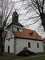
Church in Schoppendorf

War memorial in front of the church in Schoppendorf

Waidmühlstein monument in Schoppendorf


Individual evidence
- ↑ a b Schoppendorf on the Bad Berka website. Retrieved September 25, 2011.
- ^ Wolfgang Kahl : First mention of Thuringian towns and villages. A manual. 5th, improved and considerably enlarged edition. Rockstuhl, Bad Langensalza 2010, ISBN 978-3-86777-202-0 , p. 290.
