Schwarzensee (Berchtesgadener Land)
| Schwarzensee | ||
|---|---|---|

|
||
| Geographical location | Berchtesgaden Alps | |
| Drain | underground | |
| Data | ||
| Coordinates | 47 ° 30 '22.3 " N , 12 ° 58' 6.2" E | |
|
|
||
| Altitude above sea level | 1568 m above sea level NHN | |
| surface | 0.55 ha | |
| length | 125 m | |
| width | 73 m | |
| scope | 340 m | |
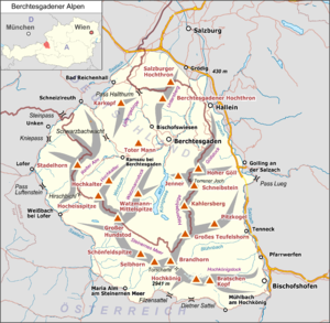
The Schwarzensee (also Schwarzsee ) is a small karst lake in the Berchtesgaden Alps . It is located in the Bavarian municipality of Schönau am Koenigssee above the Koenigsee at an altitude of 1568 m, 490 m southwest of the dilapidated Hals Alm and 1460 m southwest of the Obersee . Its area is 5500 square meters and the circumference is around 340 meters. It is accessible via a junction from the Sagerecksteig .
The Schwarzensee drains underground to the Königssee, whereby the water takes about 20 hours.
Other karst lakes nearby - and therefore not far from the Salzburg border - are Funtensee and Grünsee .
Individual evidence
- ↑ Karst hydrological markings in the Berchtesgaden National Park. (PDF; 9.6 MB) pp. 25–26 , accessed on April 22, 2017 (Section 2.4.3 Results ).
Web links
Commons : Schwarzensee - Collection of images, videos and audio files
- High mountain lakes, berchtesgadener-tal.de
