
Black pond

Schwarzes Teich is a pond in the Kötzschenbroda Oberort district of the Saxon city of Radebeul . It is located in the headwaters of today's Radebeul-West Forest Park , on the north side of the actual Steinrücken , the namesake of the middle Radebeul Steinrück vineyards . The gravel pit path runs just north of Schwarzes Teich. The pond is named after the merchant Georg Wilhelm Schwarz (1782–1842), the owner of the Friedstein vineyard below , who later also co-founded the nearby Bussard sparkling wine cellar . A public renaming to Lamsbach's pond in 1898 did not prevail and was brought back at the beginning of the 20th century.
To the east of Schwarzes Teich, several ponds were formerly created, including Gießmanns Teich , named after the owner of the nearby Friedensburg , just east of the water tower on the slope edge .
history


Around the middle of the 18th century, the electoral Oberlandweinmeister Roos had a water pipe laid from above the slope edge of the Steinrücken from the source area there to his Friedstein winery below ( Roos'sche Wasserleitung ) in order to supply it with service water, while drinking water continues from below where Winzerstraße, located fountain was brought.
Georg Schwarz or Schwarze, later owner of the winery, had the pond built in the first third of the 19th century , for which the colloquial name Schwarzes Teich became established in the period that followed . This pond served to ensure the service water supply of the winery via the Roos'sche water pipe and to keep the manor's fountain in operation. The Gießmann tunnel , which was driven through the mountain from 1876 to 1878 , was also supplied by Schwarzes Teich , which was supposed to supply the Badhotel with water.
From 1878, Altfriedstein belonged to Carl Lamsbach (1844–1919), who later became the first parish elder of the Niederlößnitz parish . He built a machine house and a reservoir on the hilltop so that the drinking water no longer had to be carried up from the well located lower on Winzerstraße. In addition, the property was still supplied with service water via the water pipe from Schwarzes Teich, which had already been laid by Roos and ended in the courtyard on the north side of the house. In order to honor Lamsbach for his support of the Beautification Association for the Loessnitz , the pond was renamed Lamsbach's pond in 1898 . The previous colloquial term later caught on again.
In 1910, the Niederlößnitz community bought the pond and the adjacent meadows and contributed them to the Waldpark Foundation for the Radebeul-West Forest Park . The pond was leased from them. During the warm season it was used to raise carp . In winter it was used to make ice for cooling purposes ( ice cellar ), and it also served as an ice rink .
During the GDR era, it formed the center of the Schwarzes Teich recreation area established in 1971 ; It was also used as a rearing water by the local anglers' association.
Today, Schwarzes Teich is part of the Radebeul-West forest park , which in turn is part of the Lößnitz conservation area. It flows over the northwest corner of the forest park, along the Leimgrunds (Kiesgrubenweg, Sonnenleite and Moritzburger Straße), and is discharged into a sewer approximately at the level of the Mohrenhaus , at the turning hammer of the Obere Bergstraße . This leads along the upper part of Oberen Bergstrasse, west of Kellereistrasse and along Käthe-Kollwitz-Strasse to Meißner Strasse . To the west of the Radebeul-Kötzschenbroda train station , the canal runs under the railroad tracks, then west of Bahnhofstrasse to the intersection with Anger Altkötzschenbroda . To the east of the sports home on the Festwiese, the drain emerges from a small barrage and flows openly into the Elbe .
Every year at the beginning of June, Radebeul choirs meet to sing in the forest park at Schwarzes Teich .
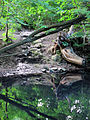
Inflow on the north side of Schwarzes Teich

Drain on the west side of Schwarzes Teich

Introduction into the piping at the turning hammer of the Obere Bergstrasse

Introduction into the piping on the Obere Bergstrasse, flood 2013


literature
- Frank Andert (Red.): Radebeul City Lexicon . Historical manual for the Loessnitz . Published by the Radebeul City Archives. 2nd, slightly changed edition. City archive, Radebeul 2006, ISBN 3-938460-05-9 .
Web links
- Manfred Richter: Waldpark Niederlößnitz / Kötzschenbroda, Schwarze's Teich. In: Niederlößnitz from yesteryear. Retrieved June 13, 2012 .
- City map of Niederlößnitz around 1924 (Schwarzes Teich is up in the middle of the forest park, on the left and upper edge of which is the Leimgrund), accessed on June 23, 2012.
Individual evidence
- ↑ Lössnitz and Moritzburger Teichlandschaft (= values of our homeland . Volume 22). 1st edition. Akademie Verlag, Berlin 1973, p. 175.
- ^ Adolf Schruth, Manfred Richter (arrangement): Chronik Niederlößnitz . Radebeul 1930 ( online version (pdf; 427 kB) - edited by Manfred Richter, 2010).
- ↑ Geoportal of the district of Meißen , accessed on June 27, 2012.
- ^ Forest park singing at Black Pond. Press release of the city of Radebeul from June 3, 2010.
Coordinates: 51 ° 7 ′ 12 ″ N , 13 ° 38 ′ 16 ″ E