Schwarzkogel (Rosaliengebirge)
| Schwarzkogel | ||
|---|---|---|
|
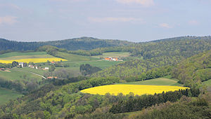
Schwarzkogel (left in the middle of the picture) and Rosaliengebirge from the south |
||
| height | 673 m above sea level A. | |
| location | Burgenland | |
| Mountains | Rosaliengebirge | |
| Dominance | 0.78 km → Greimkogel | |
| Coordinates | 47 ° 40 ′ 49 " N , 16 ° 20 ′ 32" E | |
|
|
||
The Schwarzkogel is 673 m above sea level. A. high mountain in the Rosaliengebirge in Burgenland .
The Schwarzkogel is located in the municipality of Mattersburg , only about 150 meters north of the border with Lower Austria . There begins on its flanks the Hocheckgraben with the Schwarzenbacher Rotte Hocheckgraben and to the east of it Eggenbuch . The neighboring mountain in the east is the 677 m high Greimkogel , in the north lies the Böse Reit valley .
From a geological perspective, the Schwarzkogel consists of mica schist overlaid with coarse gneiss . The Schwarzkogel is completely forested. The area is accessed with numerous forest and footpaths, none of which lead to the summit. A chapel can be found on the saddle of the Greimkogel.

