
Schweizerhaus (Weyher in the Palatinate)
| Schweizerhaus PWV hut |
||
|---|---|---|
 Swiss house |
||
| location | Haardt (Palatinate Forest) ; Weyher - Südliche Weinstrasse district , Rhineland-Palatinate | |
| Mountain range | Palatinate Forest | |
| Geographical location: | 49 ° 15 '55 " N , 8 ° 4' 25" E | |
| Altitude | 407 m | |
|
||
| owner | Palatinate Forest Association | |
| Construction type | Hut; Truss | |
| Usual opening times | August - October: Tue – Thu, Sat, Sun, 11 am–7pm. November - February: Wed, Sat, Sun, 11 a.m. - 5 p.m. | |
| Web link | PWV Weyher | |

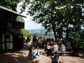
The Schweizerhaus is a refuge in the Palatinate Forest leased to landlords by the Weyher local group of the Palatinate Forest Association . It is located in the southern part of the Haardt on the southern slope of the Blättersberg ( 618 m ). The hut is located at an altitude of ( 407 m above sea level ). From the terrace of the hut there is an excellent view of the Rhine plain .
history
A previous building was built in 1880 by the district beautification association Edenkoben. The current half-timbered building was built between 1932–1933. The hut has not been managed since 2012 because extensive renovation work was pending. On November 14, 2015, the groundbreaking ceremony for a comprehensive renovation took place, which included an extension in the form of an extension for the kitchen and sanitary facilities. The topping-out ceremony for the new extensions was celebrated on June 11, 2016 . After these massive renovations, the Schweizerhaus was reopened on August 11, 2018 but had to be closed again due to technical problems. Since June 20, 2019, the Swiss house has reopened with a new tenant.
Access and walks
The hut can only be reached on foot. The shortest ascent from Weyher can be done in around 30 minutes. The hut can be reached from Rhodt via the Rietaniahütte in around an hour. Another access can be made from Buschmühle in Modenbachtal in about 30 minutes.
Hiking destinations near the hut are the Ludwigsturm ( 605 m ) and from there the Blättersberg and the ruins of the Rietburg . After crossing the Modenbach valley, you can reach the St. Anna chapel on the Annaberg, known as a pilgrimage chapel and pilgrimage church . A few hundred meters down the valley from the hut there is a Marian grotto. The neighboring huts of the Palatinate Forest Association are the St. Anna Hut , the Trifelsblick Hut and the Edenkobener Hut .
Picture gallery

Hut before renovation
View of the Rhine plain

Mariengrotte near Weyher

Ludwigsturm

Blättersberg


literature
- AK Doerr: Palatinate Hüttenbuch - The guide to 99 rest houses and hikers' homes . Pfälzische Verlagsanstalt Ludwigshafen GmbH, 4th edition June 2018, ISBN 978-3-87629-341-7 , p. 174.
- Matthias Wittber: Palatinate Forest with Bienwald. Bruckmann Verlag, 2009, ISBN 978-3-7654-4287-2 .
- Pietruska hiking map: Edenkoben - the holiday region between Landau and Neustadt. 1: 25000, 3rd edition, Pietruska Verlag, Rülzheim 2018, ISBN 978-3-945138-04-5 .
- Pietruska hiking map: Hauenstein & Trifelsland. 1: 25000, 3rd edition, Pietruska Verlag, Rülzheim 2017, ISBN 978-3-945138-02-1 .
Web links
Individual evidence
- ^ LANIS: Topographic Map. Retrieved January 23, 2017 .
- ↑ http://www.tourenwelt.info/huettenliste/huette.php?huette=13776
- ↑ a b Information from the PWV local group Weyer