
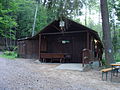
Edenkobener Hut at the Hüttenbrunnen
| Edenkobener Hut at the Hüttenbrunnen PWV Hut |
||
|---|---|---|
 Edenkobener Hut at the Hüttenbrunnen |
||
| location | Haardt (Palatinate Forest) ; Edenkoben - Südliche Weinstrasse district , Rhineland-Palatinate | |
| Mountain range | Palatinate Forest | |
| Geographical location: | 49 ° 17 '42 " N , 8 ° 3' 22" E | |
| Altitude | 367 m | |
|
||
| owner | Palatinate Forest Association | |
| Construction type | Hut; Sandstone, wood | |
| Usual opening times | daily with day off on Tuesday | |
| accommodation | 28 beds, 30 camps | |
| Web link | Edenkobener Hut at the Hüttenbrunnen | |

The Edenkobener Hütte am Hüttenbrunnen is a refuge in the Palatinate Forest managed by the Edenkoben local association of the Palatinate Forest Association . It is located in the southern part of the Haardt in the Edenkoben valley. The hut is at an altitude of 367 m .
history
A small rustic stone house was built in 1870. This has been owned by the Palatinate Forest Association since 1929. The house was expanded and restored over the years by the Edenkoben branch.
Access and walks
The hut is on the road from Edenkoben to the forester's house Heldenstein . There is a parking lot for hikers in the immediate vicinity. As a starting point for hikes, destinations can be reached via the Wegspinne in the south at Kohlplatz , the Wegspider in the north at the St. Martiner Hütte or Lolosruhe to the west . Access to the Kesselberg (662 m), the Frankenfelsen , the Modenbachtal and the Blättersberg (618 m) is possible via Kohlplatz . Destinations over the St.-Martiner hut can be the Hochberg (636 m) and the St.-Martiner valley. The Steigerkopf (613 m) can be reached via the Lolosruhe with the Schänzelturm . The neighboring huts of the Palatinate Forest Association are the Haus an den Fichten , the Totenkopfhütte , the Waldhaus Drei Buchen , the Amicitia-Hütte and the Schweizerhaus . Another nearby hiking hut is the Nellohütte . Due to the possibility of staying overnight, the hut is suitable as a station for long-distance hikes.
Picture gallery
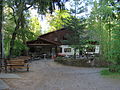
Edenkobener Hut
Otto Meyer Hut

Hüttenbrunnen - Ritterstein 235 below the hut


Individual evidence
- ^ LANIS: Topographic Map. Retrieved January 23, 2017 .
- ↑ tourenwelt.info
- ↑ Archive link ( Memento of December 8, 2012 in the Internet Archive )
literature
- AK Doerr: Palatinate Hüttenbuch - The guide to 99 rest houses and hikers' homes. 4th edition. Palatinate Publishing House Ludwigshafen, 2018, ISBN 978-3-87629-341-7 , p. 28.
- Matthias Wittber: Palatinate Forest with Bienwald. Bruckmann Verlag, 2009, ISBN 978-3-7654-4287-2 .
- State Office for Surveying and Basic Geographic Information Rhineland-Palatinate - topographic map 1: 25000 - Palatinate Forest Nature Park, sheet 6 Oberhaardt from Neustadt an der Weinstrasse to Queichtal. 2010, ISBN 978-3-89637-402-8 .
- Edenkoben - the holiday region between Landau and Neustadt. 1: 25000. Hiking and cycling map . 3. Edition. Pietruska Verlag, Rülzheim 2018, ISBN 978-3-945138-04-5 .
- Hauenstein & Trifelsland. 1: 25000. Hiking and cycling map . 3. Edition. Pietruska Verlag, Rülzheim 2017, ISBN 978-3-945138-02-1 .