
Hochberg (Haardt)
| Hochberg | ||
|---|---|---|
 |
||
| height | 635.3 m above sea level NHN | |
| location | at Sankt Martin ; Palatinate Forest , Rhineland-Palatinate ( Germany ) | |
| Mountains | Haardt | |
| Coordinates | 49 ° 17 '55 " N , 8 ° 4' 17" E | |
|
||

The high mountain is 635.3 m above sea level. NHN high mountain in the middle Haardt in the Palatinate Forest . It is located in the district of Sankt Martin in the Südliche Weinstrasse district in Rhineland-Palatinate ( Germany ). After the Kalmit ( 672.6 m ), the Kesselberg ( 661.8 m ) and the Roßberg ( 637 m ), it is the fourth highest mountain in the Palatinate Forest .
geography
location
The Hochberg rises in the Palatinate Forest Nature Park and in the Palatinate Forest-Vosges du Nord Biosphere Reserve . It is located south of the Breitenberg ( 545.2 m ) and Hüttenberg ( 620.1 m ) belonging to the Kalmit massif, between the Sankt Martiner valley in the north and the Edenkobener valley in the south. Its summit is 2.3 km west of Sankt Martin . The south-eastern pre-summit of the Hochberg is the Schraußenberg ( 582.6 m ). In the east, the mountain range slopes down to the Upper Rhine Plain , with the elevations of the Kropsburg ( 334.3 m ), Heidelberg ( 338.3 m ) and Werderberg ( 349.7 m ) with the Edenkoben monument to victory and peace in front. In the west, the mountain is connected to the Schafkopf ( 616.8 m ) via the saddle at the St. Martiner Hut ( 485.6 m ) .
To the north, the landscape of the Hochberg falls into the valley of the Kropsbach and to the southwest and south into that of the Triefenbach , both of which flow out of the Palatinate Forest into the Upper Rhine Plain to the east of this.
Natural allocation
The Hochberg belongs to the Palatinate Forest natural area, which is classified as a 3rd order Greater Region in the systematics of the handbook of the natural spatial structure of Germany published by Emil Meynen and Josef Schmithüsen and its subsequent publications . If you look at the internal structure of the natural area , it belongs to the Middle Palatinate Forest.
In summary, the natural spatial allocation of the Hochberg follows the following system:
- Greater region 1st order: Layer level land on both sides of the Upper Rhine Rift
- Greater region 2nd order: Palatinate-Saarland layer level land
- Greater region 3rd order: Palatinate Forest
- 4th order region (main unit): Middle Palatinate Forest
- 5th order region: Haardt
Summit and hiking
On the wooded high mountain there is a stone cone called the Steinernes Köppl . Not far from the summit is the chimney rock, from which a view of the Upper Rhine Plain is possible. It can be reached via marked hiking trails from the east from the Kropsburg or from the west from the Wegspinne at the St. Martiner Hütte.
Picture gallery

Blättersberg (left), Schraußenberg (center), Hochberg (right)

Hochberg with Sankt Martin in the foreground

Steinernes Köppl on the summit in summer

Steinernes Köppl on the summit in winter

Chimney rocks near the summit
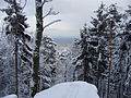
View from the chimney rock


Web links
Individual evidence
- ↑ a b LANIS: Hochberg on a topographic map from the map service of the landscape information system of the Rhineland-Palatinate nature conservation administration. Retrieved May 16, 2017 .
- ^ Federal Institute for Regional Studies: Geographical Land Survey. The natural space units in single sheets 1: 200,000 . Bad Godesberg 1952–1994. → Online maps , sheet 160: Landau i. d. Palatinate (Adalbert Pemöller, 1969; 47 pages)
- ↑ Helmut Beeger u. a .: The landscapes of Rheinhessen-Pfalz - naming and spatial delimitation. In: Reports on German regional studies , Volume 63, Issue 2, Trier, 1989, pp. 327–359