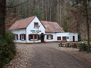
Amicitia Hut
| Amicitia Hut PWV Hut |
||
|---|---|---|
|
Amicitia Hut |
||
| location | Haardt (Palatinate Forest) ; Weyher in der Pfalz - Südliche Weinstrasse district , Rhineland-Palatinate | |
| Mountain range | Palatinate Forest | |
| Geographical location: | 49 ° 16 '39.5 " N , 8 ° 2' 38.9" E | |
| Altitude | 314 m above sea level NHN | |
|
|
||
| owner | Palatinate Forest Association | |
| Construction type | hut | |
| Usual opening times | Sunday and public holidays | |
| accommodation | 8 beds | |
| Web link | Homepage of the local association | |
The Amicitia Hut (also known as the Sieben Quellen Haus ) is a refuge in the Palatinate Forest that has been managed by the Amicitia Landau local association of the Palatinate Forest Association since 1921 . The hut is located at an altitude of 314 m above sea level. NHN .
location
The hut is located at the Siebenquelle, a small tributary of the Meisentalbach , which in turn is a left tributary of the Modenbach . The valley of the Siebenquelle is bordered in the north by the Kesselberg (662 m) and in the west by the Frankenberg ( 557 m above sea level ).
history
A first hut was built after the founding of the Amicitia social club in 1920 and subsequently with the registration as the Amicitia e. V. ” built in 1921. Due to the strong increase in membership, the hut was converted into a permanent forest house in 1925/1926. During the National Socialist era, the association was dissolved in 1937 and the hut was sold. Shortly after the end of the war, the association was re-established in 1946 and in 1948 the hut that had been destroyed by the effects of the war was bought back. Reconstruction then began in 1950. In the seventies, the hut was further converted and expanded. In 2013 the music and hiking club Amicitia joined the Palatinate Forest Association as the local group Amicitia Landau eV. The hut became a hut of the Palatinate Forest Association.
Access and walks
The hut can only be reached on foot. The shortest access is from a hiking car park in the Modenbachtal via a road leading to the hut. The hut can also be reached from the hiking car park in the Edenkobener Valley at the Edenkobener Hut at the Hüttenbrunnen via the Kohlplatz pass . Hiking destinations near the hut are the Frankenfelsen on the Frankenberg ( 557 m above sea level ) with the sparse remains of the Frankenburg , the Kesselberg (662 m), the second highest mountain in the Palatinate Forest after the Kalmit ( 672.6 m ), and the Blättersberg ( 618 m ) with the Ludwigsturm ( 605 m ). The neighboring huts of the Palatinate Forest Association are the Edenkobener Hut, the Schweizerhaus and the Waldhaus Drei Buchen . Other nearby hiking huts are the forester's house Heldenstein and the Nellohütte .
Individual evidence
- ↑ a b Homepage of the local association .
- ^ LANIS: Topographic Map. Retrieved January 23, 2017 .
- ↑ Amicitia Hut on Tourenwelt.de .
literature
- AK Doerr: Palatinate Hüttenbuch - The guide to 99 rest houses and hikers' homes . Pfälzische Verlagsanstalt Ludwigshafen GmbH, 4th edition June 2018, ISBN 978-3-87629-341-7 , p. 173.
- State Office for Surveying and Basic Geographic Information Rhineland-Palatinate: Topographic map 1: 25,000 - Palatinate Forest Nature Park, sheet 6 Oberhaardt from Neustadt an der Weinstrasse to Queichtal 2010, ISBN 978-3-89637-402-8 .
- Pietruska hiking map: Hauenstein & Trifelsland. 1: 25,000, 3rd edition, Pietruska Verlag, Rülzheim 2017, ISBN 978-3-945138-02-1 .

