Sedlecký potok (Mastník)
| Sedlecký potok | ||
|
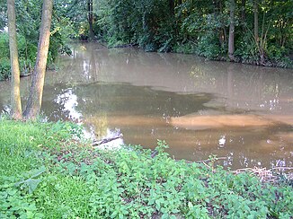
Estuary into the Mastník; the Sedlecký potok has heavily clouded water in the picture |
||
| Data | ||
| Water code | CZ : 1-08-05-052 | |
| location | Czech Republic | |
| River system | Elbe | |
| Drain over | Mastník → Vltava → Elbe → North Sea | |
| source | north of Kopaniny, Středočeská pahorkatina 49 ° 31 ′ 41 ″ N , 14 ° 33 ′ 5 ″ E |
|
| Source height | 625 m nm | |
| muzzle | in Sedlčany in the Mastník coordinates: 49 ° 39 ′ 18 " N , 14 ° 25 ′ 54" E 49 ° 39 ′ 18 " N , 14 ° 25 ′ 54" E |
|
| Mouth height | 340 m nm | |
| Height difference | 285 m | |
| Bottom slope | 13 ‰ | |
| length | 21.3 km | |
| Catchment area | 141.9 km² | |
| Drain |
MQ |
610 l / s |
The Sedlecký potok (German Sedletzer Bach ) is a right tributary of the Mastník in the Czech Republic .
course
The Sedlecký potok rises north of the Kopaniny single layer in the Jistebnice municipality in the Jistebnická vrchovina nature park. Its source lies west of the Holý vrch (677 m nm) or south of the Okrouhlík (658 m nm) in the Vlašimská pahorkatina ( Wlaschimer hill country ) belonging to the Central Bohemian hill country . Initially the stream flows south, after a short run it turns west and flows past Ostrý. There the Sedlecký potok changes its course to the northwest. Passing Jitra and Javoří, the brook leaves the nature park between Cunkov and Monín and flows through the hill country at the eastern foot of the Javorová skála (723 m nm); along its valley are the places Záhoří a Kozinec, Ounuz, Zahrádky and Moninec. Then the Sedlecký potok reaches the Sedlecká kotlina ( Sedletz Basin ) and flows north through Jetřichovice, Uhřice, Uhřický Mlýn and Sedlec and past Přestavlky and Prčice. Between Sedlec and Prčice, the listed Karl Burka Bridge ( Most Karla Burky ) has spanned the stream as the only connecting road between the two formerly independent towns. The course of the Sedlecký potok then leads in a north-westerly direction past Na Zavadilce, Měšetice, Lidkovice, Strnadovský Mlýn, Dobrošovice, Vršovice, Sovův Mlýn, Bolechovice and Doublovičky to Jesenice ; the stream flows through the Jistebnická vrchovina nature park again. Along the lower reaches follow Nedrahovice , Úklid, Lipský Mlýn, Bor, Rudolec, Přibýška, Klimětice, Nový Dvorek, Doubravice, Záduší, Šípkova Cihelna and Němečkova Cihelna. On the southern outskirts of Sedlčany , the Sedlecký potok is dammed in the Sedlčany retention basin. In the city, the state road I / 18 between Příbram and Kosova Hora bridges the stream. After 21.3 kilometers, the Sedlecký potok flows into the Mastník in Sedlčany near the train station .
Tributaries
- Cunkovský potok (l), below Záhoří a Kozinec
- Uhřický potok (l), in Uhřice
- Šanovický potok (r), in Sedlec
- Prčický potok (r), near Prčice
- Steblenecký potok (r), near Měšetice
- Divišovický potok (r), near Strnadovský Mlýn
- Hulínský potok (r), in Jesenice
- Novodvorský potok (l), in Jesenice
- Slabá (l), below Nedrahovice
- Radečský potok (r), near Lipský Mlýn
- Libíňský potok (l), near Rudolec
Flowing ponds
- Musík, at Moninec
- Pilský rybník, above Jetřichovice
- Lihovarský rybník, below Jetřichovice
- Uhřický rybník, above Uhřice
- Mlýnský rybník, near Uhřický Mlýn
- Dlouhý rybník, near Nedrahovice
Web links
Individual evidence
- ↑ a b c d Vltava a její přítoky - Sedlecký potok at kct-tabor.cz

