
Seebensee
| Seebensee | ||
|---|---|---|

|
||
| The Seebensee before the ascent to Ehrwalder Sonnenspitze | ||
| Geographical location | Mieminger Mountains ( Tyrol , Austria) | |
| Drain | Geissbach → Loisach | |
| Data | ||
| Coordinates | 47 ° 22 '6 " N , 10 ° 56' 3" E | |
|
||
| Altitude above sea level | 1657 m above sea level A. | |
| length | 400 m | |
| width | 200 m | |
| Maximum depth | approx. 30 m | |

The Seebensee is a natural high mountain lake (rock pool lake shaped by the Ice Age) at an altitude of 1,657 meters south of Ehrwald in the Mieminger Mountains . It is framed in the east by the Vorderen Tajakopf , in the south by the Vorderen Drachenkopf and in the west by the Ehrwalder Sonnenspitze .
The Seebensee has no significant above-ground inflow and an outflow via the Seebenbachfall and the Geißbach into the Loisach . The lake can be reached from Ehrwald on a forest path over the Ehrwalder Alm, over the Seeben via ferrata , a difficult via ferrata , or via one of the two secured mountain climbs Hoher Gang or Immensteig . From Biberwier the lake can be reached via the Biberwierer Scharte, from Leutasch through the Gaistal.
The managed Seebenalm is located near the lake (northeast). To the south, on a rocky terrace above the lake, is the Coburg Hut of the German Alpine Club .
The surface of the lake covers around 6.5 hectares , but used to be larger. By analyzing the soil and vegetation, it can be proven that a large area southeast of the lake (today as a mainly grassy plain, especially from a bird's eye view ) is a now silted up former part of the lake area.
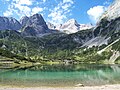
The Seebensee in front of the Vorderen Drachenkopf
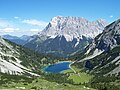
The Seebensee in front of the Wetterstein Mountains
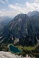
The Seebensee in front of the Vorderen Tajakopf


Web links
Individual evidence
- ^ Christian Wolkersdorfer: Mining on the Silberleithe. History, mineralization and formation of the lead-zinc deposits in the western Mieming Mountains. (PDF, page 59) Self-published, accessed on July 6, 2017 .
- ^ Christian Wolkersdorfer: Mining on the Silberleithe. History, mineralization and formation of the lead-zinc deposits in the western Mieming Mountains. (PDF, page 62) Self-published, accessed on July 6, 2017 .
Literature and map
- Tyrol . Compass digital map (referred to as No. K 4292 in the template). (1 DVD-ROM). Kompass-Karten-GmbH, Rum / Innsbruck 2007, ISBN 3-85491-995-6 .
- Alpine Club Map 1: 25,000, sheet 4/2, Wetterstein and Mieminger Mountains , ISBN 978-3-928777-20-9 .
- Helmut Pflanzelt: Wetterstein Mountains. A guide to valleys, huts and mountains . Attached work: Siegfried Aeberli: Mieminger chain . 2nd edition, reviewed and supplemented by the publisher. Alpine Club Guide , series: Northern Limestone Alps. Rother, Munich 1978, ISBN 3-7633-1113-0 .
- Ferd (inand) Kilger: Seebensee, Drachensee and Grünsteinscharte. With two woodcuts. In: Journal of the German Alpine Association / Journal of the German and (the) Austrian Alpine Association , year 1887, (Volume XVIII), pp. 313-316. (Online at ANNO ).