
Seichenkopf
| Seichenkopf | ||
|---|---|---|
 Seichenkopf |
||
| height | 1864 m above sea level A. | |
| location | Tyrol , Austria | |
| Mountains | Tannheimer Berge , Allgäu Alps | |
| Dominance | 1.6 km → Sefenspitze | |
| Notch height | 24 m ↓ notch to the Sefenspitze | |
| Coordinates | 47 ° 31 ′ 13 ″ N , 10 ° 34 ′ 20 ″ E | |
|
||
| Normal way | South ridge ( I ) | |

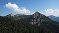
The Seichenkopf is an 1864 m above sea level. A. high mountain peaks in the Austrian part of the Allgäu Alps .
Location and surroundings
The summit, located in the Tannheimer Berge subgroup , forms the northern end point of the Lumberger Ridge ( 1860 m ). Its flanks drop to the west into the Engetal and to the north and east into the Sebental . The summit is only connected to the Lumberg ridge, initially to the south and then to the east. After its summit, the ridge descends in front of the Sefenspitze ( 1948 m ). This is reached via the Sefensattel in a northerly direction. Further to the east, the course descends towards the Füssener Jöchl ( 1818 m ), and from there it climbs to the Läuferspitze ( 1958 m ).
The border between the municipality of Grän in the west and the town of Vils in the east runs over the summit of the Seichenkopf and the Lumberger ridge .
The notch height of the Seichenkopf is at least 24 meters, its dominance 1.6 kilometers, with the Sefenspitze being the reference mountain.
Origin of name
The Seichenkopf was mentioned for the first time indirectly in the 17th century with the words " up to the Speicherwandt ... up into the Laumberg's Geschröff ", whereby the Speicherwand probably means a rock face on the northern flank of the Seichenkopf. The derivation of the name is based on August Kübler, who compares the shape of the mountain with that of an inverted "Saiche". A saiche is a tool for straining , i.e. filtering, milk. The broad foot of the mountain and the pointed summit are characteristic for this.
Ascent
The normal route to the Seichenkopf leads either over the Lumberger ridge into the notch between the two peaks or from the east from the valley floor at the Sebenalpe into the notch. From here, unmarked path tracks lead through Latschengassen and very easy, short rocky passages ( 1st degree of difficulty ) over the partially narrow south ridge to the summit. In the north flank there is the possibility of climbing (difficulty up to IV), including a lower summit cross that is difficult to reach.
photos

Transition from the Lumberger ridge

East flank
Northwest flank

Summit construction south side


Web links
References and comments
- ^ Federal Office for Metrology and Surveying Austria: Austrian Map online (Austrian map 1: 50,000) . Retrieved April 21, 2013.
- ↑ Exact value not known, stated value is a minimum value (can be up to 19 meters higher). It was determined from the distance between the contour lines (20 meters in altitude ) on a topographic map ( scale 1: 25,000).
- ^ Thaddäus Steiner : Allgäu mountain names . 2nd Edition. Kunstverlag Josef Fink, Lindenberg 2008, ISBN 978-3-8987-0389-5 (p. 193 f.).
- ^ A b Marcus Lutz: Alpine Club Guide - Tannheimer Berge . 2nd Edition. Bergverlag Rudolf Rother , Munich 1992, ISBN 978-3-7633-1239-9 (p. 122).
- ↑ Dieter Seibert: Alpine Club Guide alpine - Allgäu Alps and Ammergau Alps . 17th edition. Bergverlag Rother, Munich 2008, ISBN 978-3-7633-1126-2 (p. 236).