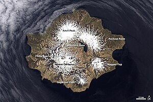
Semisopochnoi Island
| Semisopochnoi Island | ||
|---|---|---|
| Waters | Pacific Ocean | |
| Archipelago | Council of Iceland | |
| Geographical location | 51 ° 57 ' N , 179 ° 36' E | |
|
|
||
| length | 17 km | |
| width | 14 km | |
| surface | 221.7 km² | |
| Highest elevation | Anvil Peak 1221 m |
|
| Residents | uninhabited | |
| Eastern summit of Mount Cerberus | ||
Semisopochnoi Iceland ( Russian Семисопочный (in transliteration Semisopotschnoi ); "Unyax" or "Hawadax" in Aleut , German also: Rat Island ) is a the United States associated island in the western Aleutians .
The 221.7 km² island is the northeasternmost of the Council Islands . It lies between North America and Asia on the southern edge of the Bering Sea just west of the 180th degree of longitude.
The island, discovered by Vitus Bering in 1741 - as part of the Pacific Ring of Fire - is of volcanic origin, it has remained uninhabited to this day and offers ideal breeding conditions for many seabirds. The name Semisopochnoi comes from Russian and means "has seven hills".
The most active volcano is Mount Cerberus with a height of 774 m . The Sugarloaf Peak to the south of the island is 855 m high. The highest point is the 1221 m high Anvil Peak .
last activity
From February 14 to 16, 2020, seismic measurements detected explosions and tremors from the area of the island. However, due to bad weather and the remoteness of the island, no observation was possible.
Web links
- Semisopochnoi Island in the Geographic Names Information System of the United States Geological Survey
Individual evidence
- ↑ Managing Editor: Sally Kuhn Sennert: Global Volcanism Program, 2020. Report on Semisopochnoi (United States). In: Sennert, SK (ed.), Weekly Volcanic Activity Report, 12 February-18 February 2020. Smithsonian Institution and US Geological Survey. In: Smithsonian / USGS Weekly Volcanic Activity Report. February 18, 2020, accessed February 22, 2012 .


