Sheep River
| Sheep River | ||
|
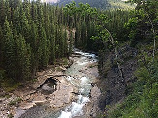
Upper reaches of the Sheep River in Sheep River Provincial Park |
||
| Data | ||
| location | Alberta (Canada) | |
| River system | Nelson River | |
| Drain over | Highwood River → Bow River → South Saskatchewan River → Saskatchewan River → Nelson River → Hudson Bay | |
| Headwaters | Misty Range ( Canadian Rockies ) 50 ° 40 ′ 6 ″ N , 114 ° 56 ′ 53 ″ W |
|
| Source height | approx. 2100 m | |
| muzzle |
Highwood River Coordinates: 50 ° 44 ′ 23 " N , 113 ° 51 ′ 18" W 50 ° 44 ′ 23 " N , 113 ° 51 ′ 18" W. |
|
| Mouth height | approx. 985 m | |
| Height difference | approx. 1115 m | |
| Bottom slope | approx. 10 ‰ | |
| length | approx. 110 km | |
| Catchment area | 1570 km² | |
| Discharge at the Okotoks A Eo gauge : 1490 km² Location: 15 km above the mouth |
MQ 2007/2015 Mq 2007/2015 |
9 m³ / s 6 l / (s km²) |
| Left tributaries | Bluerock Creek, Gorge Creek, Threepoint Creek | |
| Right tributaries | Junction Creek, Dyson Creek, South Coal Creek | |
| Small towns | Okotoks | |
| Communities | Turner Valley , Black Diamond | |
|
Course of the Sheep River |
||
The Sheep River is an approximately 110 km long left tributary of the Highwood River in the southwest of the Canadian province of Alberta .
River course
The Sheep River has its source in Elbow-Sheep Wildland Provincial Park in the Canadian Rockies . The headwaters are located on the northeast side of the Misty Range at an altitude of 2200 m . A few hundred meters further north is the upper reaches of the Elbow River . The Sheep River initially flows 10 km to the south-southeast. The river then turns east and breaks through the easternmost ridge of the Rocky Mountains. The Sheep River Provincial Park is located at the foot of the Rocky Mountains on the upper reaches of the river. This flows the rest of the way in an easterly direction through the prairie . The villages of Turner Valley and Black Diamond are located on the river. 15 km above the mouth, the Sheep River passes the small town of Okotoks . After another 8 km the Alberta Highway 2 ( Calgary - Fort Macleod ) crosses the river. This finally flows 8 km east of Okotoks into the Highwood River, 14 km above its mouth into the Bow River .
Hydrology
The Sheep River drains an area of 1570 km². The mean discharge is 9 m³ / s.

