Taunusblick settlement
The Taunusblick settlement is a post-war Frankfurt housing estate in the Zeilsheim district . The view of the Taunus mountains gave it its name. This prospect has hardly existed since the construction of noise barriers along the nearby motorway.
Location and development
The Taunusblick settlement covers an area of around 35 hectares and is located in northern Zeilsheim north of the Pfaffenwiese street or the Kolonie settlement , west of the Lachgraben or the Friedenau settlement, south of the federal motorway 66 and east of the historic location of Zeilsheim. The main street Pfaffenwiese connects the settlement to the regional road network. The Taunusblick settlement is connected to local public transport via the bus line running there and the Neu-Zeilsheim, Pfaffenwiese / Kolberger Weg, Zeilsheim and Lenzenbergstrasse stops . The inner development takes place via the collecting roads Lenzenbergstraße, Rombergstraße, Bechtenwaldstraße and the Pfortengartenweg. Pferdskopfweg and Hohe Kanzel are access roads.
Emergence
Numerous housing estates were built in Frankfurt am Main in order to meet the high demand for housing in the post-war period . The Taunusblick settlement was founded between 1950 and 1962 with funds from social housing by the non-profit housing and settlement company, a predecessor of the GWH Wohnungsgesellschaft mbH Hessen , the Nassauische Heimstätte , the non-profit joint stock company for rental housing (Mibau or ABG Frankfurt Holding ) and the Rhein- Main-Wohnen GmbH established. 237 buildings with 1750 apartments were built. At the end of 2008, 3,660 residents lived in the settlement.
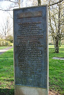
Before the construction of the settlement was located on the site during the time of National Socialism a labor camp for forced laborers for Hoechst of IG Farben , which as after the war camp for displaced persons was used. A memorial plaque in the central park in Bechtenwald reminds of this.
description
The Taunusblick settlement is designed as a purely residential area. It mainly consists of rows of buildings that run in a north-south direction, so that the apartments face east and west. The urban development concept was based on the nearby Wiesbadener Straße, which later became the Autobahn 66, as many of the rows of buildings were arranged at right angles to it. Generous green corridors structure the settlement. The buildings are mainly three or four storeys with a gabled roof covered. Six-story, point-shaped buildings are arranged on the northern edge between Lenzenbergstrasse and the motorway. Some areas are built with two-storey semi-detached or terraced houses that are privately owned. This also includes the area between Bechtenwaldstrasse and Pfaffenwiese, which is older than the Taunusblick settlement, as well as the development along the plow path and bowling alley.
Infrastructure
The Taunusblick settlement has social, sporting and church facilities as well as parks and allotment gardens. The Adolf Reichwein School in Lenzenbergstrasse is the primary school for the residential area. Five church and municipal childcare facilities are spread across the settlement. The Zeilsheim town hall, which serves the entire district, is located on the southern edge of the settlement. The home church in Rombergstrasse, which was formerly used by the Protestant parish, is now used by a Romanian community. As a replacement, a Protestant community center with a church hall was built on the corner of Lenzenbergstrasse and Pfaffenwiese in 2011. Pavilion buildings, which were formerly used as shops, are mostly empty. Two sports grounds are located in the east of the settlement. There and in the north there are five allotment gardens of two associations with around 155 gardens. Playgrounds are located within the green areas across the entire settlement.
References
literature
- Hans-Reiner Müller-Raemisch: Frankfurt am Main. Urban development and planning history since 1945. Campus-Verlag Frankfurt 1996, ISBN 3-593-35480-2
- Institute for Urban History : Collection of local history - Zeilsheim, newspaper articles and press releases since around 1950 , Frankfurt am Main
Web links
Individual proof
Coordinates: 50 ° 5 '57.9 " N , 8 ° 30' 0.7" E


