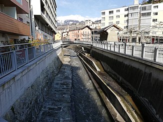
Sionne
| Sionne | ||
| Data | ||
| Water code | CH : 4051 | |
| location | Canton of Valais ; Switzerland | |
| River system | Rhone | |
| Drain over | Rhone → Mediterranean | |
| confluence | below the Chamossaire 46 ° 19 ′ 9 ″ N , 7 ° 23 ′ 6 ″ E |
|
| Source height | approx. 2580 m above sea level M. | |
| muzzle | in Sion in the Rhone coordinates: 46 ° 13 '44 " N , 7 ° 22' 10" E ; CH1903: 594670 / 119711 46 ° 13 '44 " N , 7 ° 22' 10" O |
|
| Mouth height | 486 m above sea level M. | |
| Height difference | approx. 2094 m | |
| Bottom slope | approx. 19% | |
| length | 11 km | |
| Catchment area | 27.64 km² | |
| Discharge at the estuary A Eo : 27.64 km² |
MQ Mq |
850 l / s 30.8 l / (s km²) |
| Left tributaries | Tsamaroude, Bisse de Clavau | |
| Right tributaries | Drahin | |
| Communities | Arbaz , Savièse , Sion | |
The Sionne is an 11 kilometer long right tributary of the Rhone in the Swiss canton of Valais . It flows through the Vallée de la Sionne , located below the Wildhorn , and flows into the Rhone in Sion (Sion).
See also
Web links
- Sionne on the ETHorama platform
Individual evidence
- ↑ a b Geoserver of the Swiss Federal Administration ( information )
- ↑ Hydrological Atlas of Switzerland of the Federal Office for the Environment FOEN, Table_13
- ↑ a b Modeled mean annual discharge. In: Topographical catchment areas of Swiss waters: sub-catchment areas 2 km². Retrieved August 25, 2017 .
