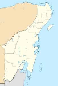
Sistema Ox Bel Ha
| Sistema Ox Bel Ha
|
||
|---|---|---|
| Location: | Quintana Roo , Mexico | |
|
Geographic location: |
20 ° 9 '36.5 " N , 87 ° 29' 17.1" W | |
|
|
||
| Geology: | limestone | |
| Type: | Water cave, stalactite cave | |
| Discovery: | 1996 | |
| Overall length: | 271.026 kilometers | |
| Level difference: | -57.3 meters | |
| Particularities: | world's second longest underwater cave | |
The Sistema Ox Bel Ha ( Spanish , Mayathan ; German "three water path system") is an underground river system in the Mexican state of Quintana Roo ( Yucatán Peninsula ) southwest of Tulum , the southern parts of which are in the Sian Ka'an Biosphere Reserve . With a measured 271 km (as of October 2019) it is the world's second longest known underwater cave system and the fourth longest system in total. It is connected to the surface by 143 cenotes . The average depth is 16 m (maximum 57.3 m). The halocline is about 13 meters deep; three of the six outflows to the Caribbean coast are diveable .
Travel history
| was standing | Length (km) |
Cenotes |
|---|---|---|
| 02/1996 | - | 1 |
| 01/1998 | 0.5 | 2 |
| 05/1998 | 12.1 | 6th |
| 04/1999 | 56.6 | 7th |
| 05/1999 | 70.3 | 14th |
| 02/2000 | 70.7 | 44 |
| 01/2002 | 94.5 | 56 |
| 09/2002 | 97.2 | 56 |
| 04/2003 | 107.1 | 60 |
| 03/2004 | 133.4 | 84 |
| 01/2005 | 133.6 | 86 |
| 06/2005 | 142.9 | 96 |
| 02/2006 | 144.7 | 98 |
| 07/2006 | 146.8 | 99 |
| 07/2007 | 164.5 | 128 |
| 11/2007 | 169.9 | 129 |
| 06/2008 | 172.3 | 130 |
| 05/2009 | 180.0 | 130 |
| 08/2010 | 182.1 | 131 |
| 03/2011 | 187.1 | 131 |
| 05/2011 | 222.3 | 131 |
| 06/2011 | 224.3 | 133 |
| 09/2011 | 228.9 | 136 |
| 10/2011 | 231.2 | 137 |
| 12/2011 | 232.8 | 137 |
| 02/2012 | 233.2 | 137 |
| 03/2012 | 233.4 | 137 |
| 04/2012 | 234.8 | 137 |
| 06/2012 | 238.2 | 140 |
| 08/2012 | 240.4 | 140 |
| 10/2012 | 242.3 | 140 |
| 12/2012 | 242.4 | 140 |
| 05/2013 | 243.6 | 140 |
| 06/2013 | 244.3 | 140 |
| 08/2013 | 256.7 | 140 |
| 05/2018 | 270.2 | 143 |
| 08/2018 | 271.0 | 143 |
| Source: | ||
After the discovery in 1996 ( ⊙ ), over 70 km were already measured in the first research phase (January 1998 to February 2000) and thus the Nohoch Nah Chich system, which was 61 km long at that time, was replaced. In 2011, the 25 km long Sistema Naranjal was connected to Ox Bel Ha.
In contrast to the longer known and more northerly located systems Sac Actun and Dos Ojos, further research was carried out for the first time using satellite images and GPS localization. This enabled new access points to be found quickly. Only the use of modern techniques, especially of diving scooters and rebreathers , the development has enabled some passages, such as the 5.5 kilometers from the Cenote Yaxchen to 700 m after the cenote Ma'Kai .
Web links
- Grupo de Exploración Ox Bel Ha (English, as of 2001)
Individual evidence
- ↑ a b Bob Gulden, Jim Coke: World longest underwater caves. In: Geo2 Committee on Long and Deep Caves. National Speleological Society (NSS), October 1, 2019, accessed December 26, 2019 .
- ↑ a b Long underwater caves in Quintana Roo Mexico. NSS, Quintana Roo Speleological Survey (QRSS) , July 18, 2019, accessed December 26, 2019 .
- ^ Bob Gulden: Worlds longest caves. In: GEO2 Committee on long and deep caves. NSS, December 2, 2019, accessed December 26, 2019 .
- ↑ List of Long Underwater Caves in Quintana Roo Mexico. QRSS, March 2, 2001, archived from the original on February 12, 2008 ; accessed on November 1, 2009 .
- ↑ Donna Richards, Simon Richards: Yaxchen and Ox Bel Ha, Quintana Roo . In: National Speleological Society, Association for Mexican Cave Studies (Ed.): AMCS Activities Newsletter . No. 30 . Austin 2007, p. 77–84 (English, cave-exploration.com [PDF; 5.5 MB ; accessed on June 8, 2016]).
