Skorpa (Herøy)
| Scorpa | ||
|---|---|---|
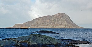
| Skorpa as seen from Gurskøya island | ||
| Waters | European Arctic Ocean | |
| Archipelago | Sørøyane | |
| Geographical location | 62 ° 20 ′ N , 5 ° 30 ′ E | |
|
|
||
| Highest elevation | Keipen 431 m |
|
| Residents | uninhabited | |
| Sørøyane archipelago | ||
Skorpa is an island in the Herøy municipality in western Norway .
The island is located west of Nerlandsøya and is separated from it by the Skorpasundet. The highest point on the island is the 431 m high Keipen.
Skorpa is no longer permanently inhabited, but the existing buildings on the island are still used as holiday homes.
Wild goats
When the people of Skorpa left the island, they left their goats on the island. Over time, these goats have feral and have multiplied in the free herd.
The island of Skorpa was an important contact point for the Shetland Bus during the Second World War .


