Solygeia
Solygeia ( Greek Σολυγεία , ancient Greek Σολύγεια ) was an ancient settlement in Corinthia . The municipality of Solygia was named after her.
Lore
According to Thucydides , the place was on the hill Solygeios and was unpaved. It was 12 stadiums (about 2 km) from the coast of the Saronic Gulf and was 20 stadiums (about 4 km) south of the Isthmus of Corinth and 60 stadiums (about 11-12 km) east of the ancient city of Corinth . The settlement was south of the ancient Corinthian port of Kenchreai on the other side of the Oneios Mountains . Based on this description, it is assumed that the place was on a hill 500 m west of the modern place Galataki .
The hill of Solygeios is said to have been inhabited during the Doric migration . The Dorians , who wanted to conquer the Peloponnese via the Isthmus of Corinth , had holed up here from the Aeolian population of Corinth. From here, Aletes is said to have gradually conquered Corinthia. 425 BC The Attic general Nikias landed here, between the foothills of Chersonese and the Rheiton river, and ravaged the country. It finally came to the battle of Solygeia , in which the Corinthians were able to drive out the Athenians with great losses.
When Lucius Mummius 146 BC When Corinth was destroyed, many residents fled here. However, Solygeia was destroyed by the Romans a short time later and never settled again.
Excavations
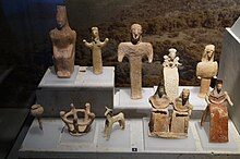
In 1957 and 1958 the archaeologist Nikolaos Verdelis carried out excavations near Galataki. He discovered an apsidal building 23 m long and 7 m wide 300 m southwest of the village . The entrance was on the east and the apse on the west. In front of the building, which was probably a temple, he found a Π-shaped burnt offering altar . The temple was built in the 8th century BC. Erected, rebuilt in the Archaic period and remained until the 5th century BC. In use. Based on the depot finds, which consist of over a thousand vases and clay figures, it is assumed that the goddess Hera was worshiped here. However, archaeologist Alexander Mazarakis Ainian refuses to identify the building as a temple.
About 50 m south of the building, Verdelis found six chamber tombs with dromos from the early Mycenaean period (1450–1400 BC). A burial chamber had collapsed and contained an undisturbed burial with ceramics from the Late Helladic period (SH II – IIIA). The collapsed burial chamber was later used as a dump. Here one discovered the depot finds described above. The other five graves were more or less disturbed and the Dromoi were damaged by the peasants' plow. The easternmost grave contained four corpses in good condition, but they are assigned to a more recent era. The westernmost grave contained an undisturbed burial from LH II. Corinthian shards from the 6th century BC lay above it. Also in the grave at the highest point was younger pottery - probably also from the 6th century BC. BC - deposited. A box grave had been dug in the dromos of a grave. In recent ceramics from the Geometric to the Classical period is enough, it is among other things omphalos bowls , Kalathiskoi , pyxides , monocotyledonous , poppy crop models and statuettes. Presumably it was deposited here during the ancestral cult .
At the highest point there were also four graves from Christian times.
Web links
Individual evidence
- ↑ Thucydides: The Peloponnesian War 4, 42-44
- ↑ Thucydides: The Peloponnesian War 4, 42
- ^ Conrad Bursian : Geography of Greece. Peloponnese and islands. , 1868–1872, p. 12 ( online )
- ↑ Thucydides: The Peloponnesian War 4, 42-45
- ^ Pausanias : Travels in Greece , 2, 1, 2
- ↑ Σολυγεία, το «μαργαριτάρι» του Σαρωνικού
- ↑ Konstantinos Kissas: Ancient Corinthia. Athens 2013, ISBN 978-960-6849-37-4 , pp. 85-86
- ^ Carla M. Antonaccio: An Archeology of Ancestors: Tomb Cult and Hero Cult in Early Greece . Rowman & Littlefield Publishers, Stuttgart, Berlin, Cologne 1994, ISBN 0-8476-7942-X , pp. 65–66 ( books.google.de [accessed August 26, 2018]).
- ^ Carla M. Antonaccio: An Archeology of Ancestors: Tomb Cult and Hero Cult in Early Greece . Rowman & Littlefield Publishers, Stuttgart, Berlin, Cologne 1994, ISBN 0-8476-7942-X , pp. 65-66 .
Coordinates: 37 ° 50 ′ 50 ″ N , 22 ° 58 ′ 20 ″ E

