Somersworth
| Somersworth | ||
|---|---|---|
|
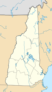
Location in New Hampshire
|
||
| Basic data | ||
| Foundation : | before 1700 | |
| State : | United States | |
| State : | New Hampshire | |
| County : | Strafford County | |
| Coordinates : | 43 ° 16 ′ N , 70 ° 52 ′ W | |
| Time zone : | Eastern ( UTC − 5 / −4 ) | |
| Residents : | 11,900 (as of 2017) | |
| Population density : | 459.5 inhabitants per km 2 | |
| Area : | 25.9 km 2 (approx. 10 mi 2 ) | |
| Height : | 62 m | |
| Postal code : | 03878 | |
| Area code : | +1 603 | |
| FIPS : | 33-69940 | |
| GNIS ID : | 0870007 | |
| Website : | www.somersworth.com | |
| Mayor : | Dana S. Hilliard (until 2020) |
|
Somersworth is a city ( City ) in New Hampshire in the United States . It's in Strafford County . The 2010 census found a population of 11,766.
geography
Somersworth lies on the right bank of the Salmon Falls River , which forms the border with the neighboring state of Maine . After Concord , the capital of the western New Hampshire is 55 km (straight line), after the southern Dover , the county seat, is eight kilometers away.
history
Somersworth was founded before 1700 and was registered as a town in 1754 . Since 1893 Somersworth has the status of a City .
Web links
Commons : Somersworth, New Hampshire - Collection of pictures, videos, and audio files
proof
- ^ Somersworth - Mayor & City Council website , accessed October 27, 2018
- ↑ American FactFinder - Somersworth City, New Hampshire , accessed October 27, 2018

Somersworth School Building (listed on the National Register of Historic Places )
