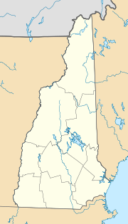
Dover, New Hampshire
| Dover | ||
|---|---|---|
| Nickname : The Garrison City | ||
|
Location in New Hampshire
|
||
| Basic data | ||
| Foundation : | 1623 | |
| State : | United States | |
| State : | New Hampshire | |
| County : | Strafford County | |
| Coordinates : | 43 ° 12 ′ N , 70 ° 53 ′ W | |
| Time zone : | Eastern ( UTC − 5 / −4 ) | |
| Residents : | 31,153 (as of 2016) | |
| Population density : | 450.2 inhabitants per km 2 | |
| Area : | 75.2 km 2 (approx. 29 mi 2 ) of which 69.2 km 2 (approx. 27 mi 2 ) are land |
|
| Height : | 15 m | |
| Postcodes : | 03820-03822 | |
| Area code : | +1 603 | |
| FIPS : | 33-18820 | |
| GNIS ID : | 0866618 | |
| Website : | www.ci.dover.nh.us | |
| Mayor : | Dean Trefethen | |
Dover is a city in the US state of New Hampshire . It is the administrative seat of Strafford County in the east of the state.
geography
The city has an area of 75.2 km², of which 69.2 km² is land and 6.1 km² (8.09%) is water. Dover is drained by the Cocheco River and Bellamy River . The city is 15 m above sea level, the highest point is Long Hill (Eng. "Long Hill") with 91 m height 5 km northwest of the city center.
history
Dover was founded as a municipality ( Town ) in 1623 and elevated to a City ( City ) in 1855 .
Personalities
sons and daughters of the town
- Conor Casey (* 1981), soccer player
- Thomas Mary O'Leary ( 1875–1949 ), Catholic clergyman, Bishop of Springfield
- Jenny Thompson (* 1973), swimmer
Personalities who were or are associated with Dover
- Jeremy Belknap (* 1744; † 1798), clergyman
- Daniel Meserve Durell (* 1769; † 1841), politician
- John P. Hale (* 1806; † 1873), politician
- Joshua G. Hall (* 1828; † 1898), politician
- Tommy Makem (1932 - 2007), musician
- Charles H. Sawyer (* 1840; † 1908), politician
- John Underhill (1597 - 1672), puritan
- John Wentworth (* 1745; † 1787), lawyer
Web links
Commons : Dover, New Hampshire - Collection of pictures, videos, and audio files
