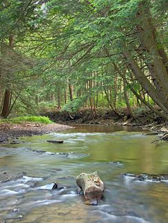
South Branch Tionesta Creek
| South Branch Tionesta Creek | ||
|
The river in the Allegheny National Forest in Sheffield Township |
||
| Data | ||
| Water code | US : 1210211 | |
| location | Pennsylvania ( USA ) | |
| River system | Mississippi River | |
| Drain over | Tionesta Creek → Allegheny River → Ohio River → Mississippi River → Gulf of Mexico | |
| origin | Confluence of the Wolf Run and Martin Run in the Highland Township 41 ° 35 ′ 37 ″ N , 78 ° 54 ′ 38 ″ W |
|
| Source height | 465 m | |
| muzzle | Confluence with the West Fork Tionesta Creek to Tionesta Creek Coordinates: 41 ° 40 ′ 35 ″ N , 79 ° 2 ′ 4 ″ W 41 ° 40 ′ 35 ″ N , 79 ° 2 ′ 4 ″ W |
|
| Mouth height | 397 m | |
| Height difference | 68 m | |
| Bottom slope | 3.2 ‰ | |
| length | 21 km | |
| Catchment area | 223.77 km² | |
| Left tributaries | Coon Run, Bogus Run | |
| Right tributaries | Fork Run, Cherry Run, East Branch Tionesta Creek | |
The South Branch Tionesta Creek is the 21 km long, left headwaters of the Tionesta Creek , which runs in the northwest of the US state Pennsylvania . It flows through a narrow valley in the Allegheny National Forest in Counties Elk , Forest and Warren . Its catchment area measures around 224 square kilometers.
course
The river is created by the confluence of its left source brook Wolf Run and its right source brook Martin Run at 465 m in the northeast part of the Highland Township in Elk County. After a short run to the southwest, the Coon Run , the longest tributary on the left, pours out from the left . After the confluence of the Chaffee Run immediately afterwards it turns to the northwest and after the confluence of the Crane Run reaches the Howe Township in Forest County from the right . He passes the Unincorporated community Brookston , where the Fork Run and the Bogus Run flow to him.
Shortly after Brookston, it crosses the Warren County border and now runs into Sheffield Township . From the right, the Cherry Run and the Martin Run as well as the East Branch Tionesta Creek shortly thereafter , before a small settlement follows on the river bank. It passes under the Pennsylvania State Route 666 and shortly afterwards, at 397 m a little south of Sheffield , together with the West Branch Tionesta Creek, forms the Tionesta Creek.
Individual evidence
- ^ Wolf Run in the Geographic Names Information System of the United States Geological Survey
- ^ South Branch Tionesta Creek in the Geographic Names Information System of the United States Geological Survey
- ↑ a b USGS National Map Viewer
- ^ Lycoming College Pennsylvania Gazetter of Streams (PDF)
