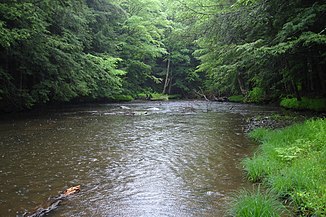
Tionesta Creek
|
Tionesta Creek, Teonista Creek, Teonista River |
||
|
Tionesta Creek in the Allegheny National Forest |
||
| Data | ||
| Water code | US : 1210221 | |
| location | Pennsylvania ( USA ) | |
| River system | Mississippi River | |
| Drain over | Allegheny River → Ohio River → Mississippi River → Gulf of Mexico | |
| origin | Confluence of West Branch Tionesta Creek and South Branch Tionesta Creek south of Sheffield 41 ° 40 ′ 35 ″ N , 79 ° 2 ′ 4 ″ W |
|
| Source height | 396 m | |
| muzzle | in the Allegheny River at Tionesta Coordinates: 41 ° 29 '6 " N , 79 ° 27' 27" W 41 ° 29 '6 " N , 79 ° 27' 27" W. |
|
| Mouth height | 320 m | |
| Height difference | 76 m | |
| Bottom slope | 0.81 ‰ | |
| length | 93.3 km (with West Branch) | |
| Catchment area | 1243 km² | |
| Discharge at the gauge at Lynch A Eo : 603.5 km² Location: 44 km above the mouth |
NNQ (1964) MQ Mq HHQ (1971) |
450 l / s 4.78 m³ / s 7.9 l / (s km²) 24.21 m³ / s |
| Reservoirs flowed through | Tionesta Lake | |
The Tionesta Creek is an approximately 93 km long left tributary of the Allegheny River in the northwest of the US state Pennsylvania . It runs mostly in the Allegheny National Forest and crosses the counties Warren and Forest . Its catchment area extends over an area of around 1240 square kilometers.
The word Tionesta comes from the Indian language and means something like "home of the wolves" or "it penetrates the island"
course
The river is created in the Allegheny National Forest by the confluence of West Branch Tionesta Creek and South Branch Tionesta Creek at 396 m just south of Sheffield in the area of Sheffield Township in Warren County. After a short river course mainly southwards it reaches the Forest County and now flows through the Howe Township in the north. Here it takes the Bluejay Creek from the left and turns first to the northwest. After the confluence of Minister Creek from the right at Mayburg , it turns to the southwest and shortly afterwards reaches Kingsley Township .
It passes Kellettville and takes up Salmon Creek from the left . This is followed by a short section in Green Township , where the river is dammed up to Tionesta Lake , the western part of which is in Tionesta Township . In this township, the Tionesta Creek finally flows into the Allegheny River from the left at 320 m directly at the Borough and County Seat Tionesta .
Web links
Individual evidence
- ↑ West Branch Tionesta Creek in the Geographic Names Information System of the United States Geological Survey
- ↑ Tionesta Creek in the Geographic Names Information System of the United States Geological Survey
- ↑ United States Army Corps of Engineers: Report of the Chief of Engineers US Army, Part 1, Volume 2 . US Government Printing Office, 1938, pp. 2195 ( Tionesta Creek on p. 1268 in the Google book search).
- ^ Lycoming College Pennsylvania Gazetter of Streams (PDF)
- ↑ United States Geological Survey ; USGS 03017500 Tionesta Creek at Lynch, PA ; accessed on October 23, 2016.
- ^ Federal Writers' Project: The WPA Guide to Pennsylvania: The Keystone State . Trinity University Press, October 31, 2013, pp. 660 ( Tionesta on p. 575 in the Google book search).
