
Southwest National Park
| Southwest National Park | |||
|---|---|---|---|
|
|
|||
|
|||
| Location: | Tasmania , Australia | ||
| Specialty: | completely untouched mountain, river and coastal landscapes | ||
| Next city: | Strathgordon | ||
| Surface: | 6,052 km² | ||
| Founding: | 1955 (as Lake Pedder NP) | ||
| Address: |
Southwest National Park (for entrance via Maydena) 66 Lake Dobson Road National Park TAS 7140 |
||
 |
|||

The Southwest National Park (German: Southwest National Park ; English Southwest National Park ) is located in the southwest of the Australian island of Tasmania .
description
geography
The eastern border of Tasmania's largest national park is about 95 km from Hobart . The park with a total area of 6052 km² extends over large parts of the southwest of the island. It was originally founded in 1955 under the name Lake Pedder National Park around Lake Pedder . After repeated enlargements of the park, it finally got its current name in 1990. It is now Tasmania's largest national park and is a UNESCO World Heritage Site of the Tasmanian Wilderness .
Mount Anne on the north edge of the park is the highest point at 1,423 m.
The park is known for its wilderness and seclusion. The weather is very changeable and rough. Aborigines settled here 25,000 years ago, and the Europeans first entered this area in the 19th century. Since then there have hardly been any permanent residents and consequently only minor influences on nature.
There is only one road in the entire park, it leads to Strathgordon . The southern and western parts of the park can only be reached on foot, boat or by air. The tarmac in Melaleuca , in the far south-west, is mainly used by the National Parks Service . Access by sea is best done through Port Davey or Bathurst Harbor .
fauna
Southwest National Park is the primary breeding ground for the critically endangered golden-bellied parakeet , which is most easily seen by park visitors near Melaleuca .
Hiking trails
Two main hiking trails lead through the park. One runs from Lake Pedder to Melaleuca, the other from Cockle Creek to Melaleuca. The hikes are only recommended for experienced hikers, as together they take about ten to 14 days. With a flight to Melaleuca you can split up the hike, or just set out from there for day hikes. There are also other, mostly very demanding, hiking trails. They lead to the west and east of the Arthur Range , Precipitous Bluff, the Southwest Cape and Federation Peak , possibly the most difficult and demanding hiking trail in Australia.
Short hikes
- Creepy Crawly Trail (20 minutes there and back)
- Huon Campground or exit of the Port Davey Track (60 to 120 minutes there and back)
Day hikes
- Eliza Plateau (5 to 6 hours there and back)
- Mount Anne (8-10 hours there and back)
- Lake Judd (6 hours there and back)

Mount Rugby and Bathurst Harbor

Small aircraft on the Melaleuca tarmac
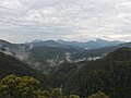
View into Southwest National Park from Scott's Peak Road


literature
- Moon, R. and Moon, V. (Eds) (2000) Discover Australia: National Parks. Sydney: Global Book Publishing Pty Ltd.
See also
Web links
- official site of the park (English)
- Walking the South-West (English)
- Airline with flight to Melaleuca (English)
- Airline with flight to Melaleuca (English)
Individual evidence
A Asbestos Range | B Ben Lomond | C Cradle Mountain-Lake St Clair | D Douglas Apsley | F Franklin Gordon Wild Rivers | Freycinet | H Hartz Mountains | K Kent Group | L Lake Pedder | M Maria Island | Mole Creek Karst | Mount Field | Mount William | N Narawntapu | R Rocky Cape | S Savage River | South Bruny | Southwest | Strzelecki | T Tasman | W Walls of Jerusalem