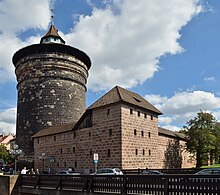
Spittlertor
The Spittlertor is an old gate in the southwest of the Nuremberg city wall . The name refers to what was then the nearby St. Elisabeth Hospital .
The Spittlertorturm, one of the four distinctive, round main towers of the Nuremberg city fortifications, is named after the Elisabeth Hospital of the Teutonic Order , its old name after the seven-colored alphabet is “Red Q”.
The gate is already occupied as part of the last city wall in 1377 and replaced the gate tower of the penultimate city wall, the White Tower , formerly called Inneres Spittlertor . The associated road led in the direction of Schwabach , Rothenburg ob der Tauber and Donauwörth . The structure was converted into the still standing round tower by Jörg Unger in 1557 , and a new gate was built next to it. At the end of the 19th century the facility was rebuilt and adapted to the requirements of the growing traffic; further arches were built and the moat was dammed. The archway built in the process was destroyed in the Second World War.
During the Second World War, the tower was used as a bunker after renovations; since July 2006 it has housed the library and archive of the Nuremberg Garrison Museum . The armory of the gate is empty today.
The wall area between Spittlertor and Westtor is called the Spittlertormauer . Thereafter, the street inside the wall was named Spittlertormauer and the main road outside it was named Spittlertorgraben . Both lead north. To the east of the gate, the Nuremberg red light district extends along part of the Frauentormauer .
Historical illustrations
The Spittlertor in Nuremberg , watercolor (1856) by Rudolf von Alt
Individual evidence
- ↑ [1]
- ^ Helge Weingärtner: Spittlertor . In: Michael Diefenbacher , Rudolf Endres (Hrsg.): Stadtlexikon Nürnberg . 2nd, improved edition. W. Tümmels Verlag, Nuremberg 2000, ISBN 3-921590-69-8 , p. 1009 ( complete edition online ).
- ^ Garrison Museum Nuremberg | bayern-on-the-web. Accessed April 12, 2018 (German).
Web links
- View of the Spittlertor in the map (1628/31) by Hans Bien
Coordinates: 49 ° 26 '53.9 " N , 11 ° 4' 0.6" E


