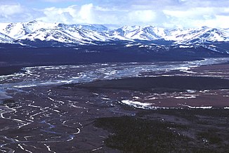
Squirrel River
| Squirrel River | ||
|
Squirrel River in the Baird Mountains |
||
| Data | ||
| Water code | US : 1896787 | |
| location | Alaska (USA) | |
| River system | Kobuk River | |
| Drain over | Kobuk River → Arctic Ocean | |
| source | Baird Mountains ( Brooks Range ) | |
| muzzle |
Kobuk River , near Kiana Coordinates: 66 ° 58 ′ 26 ″ N , 160 ° 25 ′ 0 ″ W 66 ° 58 ′ 26 ″ N , 160 ° 25 ′ 0 ″ W |
|
| Mouth height |
9 m
|
|
| length | approx. 150 km | |
| Catchment area | 4150 km² | |
| Communities | Kiana | |
The Squirrel River is an approximately 150 km long right tributary of the Kobuk River in northwest Alaska .
Its source is on the southern flank of the Baird Mountains , a mountain range of the Brooks range , between Noatak National Preserve and Kobuk Valley National Park . It flows in a south-easterly direction and flows into the Kobuk River at Kiana , which flows over the Kotzebue Sound to the Chukchi Sea , a marginal sea of the Arctic Ocean .
The name of the river goes back either to "Sikrikpak", the name of the indigenous people of Alaska for the ice gray marmot , or to "Sikrik", the name for a type of real ground squirrel . In 1884, Lieutenant Cantwell of the United States Revenue Cutter Service noted the name “Sheeleelicktok” and a year later “Shee-gar-rik-puk” and “Shee-lee-lie-tok”. In 1900, Lieutenant Stoney of the United States Navy documented the designation "Shu-shuk-to-ark".
Individual evidence
- ↑ Squirrel River in the Geographic Names Information System of the United States Geological Survey
- ↑ Bureau of Land Management (PDF) ( Memento of the original from April 19, 2014 in the Internet Archive ) Info: The archive link was inserted automatically and has not yet been checked. Please check the original and archive link according to the instructions and then remove this notice.
