St. Leonhard am Walde
|
St. Leonhard am Walde ( cadastral ) village of St. Leonhard am Wald |
||
|---|---|---|
|
|
||
| Basic data | ||
| Pole. District , state | Waidhofen an der Ybbs (WY), Lower Austria | |
| Judicial district | Waidhofen an der Ybbs | |
| Pole. local community | Waidhofen an der Ybbs | |
| Coordinates | 47 ° 59 '44 " N , 14 ° 52' 31" E | |
| Area d. KG | 18.68 km² | |
| Statistical identification | ||
| Locality code | 03281 | |
| Cadastral parish number | 03327 | |
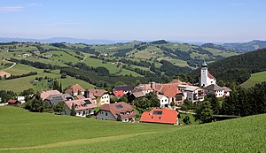
 Southwest view of St. Leonhard am Wald |
||
| Source: STAT : index of places ; BEV : GEONAM ; NÖGIS | ||
St. Leonhard am Walde is a cadastral community and in the spelling St. Leonhard am Wald a place in the statutory city of Waidhofen an der Ybbs in Lower Austria .
The Kirchenweiler is located on an elevated point in the surrounding hilly landscape of the Mostviertel and northeast of the town of Waidhofen an der Ybbs . The place was mentioned in a document in 1443. Originally St. Leonhard am Wald was an independent municipality and was incorporated into Waidhofen in 1972.
Settlement development
At the turn of the year 1979/1980 there was a total of 244 building areas with 69,669 m² and 126 gardens on 434,681 m² in the cadastral community of St. Leonhard am Walde, in 1989/1990 there were 240 building areas. In 1999/2000 the number of building areas had increased to 275 and in 2009/2010 there were 225 buildings on 304 building areas.
history
The Kirchweiler was first mentioned as a subsidiary of Neuhofen in 1435 and a church was consecrated in 1443. In 1778 the place became a vicariate and in 1939 it became an independent parish.
Culture and sights
- Parish church of St. Leonhard am Wald : The parish and pilgrimage church consecrated to St. Leonhard is a late Gothic hall church with a slightly retracted choir, visible from a high point . The mighty west tower presented dates from the 15th century and has a baroque dome .
Agriculture
The cadastral community is characterized by agriculture. 1,410 hectares were used for agriculture at the turn of the year 1979/1980 and 382 hectares were forest areas. In 1999/2000 agriculture was carried out on 1,338 hectares and 466 hectares were designated as areas used for forestry. At the end of 2018, 1,310 hectares were used as agricultural land and forestry was carried out on 473 hectares. The average soil climate number of St. Leonhard am Walde is 21.2 (as of 2010).

