
City fortifications of Chiang Mai

The city fortifications of Chiang Mai ( Thai กำแพง เมือง เชียงใหม่ ) are located in Chiang Mai , the capital of the district of the same name Amphoe Mueang Chiang Mai and the province of Changwat Chiang Mai in the north of Thailand . As soon as the city was founded in 1296, work on the city fortifications began. In its current form, however, the fortification goes back to the turn of the 18th to the 19th century, when the corner bastions in particular were added after the withdrawal of the Burmese to counter a renewed Burmese threat.
history

According to tradition, the construction of the city fortifications of Chiang Mai in connection with the establishment of Chiang Mai as the new capital of the kingdom of Lan Na was ordered by King Mengrai and started on April 12, 1296. 90,000 men are said to have been involved in the work for four months. Some of the city gates were not added until the 14th and early 15th centuries. Regular maintenance work was carried out until the Burmese conquered Chiang Mai in 1556. These ceased to exist only during the more than two hundred years of Burmese rule over the city (1556 to 1775). After their withdrawal, the fortifications were again restored and strengthened at the end of the 18th / beginning of the 19th century. In particular, the corners of the city walls were provided with mighty bastions protruding outwards, and the city fortifications were given the appearance that in some parts still presents itself to visitors today. The last repair took place around 1880.
A massive destruction of the masonry took place during the Second World War, when Japanese troops demolished large parts of the city walls in order to use the stones for secondary purposes in road construction. A partial reconstruction of the walls, gates and bastions was then carried out from the 1970s. In 2015, Chiang Mai, with its monuments, archaeological sites and the surrounding cultural landscape, was placed on the list of candidates for UNESCO World Heritage Sites . Since then, the former fortification of the city has also been a special focus of Thai monument preservation .
Structure and functions
The city fortifications of Chiang Mai measure around 1,800 m by 2,000 m in an approximate rectangle and thus cover an area of around 3.6 square kilometers. It consists of a moat, which was originally 18 meters wide, and a brick wall. Of the up to six gates that were built in the meantime, also made of bricks, five are still visible today. In front of the gates, bridges made of bamboo crossed the moat. In the event of a threat, these lightweight bridges could be quickly cleared. The four corners of the fence were covered with brick bastions , of which the eastern one had a square, while the western one had a round-oval floor plan.
In addition to its task of military protection of the city, the city fortifications fulfilled other functions and formed one of the focal points of city life. Until the Second World War, the city gates were the only well-guarded accesses to the city that were only open from sunrise to sunset, so that customs duties had to be postulated. Markets were held regularly at all city gates.
The following special structures of the city walls - city gates and bastions - are listed in clockwise order, starting with the north gate:
Pratu Chang Phueak (North Gate)
The north gate was originally called Pratu Hua Vieng, which means "first gate to enter the city". It was renamed around 1400 and received its name, which is still in use today, Pratu Chang Phueak ( ประตู ช้างเผือก ), "gate of the white elephant" . The white elephant plays an important role in urban mythology: According to tradition, a relic of the Buddha brought to Chiang Mai by the monk Sumana from Sukhothai in 1371 was kept in the chedi of Wat Suan Dok . One day this parted miraculously. To find a place for the new relic, it was attached to the back of a white elephant, which was then released. The elephant marched through the north gate to Mount Doi Suthep and climbed it. After a three-day hike, he came to a ledge under which the hermit Wasuthep lived. There the elephant trumpeted three times, turned three times in a circle, knelt and perished. For the relic, the Wat Phra That Doi Suthep was built at this point .
The guardian deity of the gate is Chang Phueak Khantharakhito, who can be equated with the Vedic god Kubera .
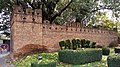
Chaeng Si Phum (Northeastern Bastion)
Chaeng Si Phum ( แจ่ง ศรี ภูมิ ) is a massive brick bastion with a square floor plan, protruding outwards from the wall, which was added to the fence around the turn of the 18th to the 19th century under King Chao Kawila . The name Si Phum means “glory of the country” and goes back to a mythological cosmology of the city, which assigned certain properties to certain points of the city's topography in a magical context.
Not far from the Si Phum bastion was another city gate in the 15th and early 16th centuries, the Pratu Si Phum, which was built by King Tilokarat in 1465 in order to gain direct access to his palace from outside the city walls. Under his successor, Phrachao Yot Chiang Rai , the gate was abandoned again in 1517 and the city wall was rebuilt at this point as part of a broad-based repair work on the entire city wall.
- Pratu Chang Phueak and Chaeng Si Phum

Pratu Chang Phueak
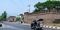
Pratu Chang Phueak

Chaeng Si Phum
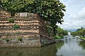
Chaeng Si Phum

Chaeng Si Phum

Chaeng Si Phum


Pratu Tha Phae (East Gate)
The eastern gate was originally called Pratu Chiang Ruak, named after a neighboring town. It was not renamed Pratu Tha Pae ( ประตู ท่าแพ ) until the 19th century , which means “gate to the harbor with the houseboats”, according to other sources, “gate to the raft landing site”. The port or land was in an easterly direction, about a kilometer away on Mae Nam Ping in the area of today's Nawarat Bridge. The guardian deity of this gate is Tha Pae Surakkhito, who corresponds to the Vedic god Indra .
The recent city gate is a modern reconstruction based on a photograph from 1891. The spacious square east of the gate is now used as a meeting place for young people, for taking wedding photos for newlyweds from all over the world and for organizing various festivities.
Chaeng Katam (Southeastern Bastion)
Chaeng Katam (also: Khatam; แจ่ง ก๊ะ ต้ำ or แจ่ง ขะ ต๊ำ ) is like Chaeng Si Phum a brick bastion with a square floor plan that protrudes outward from the wall. Like all other citadels, it was added to the fortification at the turn of the 18th and 19th centuries under Chao Kawila.
The name Katam means "fish trap" and indicates the fact that the ditch at this corner of the city walls was drained in the direction of Mae Nam Ping, so that a particularly large amount of fish could be caught there due to the nutrient-rich sewage.
- Pratu Tha Phae and Chaeng Katam

Pratu Tha Phae

Pratu Tha Phae

Pratu Tha Phae

Pratu Tha Phae

Chaeng Katam

Chaeng Katam


Pratu Chiang Mai (Southeast Gate)

The guardian deity of the southeast gate is Chiang Mai Choeyaphumo, who corresponds to the Hindu god Yama .
Pratu Saen Pung (South West Gate)
Pratu Saen Pung (also: Pratu Suan Prung; ประตูแสน ปุ ง or ประตู สวน ปรุง ) is one of the city gates mentioned in the chronicles, which were only built later, possibly in the early 15th century, under King Sam Fang Kaen . The reason may have been that the king's mother was able to better supervise the stagnant construction work at Wat Chedi Luang through this gate from the palace .
As with Pratu Chiang Mai, Chiang Mai Choeyaphumo is also the guardian deity of this south-facing gate. Following the Brahmin tradition that the south is the direction of death, Pratu Saen Pung was the gateway for funeral processions. In addition, the square in front of this city gate served as a place of execution for rebels in earlier times. They were tied to a stake, their belly pierced with a spear, and left to die. This is possibly the linguistic analogy to the name Saen Pung, which, depending on whether Saen is used as a verb or a noun, can be translated as “acting against the belly” or as “park of the bellies”.
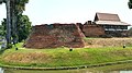
Chaeng Ku Rueang (Southwest Bastion)
Chaeng Ku Rueang (also: Ku Hueang; แจ่ง กู่ เรือง or แจ่ง กู่ เฮื อง ) is a massive brick bastion from around 1801 that protrudes outward from the wall and has a rounded / oval floor plan.
The name Ku Rueang has the meaning of "A structure similar to a chedi containing the ashes of the Ruang (proper name)". Mun Rueang was the name of the officer on watch who guarded Prince Khrua, a son of King Mengrai, who was imprisoned here from 1321 to 1325, and who also owned a house here. The citadel's name may refer to this historical episode.
- Pratu Chiang Mai, Pratu Saen Pung and Chaeng Ku Rueang

Pratu Chiang Mai

Pratu Saen Pung

Pratu Saen Pung

Chaeng Ku Rueang

Chaeng Ku Rueang
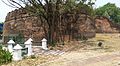
Chaeng Ku Rueang


Pratu Suan Dok (West Gate)
The name Pratu Suan Dok ( ประตู สวน ดอก ) means "gate of the flower garden". In 1371, the ruler Kue Na donated part of the previously royal gardens to the respected Buddhist monk Sumana and built Wat Suan Dok there . The path leading west from the city gate connected the city to this monastery. The guardian deity of this city gate is Suan Dok Sarachato, who corresponds to the Indian god Varuna .
Chaeng Hua Lin (Northwest Bastion)
Chaeng Hua Lin ( แจ่ง หัว ลิ น ), like Chaeng Ku Rueang, is a brick bastion built around 1801 with a rounded / oval floor plan that protrudes outward from the course of the wall. The name Hua Lin means source of water and refers to the fact that the moat of Mae Nam Huai Kaeo received its water inlet at this corner of the city wall.
- Pratu Suan Dok and Chaeng Hua Rin
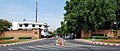
Pratu Suan Dok

Pratu Suan Dok

Pratu Suan Dok
Pratu Suan Dok
Chaeng Hua Lin

Chaeng Hua Lin


literature
- Michael Freeman: Lanna - Thailand's Northern Kingdom . River Books, Bangkok 2001, ISBN 0-500-97602-3
- Paisarn Tepwongsirirat: The Changing Function of Chiang Mai City Wall . Cornell University, Ithaca (NY) 2002
- Abha Bhamorabutr: The story of Chiengmai . Bangkok 1980
Web links
- Brian Hubbard: The Gates of Chiang Mai . SP Publishing Group Co., Ltd., Chiang Mai 2008, accessed on May 5, 2017
Individual evidence
- ↑ a b c d e f Brian Hubbard: The Gates of Chiang Mai . SP Publishing Group Co., Ltd., Chiang Mai 2008, accessed on May 5, 2017.
- ↑ a b c Michael Freeman: Lanna - Thailand's Northern Kingdom . River Books, Bangkok 2001, ISBN 0-500-97602-3 , p. 82.
- ↑ a b Michael Freeman: Lanna - Thailand's Northern Kingdom . River Books, Bangkok 2001, ISBN 0-500-97602-3 , pp. 62-64.
- ↑ Location of Pratu Chang Phueak: 18 ° 47 ′ 43.25 ″ N , 98 ° 59 ′ 11.7 ″ E
- ↑ Michael Freeman: Lanna - Thailand's Northern Kingdom . River Books, Bangkok 2001, ISBN 0-500-97602-3 , 3, pp. 101-105.
- ↑ a b c d e f Michael Freeman: Lanna - Thailand's Northern Kingdom . River Books, Bangkok 2001, ISBN 0-500-97602-3 , p. 83.
- ↑ Michael Freeman: Lanna - Thailand's Northern Kingdom . River Books, Bangkok 2001, ISBN 0-500-97602-3 , p. 85.
- ↑ Location Chaeng Si Phum: 18 ° 47 ′ 42.9 ″ N , 98 ° 59 ′ 37 ″ E
- ↑ location Pratu Tha Phae: 18 ° 47 '15.95 " N , 98 ° 59' 35.65" O
- ↑ Per Sundberg: The stones are alive on The Northern Rose , accessed on May 7, 2017.
- ↑ Michael Freeman: Lanna - Thailand's Northern Kingdom . River Books, Bangkok 2001, ISBN 0-500-97602-3 , pp. 83f.
- ↑ a b c d Michael Freeman: Lanna - Thailand's Northern Kingdom . River Books, Bangkok 2001, ISBN 0-500-97602-3 , p. 84.
- ↑ Brian Hubbard to Abha Bhamorabutr: The story of Chiang Mai . Bangkok 1980 on The Gates of Chiang Mai . SP Publishing Group Co., Ltd., Chiang Mai 2008, accessed on May 5, 2017.
- ↑ Information board on site.