
City Park (Kempten)
_(1).jpg)

The city park in Kempten (Allgäu) is a centrally located green area . It was built in the 1890s instead of a meadow and was intended to connect the former imperial and monastery town of Kempten, which had only been united into one town since 1818. The layout of the park at this point was part of the town planning of the then mayor Adolf Horchler .
location
The 2.5 hectare city park extends from the northern Zumsteinhaus to the Parktheater in the south. The city park is bordered to the west by the Harmonie building (today the tax office) and to the east by the Lyceum with the central transfer point "ZUM". The main office of the Sparkasse Allgäu is located in close proximity to the park . The former area name Schwaigwiese indicates a cattle yard with the associated pasture area.
history
Until the secularization in 1802/3 and the final unification of the imperial and monastery town of Kempten into one town in 1818, the area of the later town park was a buffer zone between the two towns of the same name. After that, the Schwaigwiese, as the area was called earlier, served the garrison of the vigilante group, which was disbanded in 1869, as a shooting and training area.
In 1874 the city of Kempten was able to acquire the meadow from the Bavarian military. The residents of the city could no longer accept the noise from the gunshots. The military then moved to Riederau , an area east of the Iller . The area there, about 96 Bavarian day works, was the city's exchange offer to the military. It took over a decade before the city was able to decide on a usage concept for the Schwaigwiese. Due to the Kempten main train station and the settlement of the areas west of the Schwaigwiese, the area came more into the city center, and thus also in the eye of city planners.
In 1887 there was a local political conflict over the future use of the fallow Schwaigwiese. Considerations of creating a park out of the Schwaigwiese were rejected by representatives of the cattle market that regularly takes place there. At times, a development with residential houses was also considered. A large number of citizens and city councilors agreed that the area should best be reserved for farmers with their cattle and pig trade. However, after long discussions, the mayor Adolf Horchler prevailed. A new cattle trading center was to be built east of the station. On September 15, 1887, the magistrate decided in favor of the new street layout with the extended Bodmanstrasse as an east-west axis. According to Horchler's request, the Schwaigwiese was not built over, but instead laid out as a park landscape in the English style, including a parade, market and assembly area.
Between 1891 and 1893, according to the plans of the horticultural inspector, garden architect and director of the Munich Botanical Garden, Max Kolb (1829–1915), the father of the poet Annette Kolb, and the later city gardener of Kempten, Dominikus Senn, a pupil of Kolb, the city park designed. In the plans, the project was called "Plant on the Schwaigwiese".
During the work, around 5,000 bushes and trees were planted and major earth movements were made. For this, the wall in front of the moat of the former imperial city had to be removed and the area leveled. Compared to the park of the 1990s, the completed facility comprised a much larger area. The city park was equipped with a grotto, a small pond with a waterfall and later with a pavilion and fountain. Visitors praised the city park as a “little tree paradise” or as the “lung of Kemptens”. In 1900 the Königsplatz served as an ice rink.

The first cut into the park was made in 1937 when the gymnasium - now a listed building - was built on Königsplatz and the alpine garden was removed. After the Second World War, the city park was used for the black market until the introduction of the Deutsche Mark in 1948. For the Allgäu Festival Week , tents have been set up in the city park every August since 1949 and the area is fenced off. In 1991 a two-story underground car park was built under the Königplatz; the large gravel area was then converted into a parking lot. In 1995 a central bus transfer point ( ZUM ) of the Verkehrsgemeinschaft Kempten was built in front of the Lyceum ; shortly before, when the lyceum was being rebuilt, the green space there had been removed and two large copper beeches and a linden tree felled.
The city park was extensively redesigned from autumn 2018 to autumn 2019.
Buildings and small architecture

On November 21, 1890, the war memorial at the Lyceum was unveiled. The bronze casting designed by the Pfronten academy professor Syrius Eberle (1844–1903) depicts an angel of peace handing a wreath to a dying warrior. The memorial was melted down during World War II.
In 1904 a music pavilion was built from the foundation of the late patron of culture Christian Marco Calgèer . The roof of the classical building is supported by eight columns, which stand on an octagonal base. The roofed floor area is made of terrazzo and bears a mosaic with the Kempten city coat of arms in the middle. During the Allgäu Festival Week, a temporary radio studio from Bayerischer Rundfunk BR or the local broadcaster RSA is usually set up in the pavilion.
The Kempten Jews in the time of Nazism two reminders and monuments commemorate the north of the park.

Music pavilion
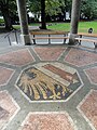
Kempten city arms in the music pavilion

Inscription in one of the stones of the pavilion

View of the park from the northeast

Northern part of the city park or parts of the Zumsteingarten
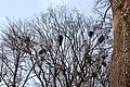
Rooks' nests on the treetops

.JPG)


.JPG)
Vegetation and animals
.jpg)
In spring blooming blue star , also known as Scilla popularly in the meadows and other spring flowers like crocuses . The tree population consists of beech, chestnut, oak and maple trees and some conifers. Some of the trees are as old as the park. Protected rooks nest in the treetops , which has repeatedly led to local protests. In the park there is a small pond with a fountain and ornamental fish.
Individual evidence
- ↑ a b c d Ralf Lienert, Michael Kobr: A day for Kempten. A guided tour through the oldest city in Germany. Allgäuer Zeitungsverlag, Kempten 2008, ISBN 978-3-88006-289-4 , p. 78.
- ↑ a b Ingrid Müller: The city park of Kempten - a natural monument. In: Allgäu my home. Heimatbund Allgäu , 1992, p. 17.
- ^ Martin Kellenberger: City of Kempten. Book of memory. Kempten 1937, p. 124f.
- ↑ a b c Peter Hutter: Back then in the Oberallgäu. Story (s) from the southernmost region of Germany. Edition Limosa, Clenze 2010, ISBN 978-3-86037-401-6 , p. 34f.
- ^ Franz-Rasso Böck : Adolf Horchler - a forgotten mayor? In: Allgäu history friend . No. 103, 2003, p. 167f.
- ^ Max Förderreuter: Kemptner Heimatbuch. Kempten 1932, p. 68.
- ^ Franz-Rasso Böck , Ralf Lienert , Joachim Weigel (eds.): Century views of Kempten 1900–2000 . Verlag Tobias Dannheimer - Allgäuer Zeitungsverlag, Kempten (Allgäu) 1999, ISBN 3-88881-035-3 , p. 121 .
- ^ Franz-Rasso Böck , Ralf Lienert , Joachim Weigel (eds.): Century views of Kempten 1900–2000 . Verlag Tobias Dannheimer - Allgäuer Zeitungsverlag, Kempten (Allgäu) 1999, ISBN 3-88881-035-3 , p. 124 .
- ↑ Information board of the city of Kempten am Teich in the city park, seen on September 23, 2012.
literature
- Max Kolb: The new city park in Kempten. Kösel-Verlag, Kempten 1894, OCLC 67333936 .
- Volker Dotter Weich: History of the City of Kempten. Dannheimer, Kempten 1989, ISBN 3-88881-011-6 , p. 387.
Web links
Coordinates: 47 ° 43 ′ 34.3 " N , 10 ° 18 ′ 44.8" E