Staiky (Kaharlyk)
| Staiky | ||
| Стайки | ||

|
|
|
| Basic data | ||
|---|---|---|
| Oblast : | Kiev Oblast | |
| Rajon : | Kaharlyk district | |
| Height : | 189 m | |
| Area : | 4.866 km² | |
| Residents : | 2,203 (2006) | |
| Population density : | 453 inhabitants per km² | |
| Postcodes : | 09210 | |
| Area code : | +380 4573 | |
| Geographic location : | 50 ° 5 ' N , 30 ° 54' E | |
| KOATUU : | 3222287601 | |
| Administrative structure : | 1 village | |
| Address: | Шкільна 1а 09210 с. Стайки |
|
| Statistical information | ||
|
|
||
Staiky ( Ukrainian Стайки ; Russian Стайки Staiki ) is a village in the Ukrainian Oblast of Kiev with about 2200 inhabitants (2006).
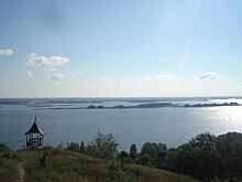
Staiky is located in the north of the Kaharlyk Rajon on the right bank of the Dnepr, which is dammed up to the Kaniv reservoir , in the middle between Kiev, 62 km upstream, and Kaniv, 62 km downstream . The village, founded in 1095, forms its own district council. The Kaharlyk district center is located 27 km south of the village.
Individual evidence
- ↑ Official site of the village Staiky on the website of the Verkhovna Rada , last accessed on December 27, 2014.
Web links
- Stajki . In: Filip Sulimierski, Władysław Walewski (eds.): Słownik geograficzny Królestwa Polskiego i innych krajów słowiańskich . tape 11 : Sochaczew – Szlubowska Wola . Walewskiego, Warsaw 1890, p. 176 (Polish, edu.pl ).
- Stajki, gmina Stajki . In: Filip Sulimierski, Władysław Walewski (eds.): Słownik geograficzny Królestwa Polskiego i innych krajów słowiańskich . tape 15 , part 2: Januszpol – Wola Justowska . Walewskiego, Warsaw 1902, p. 616 (Polish, edu.pl ).


