Starohorské vrchy
Coordinates: 48 ° 50 ′ N , 19 ° 12 ′ E

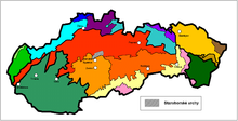
The Starohorské vrchy are a mountain range named after the place Staré Hory in central Slovakia , northeast of the city of Banská Bystrica . They are part of the Fatra-Tatra region of the Inner Western Carpathians . In the past, the region was regarded as the westernmost part of the Low Tatras , but according to a more recent geomorphological classification, it was regarded as an independent mountain range.
The mountains are limited
- in the north of the Great Fatra
- in the east of the Low Tatras ,
- in the south of the Zvolenská kotlina basin ,
- to the west of the Kremnick Mountains .
The main ridge of the approximately 20 km long and 10 km wide mountains runs from the southwest to the northeast. Here it connects to the ridges of the Great Fatra (over the Sedlo Donovaly pass ) and the Low Tatras (over the Hiadeľské sedlo saddle ). The highest peak is the Kozí chrbát with 1330 m.
The mountain range consists mainly of crystalline rock. The region, which used to be characterized by mining (especially copper ), now lives mainly from tourism and forestry .
Part of the mountain belongs to the Low Tatras National Park .
Significant surveys
- Kozí chrbát, 1330 m
- Kečka, 1225 m
- Jelenská skala, 1153 m
- Pansky Diel, 1100 m
Locations in the mountains and in the vicinity
- Banská Bystrica (German: Neusohl)
- Slovenská Ľupča (Slovak Liptsch)
- Staré Hory (Old Mountains)
- Špania Dolina (Herrengrund)
- Donovaly