
Steinbachquelle (Neukirchen near Sulzbach-Rosenberg)
| Steinbach spring | ||||
|---|---|---|---|---|
 Steinbachquelle in Steinbach |
||||
| location | ||||
| Country or region | Amberg-Sulzbach district , Upper Palatinate ( Bavaria ) | |||
| Coordinates | 49 ° 34 ′ 0 ″ N , 11 ° 39 ′ 7 ″ E | |||
|
||||
| geology | ||||
| Mountains | Franconian Alb | |||
| Source type | Karst spring | |||
| Hydrology | ||||
| River system | Rhine | |||
| Receiving waters | Mühlbach → Reinbach → Etzelbach → Högenbach → Pegnitz → Regnitz → Main → Rhine → North Sea | |||

Coordinates: 49 ° 34 ′ 0 ″ N , 11 ° 39 ′ 7 ″ E
The Steinbach spring , also known locally as the Mühlbach spring , is a karst spring in Steinbach , a village in the Upper Palatinate community of Neukirchen near Sulzbach-Rosenberg in the Amberg-Sulzbach district in Bavaria .
location
The Steinbach spring is located on the outskirts of Steinbach in the Franconian Switzerland-Veldenstein Forest Nature Park at an altitude of 490 m above sea level. NHN .
description
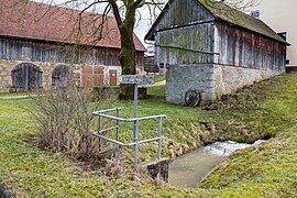
The karst spring with a relatively strong discharge of 15 to 20 liters per second rises from crevices in the deep karst . The outflowing Mühlbach , which runs approximately to the south, flows from the right with the left Eiselbach to the Reinbach at the end of its approximately 1.5 km long course after crossing the village of Oberreinbach in the municipality .
The spring is completely set in stone and used to provide people and animals with drinking water on site, which is still evidenced by the name of the former guest house Zur frisch Quelle , which is close to the spring . It pours quite heavily and constantly and drove a grain mill in Oberreinbach until the 1950s . Immediately after the source there is a two by two meter large Kallmünzer in the creek bed . This type of silicified sandstone can often be found in the area.
The source has been designated as a geotope (371Q001) by the Bavarian State Office for the Environment and is rated as significant.
Access
The spring is freely accessible all year round. The local hiking trail A Jura landscape tells its story - past and present it leads right past it.
Picture gallery

the stream flow with the Kallmünzer
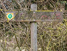
local name "Mühlbachquelle"
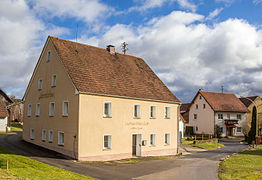
former inn "Fresh Source"
former flour mill in Oberreinbach


See also
Individual evidence
- ↑ BayernAtlas, location of the Steinbach spring (accessed on March 23, 2016)
- ↑ Brochure “A Jura Landscape Narrated - Past and Present” , page 13 (accessed on March 22, 2016)
- ↑ Geotope Steinbachquelle (accessed on March 23, 2016)
- ↑ OpenStreetMap: Course of the hiking trail (accessed on March 24, 2016)